Bellevue, Iowa
| Bellevue, Iowa | |
|---|---|
| City | |
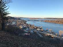 Downtown Bellevue, Lock & Dam No. 12, and the Mississippi River from the Bellevue State Park overlook. | |
| Motto(s): "A True Riverfront Experience"[1] | |
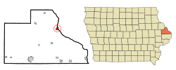 Location of Bellevue, Iowa | |
| Coordinates: 42°15′33″N 90°25′35″W / 42.25917°N 90.42639°WCoordinates: 42°15′33″N 90°25′35″W / 42.25917°N 90.42639°W | |
| Country |
|
| State |
|
| County | Jackson |
| Government | |
| • Mayor | Chris Rolling |
| Area[2] | |
| • Total | 1.41 sq mi (3.65 km2) |
| • Land | 1.34 sq mi (3.47 km2) |
| • Water | 0.07 sq mi (0.18 km2) |
| Elevation | 607 ft (185 m) |
| Population (2010)[3] | |
| • Total | 2,191 |
| • Estimate (2017)[4] | 2,175 |
| • Density | 1,635/sq mi (631.3/km2) |
| Time zone | UTC-6 (Central (CST)) |
| • Summer (DST) | UTC-5 (CDT) |
| ZIP code | 52031 |
| Area code(s) | 563 |
| FIPS code | 19-05635 |
| GNIS feature ID | 0454496 |
| Website | Bellevue, Iowa Website |
Bellevue (/ˈbɛlvjuː/) is a city in Jackson County, Iowa, United States. The city lies along the Mississippi River (Lock and Dam No. 12) and next to Bellevue State Park. In 2016 its population was 2,193; up from a count of 2,191 at the 2010 Census, making it the second largest city in Jackson County.
The city lies in a valley created by two large bluffs (known as North and South Bluffs respectively), with the Mississippi River serving as the city's eastern border (the Illinois state border), and with the Mill Creek valley extending to the west. Geographically, it is part of the southernmost region of the Driftless Area, a portion of North America that escaped all three phases of the Wisconsinian Glaciation.
It is one of the few cities in Iowa to boast large hills and bluffs, which account for much of the city's economic stimulation as a tourist town. The city attributes its name from the French words 'Belle' and 'Vue' meaning 'beautiful view', as well as an early settler, John D. Bell. The unique history, architecture, and beauty of Bellevue draw visitors year round. Exceptional public parks and recreation, outstanding education and emergency systems, and proximity to large population centers (including Dubuque and Maquoketa) make Bellevue a safe and beautiful place to live.
History
Jackson County, along with Jones and Linn Counties were established in 1837 and Bellevue was the named the seat of justice for all three counties. When Iowa became a territory in 1838, the first census was taken and Jackson County had 881 people. The Bellevue War of 1840 gave the town an unsavory reputation and discouraged settlement in its aftermath. However, the population would double within two years. In 1838 the town of Andrew was designated as the county seat. Between 1848 and 1876, the struggle between Andrew and Bellevue for the county seat continued with the county seat being moved from one town to the other several times, with Bellevue constructing a county courthouse that now serves as Bellevue Elementary. As the county was settled, Maquoketa would become the dominant centrally located town when the railroad reached Maquoketa in 1873. The Town of Maquoketa then built a large city hall and offered to lease the building to Jackson County as a courthouse. The proposition was put to a vote and approved, and since then, Maquoketa has been the county seat.[5]
The town was named for John D. Bell, a first settler, who built a cabin there in 1835.[6][7] Another likely reasoning for the city's name would be the French meaning of the name, "Beautiful View", alluding to the high wooded bluffs and expansive river views.
Geography
According to the United States Census Bureau, the city has a total area of 1.41 square miles (3.65 km2), of which, 1.34 square miles (3.47 km2) is land and 0.07 square miles (0.18 km2) is water.[2]
Climate
Bellevue has a humid continental climate (Köppen Dfa), which gives it four distinct seasons. However, local weather is often not as extreme as that found in other parts of the Midwest, such as Minnesota or Wisconsin. Spring is usually wet and rainy, summers are sunny and warm, autumn is mild, and winters are typically cloudy and snowy.
| Climate data for Bellevue, Iowa | |||||||||||||
|---|---|---|---|---|---|---|---|---|---|---|---|---|---|
| Month | Jan | Feb | Mar | Apr | May | Jun | Jul | Aug | Sep | Oct | Nov | Dec | Year |
| Record high °F (°C) | 63 (17) |
68 (20) |
87 (31) |
94 (34) |
94 (34) |
100 (38) |
102 (39) |
103 (39) |
99 (37) |
95 (35) |
77 (25) |
67 (19) |
103 (39) |
| Average high °F (°C) | 29 (−2) |
33 (1) |
46 (8) |
60 (16) |
71 (22) |
80 (27) |
84 (29) |
83 (28) |
75 (24) |
63 (17) |
47 (8) |
33 (1) |
59 (15) |
| Daily mean °F (°C) | 20 (−7) |
24.2 (−4.3) |
35 (2) |
48.7 (9.3) |
59.5 (15.3) |
69.1 (20.6) |
73.1 (22.8) |
71.4 (21.9) |
63.2 (17.3) |
52 (11) |
38 (3) |
25.1 (−3.8) |
48.3 (9.1) |
| Average low °F (°C) | 11 (−12) |
15 (−9) |
26 (−3) |
38 (3) |
48 (9) |
58 (14) |
62 (17) |
60 (16) |
52 (11) |
41 (5) |
29 (−2) |
17 (−8) |
38 (3) |
| Record low °F (°C) | −35 (−37) |
−34 (−37) |
−21 (−29) |
5 (−15) |
23 (−5) |
35 (2) |
41 (5) |
36 (2) |
24 (−4) |
14 (−10) |
−9 (−23) |
−26 (−32) |
−35 (−37) |
| Average precipitation inches (mm) | 1.3 (33) |
1.2 (30) |
2.2 (56) |
3.3 (84) |
3.8 (97) |
4.6 (117) |
3.7 (94) |
3.9 (99) |
3.6 (91) |
2.6 (66) |
2.3 (58) |
1.6 (41) |
34.1 (866) |
| Average snowfall inches (cm) | 8.9 (22.6) |
5.9 (15) |
4.4 (11.2) |
0.9 (2.3) |
0.1 (0.3) |
0 (0) |
0 (0) |
0 (0) |
0 (0) |
0 (0) |
1.2 (3) |
8 (20) |
29.4 (74.7) |
| Average precipitation days | 8 | 7 | 9 | 10 | 11 | 11 | 9 | 9 | 9 | 8 | 8 | 8 | 107 |
| Average snowy days | 5.1 | 3.5 | 1.8 | 0.3 | 0 | 0 | 0 | 0 | 0 | 0 | 0.7 | 4.6 | 16 |
| Source: Weatherbase[8] | |||||||||||||
Demographics
| Historical populations | ||
|---|---|---|
| Year | Pop. | ±% |
| 1850 | 362 | — |
| 1860 | 929 | +156.6% |
| 1870 | 1,353 | +45.6% |
| 1880 | 1,581 | +16.9% |
| 1890 | 1,394 | −11.8% |
| 1900 | 1,607 | +15.3% |
| 1910 | 1,776 | +10.5% |
| 1920 | 1,663 | −6.4% |
| 1930 | 1,717 | +3.2% |
| 1940 | 1,771 | +3.1% |
| 1950 | 1,932 | +9.1% |
| 1960 | 2,181 | +12.9% |
| 1970 | 2,336 | +7.1% |
| 1980 | 2,450 | +4.9% |
| 1990 | 2,239 | −8.6% |
| 2000 | 2,350 | +5.0% |
| 2010 | 2,191 | −6.8% |
| 2017 | 2,175 | −0.7% |
| Source:"American FactFinder". United States Census Bureau.
and Iowa Data Center Source: | ||
2010 census
As of the census[3] of 2010, there were 2,191 people, 966 households, and 584 families residing in the city. The population density was 1,635.1 inhabitants per square mile (631.3/km2). There were 1,120 housing units at an average density of 835.8 per square mile (322.7/km2). The racial makeup of the city was 99.0% White, 0.1% African American, 0.1% Native American, 0.2% from other races, and 0.6% from two or more races. Hispanic or Latino of any race were 0.8% of the population.
There were 966 households of which 24.9% had children under the age of 18 living with them, 50.0% were married couples living together, 7.2% had a female householder with no husband present, 3.2% had a male householder with no wife present, and 39.5% were non-families. 34.9% of all households were made up of individuals and 19.1% had someone living alone who was 65 years of age or older. The average household size was 2.20 and the average family size was 2.84.
The median age in the city was 46.8 years. 20.7% of residents were under the age of 18; 6.9% were between the ages of 18 and 24; 20.2% were from 25 to 44; 27.3% were from 45 to 64; and 24.9% were 65 years of age or older. The gender makeup of the city was 47.0% male and 53.0% female.
2000 census
As of the census[10] of 2000, there were 2,350 people, 942 households, and 629 families residing in the city. The population density was 2,410.7 people per square mile (935.4/km²). There were 1,012 housing units at an average density of 1,038.1 per square mile (402.8/km²). The racial makeup of the city was 99.79% White, 0.04% Asian, and 0.17% from two or more races. Hispanic or Latino of any race were 0.47% of the population.
There were 942 households out of which 32.2% had children under the age of 18 living with them, 56.6% were married couples living together, 7.7% had a female householder with no husband present, and 33.2% were non-families. 29.7% of all households were made up of individuals and 17.8% had someone living alone who was 65 years of age or older. The average household size was 2.41 and the average family size was 3.01.
25.4% are under the age of 18, 6.4% from 18 to 24, 25.1% from 25 to 44, 20.7% from 45 to 64, and 22.3% who were 65 years of age or older. The median age was 40 years. For every 100 females, there were 91.7 males. For every 100 females age 18 and over, there were 86.9 males.
The median income for a household in the city was $35,293, and the median income for a family was $44,438. Males had a median income of $35,507 versus $20,791 for females. The per capita income for the city was $15,928. About 5.0% of families and 7.3% of the population were below the poverty line, including 5.3% of those under age 18 and 13.1% of those age 65 or over.
Culture
Bellevue has a rich history that has greatly influenced the culture of the city. The prehistoric Woodland Native Americans made their homes in the fertile valleys where Bellevue lies. Much later, so did the Blackhawk tribe of which evidence can be found in the form of burial mounds high on the south bluff overlooking the river. The European pioneers arrived as fur traders, farmers, and merchants looking to settle new land beginning in 1833; many floating across the Mississippi River on logs. These early settlers formed Bell View, the oldest city in the county and one of the five oldest cities in Iowa. The spelling was later changed to the French, Belle Vue and in time the two words were united and the town became Bellevue.
Historic Sites
| Historical Site | Year Built | Location | Image | Description |
|---|---|---|---|---|
| Jackson County Courthouse | 1848 | 100 South Third Street, Bellevue |
|
Bellevue was named the county seat in 1837 before Iowa was a state. The Greek Revival style courthouse was built in 1848 to house the Jackson County Courthouse but in 1849, the county seat was moved from Bellevue to Andrew because it was a more central location. The structure was again the county courthouse from 1851 to 1861 during the controversy over where to locate the county seat and then moved again to Andrew after which the building was used as a public school. This style of courthouse is one of few remaining in the state. |
| Potter's Mill | 1843 | 300 Potter Drive, Bellevue |
|
Potter's Mill, a restaurant and bed and breakfast that was formerly a flour mill built in 1845 is located in Bellevue. Potter's Mill is currently named on the National Register of Historic Places.
Jasper Mill was built by Elbridge G. Potter to mill flour and this 3 story frame structure housed an active milling business until 1969. This mill made use of terraced rapids on Mill Creek with a 20-foot rock dam constructed by Potter to serve the turbines and grist mill. At Potter's Jasper Mill they purchased grain by the bushel, ground and bagged it, and sold under the Jasper name. These products of Jasper Mill enjoyed a national reputation. Nominated to the National Register of Historic Places in 1980, Potter's Mill has been restored. |
| George Dyas House | 1850's | 23852 362nd Avenue, Bellevue | 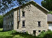 |
The George Dyas House is the westernmost of a group of houses and agricultural buildings known as the Dyas Farm. This limestone home is one of the first examples of limestone architecture in Jackson County. |
| William Dyas Barn | 1850's | 41088 243rd Street, Bellevue | 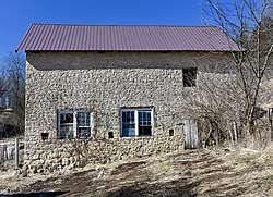 |
The William Dyas Barn is one of only 9 standing limestone barns in the county and is still in use. The barn is built into the side of a hill with the second floor door at ground level in back, a true bank barn. |
| Mont Rest | 1893 | 300 Spring Street, Bellevue | This building was built in 1893 for $6,000 by Seth Luellyn Baker. He was a wealthy land developer who owned hotels, gold mines and paddle boats on the Mississippi. Seth Baker was originally from Bellevue and came back to buy what was known as the north bluff of Bellevue. He named the property Mont Rest. The locals almost immediately started calling Mont Rest "The Castle" because of its unusual architecture and its towering presence over the town. |

Potter's Offices c.1850 101 North Riverview, Bellevue One of the county's earliest commercial buildings. E.G. Potter managed his extensive and varied business operations from this site. An early painting shows his wharf boat on the riverside. This limestone structure does not face the Mississippi, but backs on to the river. It appears to be a two story building from the front, but when viewed from the side, is actually four stories at the rear. Before the lock and dam was built, the river came right up to the rear of this building and river boats would tie up and unload cargo directly into the doors at the back.
Lucke Building c.1855
130-132 North Riverview, Bellevue
This 2 1/2 building is an excellent example of commercial design from the 1850s. Joseph Lucke opened his boot and shoe business in 1857 and his leather goods were widely know. In addition to local and riverborn business, his trade extended throughout the region. He did business with U.S. President Grant when Grant had a leather shop in Galena.
Haney Campbell Dairy 1859
306 South Second, Bellevue
This limestone commercial building's earliest use may have been a salt pork processing plant for the river trade. The building served as a dairy and creamery, later a saloon, pool hall and dwelling.
Kucheman Building 1868
101 North Second, Bellevue
Originally constructed as a dry goods store by Christian Kucheman and John Hinke, this is one of the last limestone commercial buildings constructed in Bellevue and the only limestone building featuring segmental arched windows. The building's second floor served as City Hall and an opera house for decades; the 30' × 50' addition at the rear was built before World War I.
Neimann House 1870
505 Court, Bellevue
Theodore Neimann is believed to be the first resident at this address. This limestone house exhibits rare "high style" Gothic Revival elements: delicate vergeboards on a steeply pitched gable roof and balconies located outside windows on the two primary facades.
Springside Inn 1850
300 Ensign Road, Bellevue
Springside was built by William Wynkoop, a local merchant. Members of the Wynkoop family resided here for 51 years. This home represents the only example of classic "rural" Gothic Revival architecture in its pure form and setting in the Midwest. A Springfield, IL, attorney named Abraham Lincoln was among Springside's early guests.
Henry Roling House c.1840
36170 308th Street, Bellevue
The Rolings came from Ankrum, Germany about 1833 and lived in a log home which stood in the farmyard until this stone house was finished. The floor plan is similar to the home of this countryman and fellow parishioner, Theodore Niemann, with the layout reversed.
Theodore Niemann Home & Springhouse 1845
35032 308th Street, Bellevue
The 1879 "History of Jackson County, Iowa" states that "this residence is the first stone house ever erected in the county . . . the spring house provides for the farm and at one time supplied water to a small brewery across the road." The house continues to be occupied by Nieman's descendants. The two story rectangular house with gabled roof is now painted white over a thin stucco.
Fritz Chapel 1852
34804 308th Street, Bellevue
Matthais Fritz, a stonemason, erected the Fritz Chapel in thanksgiving for the safe arrival of his family of eight after a terrifying sea and land voyage from Luxemborg. He carved the Crucifix and hewed the walnut arch from a single piece of wood. Fritz Chapel continues to be maintained by Matthais Fritz Chapel Fund, Incorporated.
Robb House c.1855
30602 Mill Creek Road
Built by E.G. Potter for John Robb, his foreman for Upper Paradise farms. The spring house stands to the west. The 6 over 6 windows are typical of those found on buildings from c. 1855 and the stucco appears to have been applied originally.
Big Mill Homestead c.1845 - 1850
32575 Mill Creek Road
This property is owned by the county and nestled at the edge of a conservation marshland. The two story farmhouse has a full walk in basement exposed on the west as the first of three floors. The basement houses building furnaces and ovens. Built possibly as a dormitory for Paradise Farms.
Upper Paradise c.1850
33616 Mill Creek Road
Built originally for Potter's only son, Lucius Byron Potter, though he never lived in it. Upper Paradise is covered with a thick layer of stucco and scored to look like cut ashlar limestone.
Paradise Farms 1846
34981 Mill Creek Road
Originally Potter's home, the main house is a stucco covered three story flat roof residence with a cupola. It houses the first lending library in Iowa as well as Captain Potter's correspondence and business records. Paradise has been home to generations of his descendants. The three story rectangular dormitory housed the buttery, farm's main kitchens and bunk quarters for workers and is now a family residence.
Dyas Hexagonal Barn 1921
41279 243rd Street, Bellevue
This unique shaped barn is one of a group of barns names to the National Register by Lowell Soike and included in his book "Without Right Angles"
Education

Public education
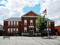
Bellevue High School is the main public school of Bellevue (which includes a middle school on the same campus). The school's colors are royal blue and white, and their mascot/team name is the Comets. The high school underwent significant renovations in 2010, with the addition of a stage, gymnasium, student commons, Hall of Pride, and district offices. The Bellevue Community School District also includes the public Bellevue Elementary School, located in the former Jackson County Courthouse built in 1845. The district supports free preschool and grades PK-12, with an enrollment of 675 students.
Private education
Marquette Catholic is a private school in town. Its colors are red and white, and its team name is the Mohawks. They support grades PK-12.
Infrastructure
Transportation
Highways
Bellevue radiates from the intersection of US HWY 52 (Riverview Dr.) and Iowa HWY 62 (State St). US HWY 52 continues north to St. Donatus and Dubuque and south to Sabula, before entering Savanna, Illinois via the new Dale Gardner Veterans Memorial Bridge. Highway 62 continues on to Andrew and terminates in the county seat, Maquoketa. Other roads coming into the city are Bellevue-Cascade Road (County D61) which terminates near Cascade, and Mill Creek Road (County D56) which terminates in La Motte.
River
Historically, there were hundreds of river steamboats that stopped at the grand staircase that led from the higher Riverfront Park to the riverbank to transfer passengers and necessary goods. The Mississippi River still is an essential route of economical transport for freight (with barges frequently passing), but no longer regularly carries commercial goods or passengers. Towards the mid 20th Century travel by riverboat was no longer the best mode of transportation, and that aspect of travel diminished along Bellevue's banks. In the 21st Century there has been an uptick in leisure cruises on recreations of large historical steamships that act as cruise vessels on the Mississippi. With Lock and Dam No. 12 bisecting the river, these steamships occasionally stop to let off passengers to shop and eat at establishments along Riverview Drive as they wait to lock through.
The city offers multiple locations to launch vessels, including the Municipal Boat Ramp (found below Riverview Park at the intersection of State Street and Riverview Drive), Bellevue Public Area Ramp (found south of town along US HWY 52), and at the Pleasant Creek Recreation Area (found 4 miles south of town along US HWY 52). Spruce Creek Park, located 3 miles north of Bellevue off of 395th Ave, offers a boat ramp as well as a large harbor for storage of boats, with some covered boat slips. The harbor is managed by Jackson County Conservation.[11]
Airport
The nearest moderately sized commercial airport is Dubuque Regional Airport south of Dubuque, IA along US HWY 61. Some small local airports in Maquoketa, Clinton, and Davenport serve small aircraft and agricultural purposes, with the nearest large commercial location being the Quad City International Airport in Moline, IL
Rail
In the center of the town, there is an on-street running railroad used by long freight trains. The railway is frequently used and divides Second Street on either side of it. Streets crossing this rail line include (from north to south) Jefferson Ave, Motte St, High St, Park St, Market St, State St (HWY 62), Jefferson St, Chestnut St, Vine St, and an underpass at the south end of 2nd St (Potter Dr). Formerly, a depot and rail yard supported passenger traffic along the now defunct Chicago, Bellevue, Cascade & Western Railway Company, which was a narrow-gauge railway[12]. Since its closure in the 1930's, the east-west running railroad was broken up, leaving the remaining north-south standard gauge rails that remain today under the control of the Alberta based Canadian Pacific Railway. There no longer are any passenger trains on Bellevue's rails.
See also
- Dyas Hexagonal Barn, listed on the National Register of Historic Places
References
- ↑ "Bellevue, Iowa". Bellevue, Iowa. Retrieved May 25, 2018.
- 1 2 "US Gazetteer files 2010". United States Census Bureau. Archived from the original on 2012-01-24. Retrieved 2012-05-11.
- 1 2 "American FactFinder". United States Census Bureau. Retrieved 2012-05-11.
- ↑ "Population and Housing Unit Estimates". Retrieved June 9, 2017.
- ↑ "49. JACKSON COUNTY, IOWA." Iowa Genealogical Society. N.p., n.d. Web. 6 July 2010. <www.iowagenealogy.org/CountyResearchGuide/JacksonCoGuide.htm>.
- ↑ "Bellevue, Iowa City Information." ePodunk. N.p., n.d. Web. 7 July 2010. <http://www.epodunk.com/cgi-bin/genInfo.php?locIndex=7164>.
- ↑ Owen's Gazetteer and Directory of Jackson County, Iowa. Walsworth. 1878. p. 59.
- ↑ "Weatherbase: Historical Weather for Bellevue, Iowa". Retrieved May 25, 2018.
- ↑ "Census of Population and Housing". Census.gov. Archived from the original on May 12, 2015. Retrieved June 4, 2015.
- ↑ "American FactFinder". United States Census Bureau. Archived from the original on 2013-09-11. Retrieved 2008-01-31.
- ↑ https://www.mycountyparks.com/county/Jackson/Park/Spruce-Creek-Park.aspx
- ↑ http://www.encyclopediadubuque.org/index.php?title=NARROW_GAUGE_RAILROAD
External links
| Wikimedia Commons has media related to Bellevue, Iowa. |
Municipalities and communities of Jackson County, Iowa, United States | ||
|---|---|---|
| Cities | ||
| Townships | ||
| Unincorporated communities | ||
| Footnotes | ‡This populated place also has portions in an adjacent county or counties | |