Stepaside, Dublin
| Stepaside An Chéim | |
|---|---|
| Village | |
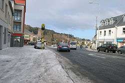 Stepaside main street | |
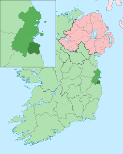
 Stepaside Location in Ireland | |
| Coordinates: 53°15.17′N 6°12.845′W / 53.25283°N 6.214083°WCoordinates: 53°15.17′N 6°12.845′W / 53.25283°N 6.214083°W | |
| Country | Ireland |
| County | Dún Laoghaire–Rathdown |
| Time zone | UTC+0 (WET) |
| • Summer (DST) | UTC-1 (IST (WEST)) |
| Eircode (Routing Key) | D18 |
| Area code(s) | 01 (+3531) |
| Irish Grid Reference | O189241 |
| Website |
www |
Stepaside (Irish: An Chéim) is a village on the outskirts of Dublin located on its southside, located in Dún Laoghaire–Rathdown, Ireland. The area is situated 4 kilometres south of Dundrum.
Location and access
A suburb of Dublin, Stepaside lies on the R117 regional road to the south-east of the city, at the foot of Three Rock Mountain. The area is located just off Junction 14 of the M50 motorway. Neighbouring areas include Sandyford, Kilternan, Ballyogan, Leopardstown, Carrickmines and Glencullen.
Stepaside village developed in the 18th and early 19th centuries when the adjacent medieval settlement of Kilgobbin was bypassed by a new stretch of the Enniskerry Road, built from what is now Lamb's Cross through to Kilternan. Stepaside became a new staging post along this route, while Kilgobbin Road with its coaching inn (now Oldtown House) was no longer used by goods traffic or stage coaches.
Stepaside is served by Dublin Bus routes 44, 47,63 and 118 The Luas Green Line has been extended to Cherrywood and the nearest stops (Glencairn or The Gallops) are approx 2 kilometres from the centre of Stepaside.
Development
Since 2002 the Stepaside area has witnessed an extensive homebuilding programme and an accompanying large growth in population. Previously a separate rural village, it has been absorbed by the Dublin conurbation to the north and east. Dún Laoghaire-Rathdown County Council recently announced plans to build a community park for the Carrickmines, Ballyogan, and Stepaside areas at a cost of €40 million; a large civic centre is currently being built and the park will be named after Samuel Beckett.
Stepaside contains several shops and pubs. The Step Inn, The Stone Grill,[1] The Box Tree,[2]and Quattro provide choice in dining. In recent times a new medical practice, 'Stepaside Medical', and Mulvey's Pharmacy have opened in the village.[3]
Localities and housing developments
- Stepaside Park Estate, a mixture of high density apartments and low density housing located beside Saint Patrick's Park, south of the village.
- Belarmine, Parkview and Littlewood, situated off the Enniskerry Road to the north of the village, are high density developments.
- Saint Patrick's Park, in the village center, beside Stepaside Park.
- Kilgobbin estate, a low density development.
- Wingfield, Cruagh Manor and Cairnfort, are estates off the Enniskerry Road, to the south of Stepaside Park.
- The Village - New Apartments above Morgan and Macs & Centra in Stepaside
Sport
Soccer (Association football)
- Wayside Celtic F.C. (Kilternan)
- All Weather Pitch Jamestown Stepaside
GAA
Nearby clubs include
- Naomh Olaf (Sandyford)
- Kilmacud Crokes (Stillorgan)
- Stars of Erin (Glencullen)
Rugby
Golf
- Stepaside Golf Centre & Driving Range
- Jamestown Par 3 Golf Course
- The Burrow par 3 Golf Course
- Stepaside Golf Course
- Glencullen Golf Cource
- Sandyford Par 3 Golf Course
People
- Joe Elliott, the lead singer of Def Leppard.
- Hal Roach, comedian.
- Ronnie Delany, Olympic Gold Medilist.
See also
References
- ↑ "The StoneGrill - The Step Inn". The Step Inn. Retrieved 16 March 2018.
- ↑ "Sorry The Wild Boar is closed". www.menupages.ie. Retrieved 16 March 2018.
- ↑ "Planning Application Details". planning.dlrcoco.ie. Retrieved 16 March 2018.
Places in Dún Laoghaire–Rathdown | ||
|---|---|---|
| Villages and suburbs |
|  |
| ||