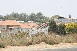
Beit Hashmonai
| Beit Hashomai בֵּית חַשְׁמוֹנַאי | |
|---|---|
 | |
 Beit Hashomai | |
| Coordinates: 31°53′25.79″N 34°54′57.96″E / 31.8904972°N 34.9161000°ECoordinates: 31°53′25.79″N 34°54′57.96″E / 31.8904972°N 34.9161000°E | |
| District | Central |
| Council | Gezer |
| Founded | 1970 |
| Founded by | Jewish Agency |
| Population (2017)[1] | 2,195 |
Beit Hashmonai (Hebrew: בֵּית חַשְׁמוֹנַאי, lit. Hasmonean House) is a Jewish locality in central Israel. Located five kilometers south-east of Ramla,[2] it falls under the jurisdiction of Gezer Regional Council. In 2017 it had a population of 2,195.[1]
History
Beit Hashmonai was established in 1970 by the Jewish Agency for teachers at the nearby Ayalon School on land that had belonged to the depopulated Palestinian village of al-Barriyya.[3] It is named for Simon Maccabaeus, a member of the Hasmonean family who captured the ancient city of Gezer, located nearby.
In 1987 it was designated a community centre for the regional council, with the council's offices moved to the village.[4]
References
- 1 2 "List of localities, in Alphabetical order" (PDF). Israel Central Bureau of Statistics. Retrieved August 26, 2018.
- ↑ The Ratzhabis of Beit Hashmonai
- ↑ Khalidi, Walid (1992). All That Remains: The Palestinian Villages Occupied and Depopulated by Israel in 1948. Washington D.C.: Institute for Palestine Studies. p. 362. ISBN 0-88728-224-5.
- ↑ Homepage Beit Hashmonai
External links
| Wikimedia Commons has media related to Beit Hashmonay. |
This article is issued from
Wikipedia.
The text is licensed under Creative Commons - Attribution - Sharealike.
Additional terms may apply for the media files.