Bearcreek Township, Jay County, Indiana
| Bearcreek Township | |
|---|---|
| Township | |
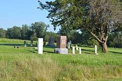 Small cemetery east of Bryant | |
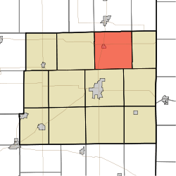 Location in Jay County | |
| Coordinates: 40°31′35″N 84°55′51″W / 40.52639°N 84.93083°WCoordinates: 40°31′35″N 84°55′51″W / 40.52639°N 84.93083°W | |
| Country | United States |
| State | Indiana |
| County | Jay |
| Government | |
| • Type | Indiana township |
| Area | |
| • Total | 36.25 sq mi (93.9 km2) |
| • Land | 36.23 sq mi (93.8 km2) |
| • Water | 0.01 sq mi (0.03 km2) 0.03% |
| Elevation | 863 ft (263 m) |
| Population (2010) | |
| • Total | 1,578 |
| • Density | 43.6/sq mi (16.8/km2) |
| GNIS feature ID | 0453101 |
Bearcreek Township is one of twelve townships in Jay County, Indiana, United States. As of the 2010 census, its population was 1,578 and it contained 472 housing units.[1]
History
Bearcreek Township was organized in 1836.[2]
Geography
According to the 2010 census, the township has a total area of 36.25 square miles (93.9 km2), of which 36.23 square miles (93.8 km2) (or 99.94%) is land and 0.01 square miles (0.026 km2) (or 0.03%) is water.[1] The streams of Deer Creek and Tri Run run through this township.
Cities and towns
Unincorporated towns
Adjacent townships
- Wabash Township, Adams County (north)
- Jefferson Township, Adams County (northeast)
- Wabash Township (east)
- Noble Township (southeast)
- Wayne Township (south)
- Jackson Township (west)
- Hartford Township, Adams County (northwest)
Cemeteries
The township contains three cemeteries: Borris, Old Baptist and Pingrey.
Major highways
References
- "Bearcreek Township, Jay County, Indiana". Geographic Names Information System. United States Geological Survey. Retrieved 2009-09-24.
- United States Census Bureau cartographic boundary files
- 1 2 "Population, Housing Units, Area, and Density: 2010 - County -- County Subdivision and Place -- 2010 Census Summary File 1". United States Census. Retrieved 2013-05-10.
- ↑ Jay, Milton T. (1922). History of Jay County, Indiana: Including Its World War Record and Incorporating the Montgomery History, Volume 1. Historical Publishing Company. p. 98.
External links
Municipalities and communities of Jay County, Indiana, United States | ||
|---|---|---|
| Cities | ||
| Towns | ||
| Townships | ||
| Unincorporated communities | ||
| Footnotes | ‡This populated place also has portions in an adjacent county or counties | |
This article is issued from
Wikipedia.
The text is licensed under Creative Commons - Attribution - Sharealike.
Additional terms may apply for the media files.