South-West Oxford
| South-West Oxford | |
|---|---|
| Township (lower-tier) | |
| Township of South-West Oxford | |
 South-West Oxford | |
| Coordinates: 42°57′N 80°48′W / 42.950°N 80.800°WCoordinates: 42°57′N 80°48′W / 42.950°N 80.800°W | |
| Country |
|
| Province |
|
| County | Oxford |
| Formed | 1975 |
| Government | |
| • Mayor | David Mayberry |
| • Federal riding | Oxford |
| • Prov. riding | Oxford |
| Area[1] | |
| • Land | 370.48 km2 (143.04 sq mi) |
| Population (2011)[1] | |
| • Total | 7,544 |
| • Density | 20.4/km2 (53/sq mi) |
| Time zone | UTC-5 (EST) |
| • Summer (DST) | UTC-4 (EDT) |
| Postal Code | N0J |
| Area code(s) | 519 and 226 |
| Website | www.swox.org |
South-West Oxford is a township in the Canadian province of Ontario, located within Oxford County. The township had a population of 7,544 in the 2011 Canadian census. A predominantly rural municipality, South-West Oxford was formed in 1975 through the amalgamation of Dereham and West Oxford townships
Communities
The township includes the following communities within its boundaries:[2]
- Beachville
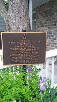
- The first game of baseball was played in this community on 4 June 1838, a year before the Cooperstown Game. The Beachville Club and the Zorras were the teams playing on this occasion.[3] By 1869, Beachville was a Village with a population of 700 in the Township of Wext County Oxford. The village, which was on the Great Western Rail way and River Thames, contained 1 flour mill, 1 flax mill, 1 foundry, 2 saw mills, 2 tanneries, 4 churches, 2 common schools, and 3 hotels. There was a Stage to Embro Brooksdale and Stratford. The average price of land $30 to $40. [4] The postal code for Beachville is N0J1A0.
- Brownsville
- Brownsville Station
- Centreville - the first site of European settlement and a primary school for grades 1-8 in the 1960s. Home of Centerville Pond.
- Culloden
- Delmer
- Dereham Centre
- The municipal offices of South-West Oxford are located in Dereham Centre.
- Foldens
- Hagles Corners
- Mount Elgin
- Located along Highway 19, south of Salford and north of Ostrander.
- Ostrander
- Salford: A small village along Highway 19 consisting of approximately 50 households. It is surrounded by agricultural land and the Oxford landfill to the east. The extent of its commercial infrastructure is a gasbar/garage which suffered a fire in 2004, and a post office/variety store/cheese museum. In addition, there was once a dairy and cheese mill, which was closed and now lies derelict. Other notable buildings include two churches, one which was recently closed due to a lack of funding, and the Salford Community Centre with a ball diamond. Salford was the birthplace of Aimee Semple McPherson.
- Sweaburg
- Sweaburg is located 5 km southwest of Woodstock. Its main intersection is Sweaburg Road and Dodge Line (County Roads 12 and 41). It had a public school for students up to grade three until 2009, and currently has Sweaburg United Church and cemetery, a ball diamond, and a convenience store.
- Verschoyle
- Zenda
Attractions
- Beachville District Museum
- Jakeman's Maple Farm
Climate
| Climate data for Foldens, Ontario | |||||||||||||
|---|---|---|---|---|---|---|---|---|---|---|---|---|---|
| Month | Jan | Feb | Mar | Apr | May | Jun | Jul | Aug | Sep | Oct | Nov | Dec | Year |
| Record high °C (°F) | 15.0 (59) |
19.0 (66.2) |
24.0 (75.2) |
29.5 (85.1) |
32.5 (90.5) |
35.5 (95.9) |
36.5 (97.7) |
37.0 (98.6) |
33.3 (91.9) |
28.3 (82.9) |
20.6 (69.1) |
18.0 (64.4) |
37.0 (98.6) |
| Average high °C (°F) | −2.9 (26.8) |
−1.8 (28.8) |
3.6 (38.5) |
11.2 (52.2) |
18.7 (65.7) |
23.6 (74.5) |
25.9 (78.6) |
25.0 (77) |
20.6 (69.1) |
13.7 (56.7) |
6.3 (43.3) |
0.0 (32) |
12.0 (53.6) |
| Daily mean °C (°F) | −6.3 (20.7) |
−5.4 (22.3) |
−0.3 (31.5) |
6.5 (43.7) |
13.3 (55.9) |
18.3 (64.9) |
20.7 (69.3) |
19.9 (67.8) |
15.7 (60.3) |
9.4 (48.9) |
3.0 (37.4) |
−3.1 (26.4) |
7.6 (45.7) |
| Average low °C (°F) | −9.7 (14.5) |
−9 (16) |
−4.3 (24.3) |
1.7 (35.1) |
7.9 (46.2) |
12.9 (55.2) |
15.4 (59.7) |
14.8 (58.6) |
10.8 (51.4) |
4.9 (40.8) |
−0.3 (31.5) |
−6.2 (20.8) |
3.3 (37.9) |
| Record low °C (°F) | −31 (−24) |
−26.5 (−15.7) |
−22.8 (−9) |
−13 (9) |
−4 (25) |
0.0 (32) |
4.0 (39.2) |
2.0 (35.6) |
−1.1 (30) |
−8.3 (17.1) |
−15.5 (4.1) |
−24 (−11) |
−31 (−24) |
| Average precipitation mm (inches) | 65.6 (2.583) |
51.3 (2.02) |
74.3 (2.925) |
79.4 (3.126) |
77.5 (3.051) |
86.6 (3.409) |
98.8 (3.89) |
93.3 (3.673) |
91.7 (3.61) |
77.1 (3.035) |
87.6 (3.449) |
75.7 (2.98) |
958.9 (37.752) |
| Average rainfall mm (inches) | 32.7 (1.287) |
28.3 (1.114) |
57.2 (2.252) |
73.9 (2.909) |
77.1 (3.035) |
86.6 (3.409) |
98.8 (3.89) |
93.3 (3.673) |
91.7 (3.61) |
76.1 (2.996) |
76.6 (3.016) |
47.2 (1.858) |
839.4 (33.047) |
| Average snowfall cm (inches) | 32.9 (12.95) |
23.1 (9.09) |
17.1 (6.73) |
5.6 (2.2) |
0.4 (0.16) |
0 (0) |
0 (0) |
0 (0) |
0 (0) |
1.0 (0.39) |
11.0 (4.33) |
28.5 (11.22) |
119.5 (47.05) |
| Average precipitation days (≥ 0.2 mm) | 15.8 | 12.3 | 13.3 | 13.6 | 12.6 | 11.1 | 11.6 | 11.4 | 12.6 | 12.5 | 14.9 | 15.2 | 157.0 |
| Average rainy days (≥ 0.2 mm) | 4.6 | 4.5 | 7.7 | 11.8 | 12.5 | 11.1 | 11.6 | 11.4 | 12.6 | 12.5 | 11.4 | 6.5 | 118.1 |
| Average snowy days (≥ 0.2 cm) | 12.2 | 9.0 | 6.6 | 2.5 | 0.13 | 0 | 0 | 0 | 0 | 0.27 | 4.5 | 10.1 | 45.2 |
| Source: Environment Canada[5] | |||||||||||||
Demographics
| Canada census – South-West Oxford community profile | |||
|---|---|---|---|
| 2011 | 2006 | ||
| Population: | 7544 (-0.6% from 2006) | 7589 (-2.5% from 2001) | |
| Land area: | 370.48 km2 (143.04 sq mi) | 370.63 km2 (143.10 sq mi) | |
| Population density: | 20.4/km2 (53/sq mi) | 20.5/km2 (53/sq mi) | |
| Median age: | 39.4 (M: 39.2, F: 39.6) | 37.7 (M: 37.4, F: 37.9) | |
| Total private dwellings: | 2695 | 2667 | |
| Median household income: | $65664 | ||
| References: 2011[6] 2006[7] earlier[8] | |||
Population trend:[9]
- Population in 2006: 7589
- Population in 2001: 7782
- Population in 1996: 8441 (or 7788 when adjusted to 2001 boundaries)
- Population in 1991: 8514
See also
References
- 1 2 "South-West Oxford census profile". 2011 Census of Population. Statistics Canada. Retrieved 2012-08-09.
- ↑ Township of South-West Oxford
- ↑ Beachville District Museum
- ↑ The province of Ontario gazetteer and directory. H. McEvoy Editor and Compiler, Toronto : Robertson & Cook, Publishers, 1869
- ↑ Canadian Climate Normals 1971-2000 Environment Canada. Retrieved October 31, 2012.
- ↑ "2011 Community Profiles". Canada 2011 Census. Statistics Canada. July 5, 2013. Retrieved 2012-08-09.
- ↑ "2006 Community Profiles". Canada 2006 Census. Statistics Canada. March 30, 2011. Retrieved 2011-02-09.
- ↑ "2001 Community Profiles". Canada 2001 Census. Statistics Canada. February 17, 2012.
- ↑ Statistics Canada: 1996, 2001, 2006 census
External links
Places adjacent to South-West Oxford | ||||||||||
|---|---|---|---|---|---|---|---|---|---|---|
| ||||||||||
This article is issued from
Wikipedia.
The text is licensed under Creative Commons - Attribution - Sharealike.
Additional terms may apply for the media files.