Barlaston
| Barlaston | |
|---|---|
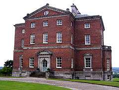 Barlaston Hall | |
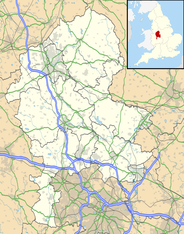 Barlaston Barlaston shown within Staffordshire | |
| Population | 2,858 (2011)[1] |
| OS grid reference | SJ894387 |
| District | |
| Shire county | |
| Region | |
| Country | England |
| Sovereign state | United Kingdom |
| Post town | Stoke-on-Trent |
| Postcode district | ST12 |
| Dialling code | 01782 |
| Police | Staffordshire |
| Fire | Staffordshire |
| Ambulance | West Midlands |
| EU Parliament | West Midlands |
| UK Parliament | |
Barlaston is a village and civil parish in the borough of Stafford in the county of Staffordshire, England. It is roughly halfway between the city of Stoke-on-Trent and the small town of Stone. According to the 2001 census the population of the parish was 2,659, rising at the 2011 Census to 2,858.
History
The old parish church of Saint John [2] is sited on the edge of the Wedgwood estate. It was built to the design of Charles Lynam in 1886-8, retaining the west tower from the original medieval building, with the subsequent addition of a vestry in 1969. In 1981 the building had to be closed owing to mining subsidence and a temporary building next to the church took its place until the new church was built on Green Lane.
Wedgwood moved their pottery manufacturing business from Etruria, Staffordshire to a large modern factory in a new village in the north of the parish. The factory was planned in 1936 and built in 1938-40 to the designs of Keith Murray who was also a designer of Wedgwood pottery. The factory has a tourist visitor centre containing the Wedgwood Museum,[3] with its own car-parks and a bus station.
Wedgwood railway station was opened for the factory in 1940 and is currently served by rail replacement bus (First Potteries No 23) on which all valid railway tickets and passes are accepted. Nearby is Barlaston Hall c. 1756 by Sir Robert Taylor (architect) and at one time a Wedgwood family home. The Upper House Hotel,[4] another Wedgwood residence, is also in Barlaston.
Education
- Barlaston First School
- 140 years of Barlaston First school
- The Wedgwood Memorial College in Barlaston is a Worker's Educational Association residential college, and also serves as the headquarters of the Esperanto Association of Britain.
Transport & Local amenities

Close by the village are: the A34 road; the River Trent; the Trent and Mersey Canal; a route of National Cycle Network; and the railway - which all pass west of the village.
Barlaston railway station, opened by the North Staffordshire Railway on 17 April 1848, is now on the Manchester branch of the West Coast Main Line - but inter-city trains do not stop and the local passenger service was taken over by rail replacement bus (First Potteries No 23) in 2014, on which all valid railway tickets and passes are accepted. The campaign for the local train service to be restored is continuing.[5]
D&G Bus services [6] 12 & 14 from Hanley to Stafford via Trentham, Eccleshall and Stone run through Barlaston
Barlaston Golf Club [7] is situated to the south of the town.
Environment
Barlaston and Rough Close Common covers some 50 acres (20 ha) between Barlaston and Blythe Bridge and is a designated local nature reserve.[8][9]
Downs Banks is located a little to the south-east of Barlaston. It is owned and managed by the National Trust and is also known as 'Barlaston Downs'
Notable people
- Francis Wedgwood (1800 – 1888 in Barlaston) a grandson of the English potter Josiah Wedgwood
- Edward Proctor (1870 in Barlaston – 1944) an English footballer who played for Stoke & Port Vale
- Josiah Wedgwood, 1st Baron Wedgwood DSO, PC, DL (1872 in Barlaston – 1943) Josiah Wedgwood IV a British Liberal and Labour politician, the great-great-grandson of Josiah Wedgwood, MP for Newcastle-under-Lyme 1906-1942.
- Felix Wedgwood (1877 in The Upper House, Barlaston – 1917) an English author, mountaineer and soldier who died on active service in WWI
- Horace Barks OBE (1895-1983) Lord Mayor of Stoke-on-Trent in 1951–2, cultural interests were Esperanto and the writer Arnold Bennett.
- Harry Davies (1904–1975) an English footballer, played over 400 games for Stoke City & Port Vale, subsequently owner and landlord of the Plume of Feathers
Nearby places
References
- ↑ "Civil Parish population 2011". Retrieved 3 December 2015.
- ↑ Website of Potteries.org - Neville Malkin's "Grand Tour" of the Potteries Retrieved Feb 2017 = Has several old pictures, drawings and historical narrative about St. John's Church, Barlaston
- ↑ World of Wedgwood website retrieved Jan 2017
- ↑ Upper House Hotel website retrieved Jan 2017
- ↑ North Staffs Rail Promotion Group website retrieved Jan 2017
- ↑ D&G Bus website, list of services Archived 2017-01-04 at the Wayback Machine. retrieved Jan 2017
- ↑ Barlaston Golf Club website retrieved Jan 2017
- ↑ "Barlaston and Rough Close Common". Local Nature Reserves. Natural England. Archived from the original on 8 August 2014. Retrieved 4 August 2013.
- ↑ "Map of Barlaston and Rough Close Common". Local Nature Reserves. Natural England. Retrieved 4 August 2013.
Further reading
- Nikolaus Pevsner The Buildings of England - Staffordshire. Harmondsworth: Penguin Books, 1974; p. 65
External links
| Wikimedia Commons has media related to Barlaston. |