Tha Chang District, Surat Thani
| Tha Chang ท่าฉาง | |
|---|---|
| Amphoe | |
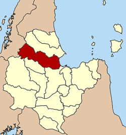 Amphoe location in Surat Thani Province | |
| Coordinates: 9°16′51″N 99°12′3″E / 9.28083°N 99.20083°ECoordinates: 9°16′51″N 99°12′3″E / 9.28083°N 99.20083°E | |
| Country | Thailand |
| Province | Surat Thani |
| Seat | Khao Than |
| Area | |
| • Total | 1,167.7 km2 (450.9 sq mi) |
| Population (2005) | |
| • Total | 31,013 |
| • Density | 26.56/km2 (68.8/sq mi) |
| Time zone | UTC+7 (ICT) |
| Postal code | 84150 |
| Geocode | 8411 |
Tha Chang (Thai: ท่าฉาง, pronounced [tʰâː t͡ɕʰǎːŋ]) is a district (amphoe) in the west of Surat Thani Province of southern Thailand.
Neighboring districts are Chaiya to the north, the Bandon Bay to the east, Phunphin, Vibhavadi and Ban Ta Khun to the south, and to the west the district Kapoe of Ranong Province.
History
The minor district (king amphoe) was created on 31 July 1908, consisting of tambons Than, Pak Chalui, and Sawiat of Phum Riang District and Tha Khoei, Tha Chang, and Khlong Sai of Phunphin District. The minor district was made a subordinate of Phum Riang District.[1] It was upgraded to a full district on 1 August 1938.[2]
Geography
The district extends from the coast to the Bandon Bay in the east to the ridges of the Phuket mountain range, which forms the boundary between the provinces Surat Thani and Ranong. Located in these hills is the Kaeng Krung National Park.
The district is crossed by the southern railway, as well as Asian highway AH2.
Administration
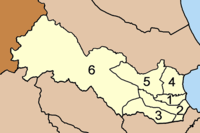
The district is divided into six sub-districts (tambon), which in turn are subdivided into 46 villages (muban). Each of the tambons is administered by a tambon administrative organization (TAO). Tha Chang itself has township (thesaban tambon) status and covers parts of tambons Tha Chang and Khao Than.
|
 |
References
- ↑ แจ้งความกระทรวงมหาดไทย (PDF). Royal Gazette (in Thai). 25 (19): 569. August 9, 1908.
- ↑ ประกาศสำนักนายกรัฐมนตรี เรื่อง ยกฐานะกิ่งอำเภอท่าฉางเป็นอำเภอและยุบอำเภอพระแสงลงเป็นกิ่งอำเภอ (PDF). Royal Gazette (in Thai). 55 (0 ง): 1321–1322. August 1, 1938.
External links
- https://web.archive.org/web/20050508195922/http://www2.suratthani.go.th/poc/aumphur/thachang.doc
- amphoe.com