Ball Ground Historic District
|
Ball Ground Historic District | |
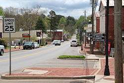 Georgia Rte 372 in Ball Ground Historic District | |
 | |
| Location | Ball Ground, Georgia |
|---|---|
| Coordinates | 34°20′21″N 84°22′41″W / 34.339158°N 84.378172°W. |
| Area | 22 acres (8.9 ha) |
| Architectural style |
Late-Victorian (Queen Anne and Italianate); Late 19th and Early 20th Century Revivals (Colonial Revival, Classical Revival, Commercial Style, and Bungalow/Craftsman) |
| NRHP reference # | 09001057[1] |
| Added to NRHP | December 4, 2009 |
The Ball Ground Historic District in Ball Ground, Georgia is a 22 acres (8.9 ha) historic district which is roughly bounded by Highway 5 to the west; Commerce Street and Groover Street to the north; Valley Street and Gazaway Lane to the east; and Stripling Street, the southern terminus of Old Canton Road, and Depot Street to the south. It was listed on the National Register of Historic Places in 2009 and included several contributing buildings.
See also
References
- ↑ National Park Service (2013-11-02). "National Register Information System". National Register of Historic Places. National Park Service.
| Topics | |
|---|---|
| Lists by states |
|
| Lists by insular areas | |
| Lists by associated states | |
| Other areas | |
| |
This article is issued from
Wikipedia.
The text is licensed under Creative Commons - Attribution - Sharealike.
Additional terms may apply for the media files.