Baihe County
| Baihe County 白河县 | |
|---|---|
| County | |
 Baihe in Ankang | |
.png) Ankang in Shaanxi | |
| Country | People's Republic of China |
| Province | Shaanxi |
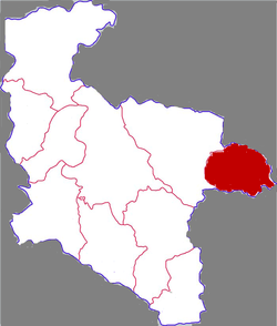
| Prefecture-level city | Ankang |
| Area | |
| • Total | 1,450 km2 (560 sq mi) |
| Population (2002) | |
| • Total | 2,070,000 |
| • Density | 1,400/km2 (3,700/sq mi) |
| • Rural | 1,870,000 |
| Time zone | UTC+8 (China standard time) |
Baihe (Chinese: 白河; pinyin: Báihé; literally: "white river") is located in the southeastern portion of Shaanxi province, China and is the easternmost county-level division under the jurisdiction of the prefecture-level city of Ankang. It is by the eastern part of the Daba Mountains and approaches the Han River on the north. On the east it borders Yun County (Hubei), on the south Zhushan County (Hubei), on the west Xunyang County, and is separated from Yunxi County (Hubei) by a river.
Baihe County is approximately the area from E 109°37 to 110°10' and N 32°34' to 32°55'. It is in the north subtropical to warm temperate transitional climatic zone, and is part of the continental seasonal monsoon climate zone. The average temperature is 12.2 to 16.5 °C (54.0 to 61.7 °F), average yearly sunlight 1753.8 hours, average rainfall 787.5 mm (31.00 in), and has 234 to 261 frost-free days each year.
Baihe was historically nicknamed "The Head of Qin and the Tail of Wei." It is a largely rural county, populated mainly by Han Chinese. Divisions contained in Baihe County are: Chengguan Town, Zhongchang Town, Gouba Town, Kazi Town, Maoping Town, Songjia Town, Xiying Town, Cangshang Town, Lengshui Town, as well as Sixi Village, Taoyuan Village, Shuanghe Village, Xiaoshuang Village, Dashuang Village, and Mahu Village.
Baihe's main outside transportation connection is the Xiangyu Railway.
Coordinates: 32°42′51″N 109°55′16″E / 32.71417°N 109.92111°E