Ba Vì District
| Ba Vì | |
|---|---|
| Municipality | |
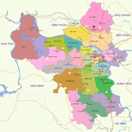 Districts of Hà Nội (Ba Vì furthest West) | |
| Coordinates: Coordinates: 21°04′0″N 105°20′05″E / 21.06667°N 105.33472°E | |
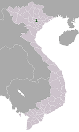
| Country |
|
| Area | |
| • Total | 428 km2 (165 sq mi) |
| Population (2003[1]) | |
| • Total | 265,000 |
History
Ba Vi District was established in July 26, 1968 on a consolidated basis of the old districts Bat Bat, Tung Thien and Quang Oai Ha Tay province. During the period 1975-1978, Ba Vi district belonged to Ha Son Binh province and from 1978 to 1991, it belonged to Ha Noi city. In 1982, 7 communes: Co Dong, Duong Lam, Kim Son, Son Dong, Thanh My, Trung Son Tram, Xuan Son were managed by Son Tay town and 2 communes: Tich Giang, Trach My Loc were managed by Phuc Tho district. In 1987, Quang Oai town was established and belonged to Ha Tay from 1991 to 2008. In 1994, the town of Quang Oai and Tay Dang commune were consolidated to form Tay Dang town. From August 1, 2008, Ba Vi became a district of Hanoi again. At the same time, Tan Duc moved to the managemnent of Viet Tri city, Phu Tho province.
Ba Vi is the large supplied province for cow milk in Vietnam which is farmed and taken care well for diary production.
Geography
Ba Vi is the district lying in the northwest bottom of Ha Noi, containing a majority part of Ba Vi mountain running through the southern of district. It borders Son Tay town to the east, Thach That to the southeast. It also borders Luong Son district (southeast district) and Ky Son of Hoa Binh (southwest district). To the north, the district bounded Viet Tri City, Phu Tho, with the boundary of the Red River (Thao River) located in the north. Bordering the west of the district is the Lam Thao, Tam Nong, Thanh Thuy district of Phu Tho. Besides, Ba Vi bounded Vinh Tuong district, Vinh Phuc province to the northeast, with the boundary of the Red River. Ba Vi has an area of 428.0 km², the largest district of Hanoi, which includes two large lakes: Suoi Hai Lake and Dong Mo Lake (at Dong Mo tourist area); both are artificial lakes being located in the watershed of Tich river, which flows through Son Tay town and some western districts of Hanoi, then pour water into the Day river. Notably Ba Vi National Park is an important destination in the district. At the boundaries of the district and Phu Tho province, there are two junctions: Trung Ha junction between the Da River and Red River (in Phong Van) and the Bach Hac junction between the Red River and Lo River (Tan Hong and Phu Cuong communes, opposite to Viet Tri city).
Four location points are:
- The north limit is Phu Cuong commune.
- The west limit is Thuan My commune.
- The south limit is Khanh Thuong commune.
- The east limit is Cam Thuong commune.
Climate
| Climate data for Ba Vì District | |||||||||||||
|---|---|---|---|---|---|---|---|---|---|---|---|---|---|
| Month | Jan | Feb | Mar | Apr | May | Jun | Jul | Aug | Sep | Oct | Nov | Dec | Year |
| Record high °C (°F) | 31.9 (89.4) |
34.4 (93.9) |
38.8 (101.8) |
38.2 (100.8) |
41.6 (106.9) |
40.2 (104.4) |
39.5 (103.1) |
38.5 (101.3) |
37.3 (99.1) |
34.4 (93.9) |
35.0 (95) |
32.4 (90.3) |
41.6 (106.9) |
| Average high °C (°F) | 19.4 (66.9) |
20.3 (68.5) |
23.0 (73.4) |
27.4 (81.3) |
31.4 (88.5) |
32.9 (91.2) |
32.9 (91.2) |
32.3 (90.1) |
31.3 (88.3) |
28.7 (83.7) |
25.3 (77.5) |
21.9 (71.4) |
27.2 (81) |
| Daily mean °C (°F) | 16.1 (61) |
17.3 (63.1) |
20.0 (68) |
23.8 (74.8) |
27.0 (80.6) |
28.6 (83.5) |
28.6 (83.5) |
28.2 (82.8) |
27.0 (80.6) |
24.4 (75.9) |
20.8 (69.4) |
17.5 (63.5) |
23.3 (73.9) |
| Average low °C (°F) | 13.8 (56.8) |
15.2 (59.4) |
17.7 (63.9) |
21.3 (70.3) |
23.9 (75) |
25.5 (77.9) |
25.6 (78.1) |
25.3 (77.5) |
24.2 (75.6) |
21.5 (70.7) |
17.8 (64) |
14.4 (57.9) |
20.5 (68.9) |
| Record low °C (°F) | 4.0 (39.2) |
6.1 (43) |
7.0 (44.6) |
12.4 (54.3) |
17.1 (62.8) |
20.1 (68.2) |
19.9 (67.8) |
21.7 (71.1) |
17.3 (63.1) |
12.8 (55) |
6.8 (44.2) |
2.8 (37) |
2.8 (37) |
| Average precipitation mm (inches) | 27 (1.06) |
34 (1.34) |
53 (2.09) |
104 (4.09) |
268 (10.55) |
295 (11.61) |
351 (13.82) |
343 (13.5) |
242 (9.53) |
207 (8.15) |
63 (2.48) |
20 (0.79) |
2,004 (78.9) |
| Average precipitation days | 11.1 | 12.2 | 15.7 | 14.9 | 16.7 | 16.7 | 17.6 | 17.2 | 13.1 | 11.1 | 7.4 | 5.3 | 159.0 |
| Average relative humidity (%) | 84.5 | 85.5 | 86.6 | 86.5 | 83.8 | 82.2 | 83.0 | 85.1 | 84.1 | 82.4 | 80.9 | 80.5 | 83.8 |
| Mean monthly sunshine hours | 64 | 49 | 48 | 80 | 162 | 165 | 177 | 175 | 181 | 157 | 136 | 121 | 1,514 |
| Source: Vietnam Institute for Building Science and Technology[2] | |||||||||||||
Population
According to statistics in 2009, Ba Vi district population is more than 265 thousand people, including ethnics Kinh, Muong, Dao.
Administration
Before mergering into Hanoi, Ba Vi district has 1 town and 31 communes. In August 1, 2008, as well as other districts of Ha Tay province, Ba Vi district merged into Hanoi. Before that, however, in July 10, 2008, the total natural area of 454.08 ha and the population of 2,701 people of Tan Duc commune (Ba Vi) was merged into Viet Tri City, Phu Tho (according to Decree of the 3rd session, the XII Congress on adjusting the administrative boundary between Ha Tay and Phu Tho provinces.)
Currently, Ba Vi district has 1 town (Tay Dang) and 30 communes: Ba Trai, Ba Vi, Cam Linh, Cam Thuong, Chau Son, Chu Minh, Co Do, Dong Quang, Dong Thai, Khanh Thuong, Minh Chau, Minh Quang, Phong Van, Phu Chau, Phu Cuong, Phu Dong, Phu Phuong, Phu Son, Son Da, Tan Hong, Tan Linh, Thai Hoa, Thuan My, Thuy An, Tien Phong, Tong Bat, Van Hoa, Van Thang, Vat Lai, Yen Bai.
Traffic
- Roads: The district has the national highway 32 that runs through Tay Dang town, connects Son Tay with Hung Hoa, Phu Tho Province and the Northern-Northwest provinces. On this highway, the last part at Thai Hoa commune has Trung Ha bridge, spanning the Da River.
- Waterways: Red River, the Da River and Tich River.
References
- ↑ Statoids (ed.). "Districts of Vietnam". Retrieved 2 October 2014.
- ↑ "Vietnam Building Code Natural Physical & Climatic Data for Construction" (PDF) (in Vietnamese). Vietnam Institute for Building Science and Technology. Archived from the original (PDF) on 22 July 2018. Retrieved 5 August 2018.
External links
- giới thiệu Ba vì
- Trang thông tin Ủy ban Huyện
- Tuổi Trẻ Ba Vì
- Kết nối Ba vì
- Phòng Giáo dục và Đào tạo Huyện Ba Vì - Hà Nội
Districts of the Red River Delta | ||
|---|---|---|
| Hanoi city |  | |
| Haiphong city | ||
| Bắc Ninh Province | ||
| Hà Nam Province | ||
| Hải Dương Province | ||
| Hưng Yên Province | ||
| Nam Định Province | ||
| Ninh Bình Province | ||
| Thái Bình Province | ||
| Vĩnh Phúc Province |
| |
※ denotes provincial seat. | ||