Audubon, Iowa
| Audubon, Iowa | |
|---|---|
| City | |
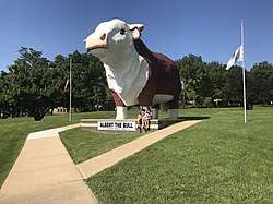 Albert the Bull | |
 Location of Audubon, Iowa | |
| Coordinates: 41°43′13″N 94°55′42″W / 41.72028°N 94.92833°WCoordinates: 41°43′13″N 94°55′42″W / 41.72028°N 94.92833°W | |
| Country |
|
| State |
|
| County | Audubon |
| Incorporated | December 2, 1880 [1] |
| Area[2] | |
| • Total | 1.88 sq mi (4.87 km2) |
| • Land | 1.88 sq mi (4.87 km2) |
| • Water | 0 sq mi (0 km2) |
| Elevation | 1,306 ft (398 m) |
| Population (2010)[3] | |
| • Total | 2,176 |
| • Estimate (2016)[4] | 1,970 |
| • Density | 1,157/sq mi (446.9/km2) |
| Time zone | UTC-6 (Central (CST)) |
| • Summer (DST) | UTC-5 (CDT) |
| ZIP code | 50025 |
| Area code(s) | 712 |
| FIPS code | 19-03655 |
| GNIS feature ID | 0454280 |
Audubon is a city and the county seat in Audubon County, Iowa, United States.[5] The population was 2,176 in the 2010 census, a decline from 2,382 in the 2000 census.[6][7]
History
The city is named for John James Audubon the world-famous ornithologist, artist, and painter.[8]
Audubon was laid out by the Chicago, Rock Island and Pacific Railroad, on September 23, 1878. An auction sale of town lots was held on October 15, 1878 with a total sales of $6,190. The railroad was completed on December 6, 1878 and by December 16, 1878 over fifty houses, a bank, five general stores, one jewelry store, two hotels, one restaurant, three meat markets, three blacksmith shops, one harness shop, one livery stable, two coal yards, two lumber yards, one elevator, three grain dealers, and a school house were built. With the four months of rapid growth in Audubon there was already talk of moving the county seat from Exira which was 13 miles away. In 1879 the railroad built what was to become the county courthouse and leased it to the county for five years free of cost, in case the county seat was moved to Audubon. In the 1879 general election the vote approved the moving of the county seat to Audubon.[9]
Although the railroad was responsible for starting the town, Ethelbert J. Freeman was the driving force behind the growth of Audubon. Having lived in Exira, Freeman was the agent for the sale of the railroad lands and the town lots and was one of the first people to live in Audubon. Already active in county politics, he became the first mayor of Audubon and was prominent in the incorporation of the town in 1880. Freeman was half owner of the Citizens Bank, chief of the fire department, and became the manager of the waterworks built in 1882 and later manager of the electric light plant when it was built in 1891.[9][10]
The first postmaster was Arthur L. Sanborn, appointed February 15, 1879. The town post office contains a mural, Audubon's Trip Down the Ohio and Mississippi – 1820, painted in 1942 by Virginia Snedeker. Federally commissioned murals were produced from 1934 to 1943 in the United States through the Section of Painting and Sculpture, later called the Section of Fine Arts, of the Treasury Department.[11] Robert Hunter was the first school teacher from 1878 to 1879. The school keep growing in size and enrollment and by the fall of 1887 the school had eight school rooms, a teaching staff of 10, and 416 pupils enrolled. Audubon was a well-established city by 1900, and growth slowed after that. In 1915 the city was recorded to have a public library, 9 lawyers, 10 medical professionals, 3 veterinarians, 7 clergymen, 4 bankers and many other businesses.[9]
Audubon has been an RAGBRAI overnight stop in 1986 and 2006.
Geography
Audubon's longitude and latitude coordinates in decimal form are 41.720323, −94.928422.[12]
According to the United States Census Bureau, the city has a total area of 1.88 square miles (4.87 km2), all of it land.[2]
Demographics
| Historical population | |||
|---|---|---|---|
| Census | Pop. | %± | |
| 1880 | 792 | — | |
| 1890 | 1,310 | 65.4% | |
| 1900 | 1,866 | 42.4% | |
| 1910 | 1,923 | 3.1% | |
| 1920 | 2,108 | 9.6% | |
| 1930 | 2,255 | 7.0% | |
| 1940 | 2,409 | 6.8% | |
| 1950 | 2,808 | 16.6% | |
| 1960 | 2,928 | 4.3% | |
| 1970 | 2,907 | −0.7% | |
| 1980 | 2,841 | −2.3% | |
| 1990 | 2,524 | −11.2% | |
| 2000 | 2,382 | −5.6% | |
| 2010 | 2,176 | −8.6% | |
| Est. 2016 | 1,970 | [4] | −9.5% |
| U.S. Decennial Census[13] | |||
2010 census
As of the census[3] of 2010, there were 2,176 people, 961 households, and 586 families residing in the city. The population density was 1,157.4 inhabitants per square mile (446.9/km2). There were 1,106 housing units at an average density of 588.3 per square mile (227.1/km2). The racial makeup of the city was 98.9% White, 0.2% African American, 0.3% Native American, 0.2% Asian, and 0.3% from two or more races. Hispanic or Latino of any race were 0.7% of the population.
There were 961 households of which 26.0% had children under the age of 18 living with them, 48.4% were married couples living together, 8.5% had a female householder with no husband present, 4.1% had a male householder with no wife present, and 39.0% were non-families. 36.6% of all households were made up of individuals and 22% had someone living alone who was 65 years of age or older. The average household size was 2.18 and the average family size was 2.82.
The median age in the city was 47.5 years. 21.9% of residents were under the age of 18; 5.4% were between the ages of 18 and 24; 19.5% were from 25 to 44; 24.6% were from 45 to 64; and 28.5% were 65 years of age or older. The gender makeup of the city was 46.5% male and 53.5% female.
2000 census
As of the census[14] of 2000, there were 2,382 people, 1,035 households, and 646 families residing in the city. The population density was 1,354.2 people per square mile (522.6/km²). There were 1,107 housing units at an average density of 629.4 per square mile (242.8/km²). The racial makeup of the city was 99.33% White, 0.25% African American, and 0.42% from two or more races. Hispanic or Latino of any race were 0.34% of the population.
There were 1,035 households out of which 24.9% had children under the age of 18 living with them, 54.0% were married couples living together, 6.9% had a female householder with no husband present, and 37.5% were non-families. 36.0% of all households were made up of individuals and 23.1% had someone living alone who was 65 years of age or older. The average household size was 2.18 and the average family size was 2.83.
Age spread: 22.8% under the age of 18, 4.9% from 18 to 24, 20.8% from 25 to 44, 20.2% from 45 to 64, and 31.3% who were 65 years of age or older. The median age was 46 years. For every 100 females, there were 82.0 males. For every 100 females age 18 and over, there were 76.9 males.
The median income for a household in the city was $33,068, and the median income for a family was $40,455. Males had a median income of $31,071 versus $19,183 for females. The per capita income for the city was $20,128. About 5.9% of families and 6.7% of the population were below the poverty line, including 6.9% of those under age 18 and 7.1% of those age 65 or over.
Arts and culture
- Annual events
- Celebrated on the last Saturday in April is the John James Audubon festival in honor of the town's namesake.[8]
- Celebrated the first Saturday in August is Audubon's largest celebration OPERATION T-BONE with a variety of events most notably the T-Bone feeders' auction.[8]
- Landmarks and attractions
Audubon is home to a gigantic bull statue, Albert the Bull. The statue is 30 feet tall, weighs 45 tons, and can be seen from US highway 71 even at night (lighted).[8]
Notable people
- William R. Green (1856–1947) U.S. Representative from Iowa's 9th congressional district for nine terms[15]
- Harold R. Kaufman (1926– ) Award-winning American physicist, professor, and patent holder[16]
- Charles Taylor Manatt (1936–2011) Chairman of the Democratic National Committee 1981–85[17][18]
- C. W. McCall is the pseudonym of William Dale Fries, Jr. (1928– ) an advertising executive and singer, best known for the song Convoy.[19] McCall recorded a song about his hometown, "Audubon", in 1975.
See also
References
- ↑ "Audubon, Iowa". City-Data. Retrieved 2011-06-30.
- 1 2 "US Gazetteer files 2010". United States Census Bureau. Archived from the original on January 24, 2012. Retrieved 2012-05-11.
- 1 2 "American FactFinder". United States Census Bureau. Retrieved 2012-05-11.
- 1 2 "Population and Housing Unit Estimates". Retrieved June 9, 2017.
- ↑ "Find a County". National Association of Counties. Archived from the original on May 31, 2011. Retrieved 2011-06-07.
- ↑ "Population & Housing Occupancy Status 2010". United States Census Bureau American FactFinder. Archived from the original on 21 July 2011. Retrieved 2011-06-30.
- ↑ "Data from the 2010 Census". State Data Center of Iowa. Archived from the original on 18 July 2011. Retrieved 2011-06-30.
- 1 2 3 4 "Tourism". Audubon County. Archived from the original on 7 July 2011. Retrieved 2011-06-21.
- 1 2 3 Andrews, H.F. (1915). "History of Audubon county, Iowa; its people, industries, and institutions". B. F. Bowen & company. pp. 267–281. Retrieved 2011-06-30.
- ↑ "List of Incorporated Cities" (PDF). Iowa Secretary of State. Retrieved 2011-06-30.
- ↑ Arnesen, Eric (2007). Encyclopedia of U.S. Labor and Working-Class History. 1. New York: Routledge. p. 1540. ISBN 9780415968263.
- ↑ "US Gazetteer files: 2010, 2000, and 1990". United States Census Bureau. 2011-02-12. Retrieved 2011-04-23.
- ↑ "Census of Population and Housing". Census.gov. Archived from the original on May 12, 2015. Retrieved June 4, 2015.
- ↑ "American FactFinder". United States Census Bureau. Archived from the original on September 11, 2013. Retrieved 2008-01-31.
- ↑ "GREEN, William Raymond". Biographical Directory of the United States Congress. Retrieved 2011-06-30.
- ↑ "Biography: Harold R. Kaufman". AVS Science and Technology. Archived from the original on 19 July 2011. Retrieved 2011-06-30.
- ↑ "History". Taylor Hill Lodge. Retrieved 2011-06-30.
- ↑ Barabak, Mark (July 23, 2011). "Charles T. Manatt, Democratic Party leader and diplomat, dies at 75". Los Angeles Times. Archived from the original on 24 July 2011. Retrieved 2011-07-23.
- ↑ "Biography for Bill Fries". IMDb.com, Inc. Retrieved 2011-06-30.
External links
| Wikimedia Commons has media related to Audubon, Iowa. |
- City tourism page
- City-Data Comprehensive statistical data and more about Audubon
Municipalities and communities of Audubon County, Iowa, United States | ||
|---|---|---|
| Cities | ||
| Townships | ||
| Unincorporated communities | ||