Atmore Municipal Airport
| Atmore Municipal Airport | |||||||||||
|---|---|---|---|---|---|---|---|---|---|---|---|
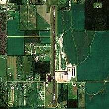 NAIP aerial image, 30 June 2006 | |||||||||||
| Summary | |||||||||||
| Airport type | Public | ||||||||||
| Owner | Atmore, Alabama | ||||||||||
| Serves | Atmore, Alabama | ||||||||||
| Elevation AMSL | 287 ft / 88 m | ||||||||||
| Coordinates | 31°00′58″N 087°26′48″W / 31.01611°N 87.44667°WCoordinates: 31°00′58″N 087°26′48″W / 31.01611°N 87.44667°W | ||||||||||
| Map | |||||||||||
 0R1 Location of airport in Alabama | |||||||||||
| Runways | |||||||||||
| |||||||||||
| Statistics (2017) | |||||||||||
| |||||||||||
Atmore Municipal Airport (FAA LID: 0R1) is a city-owned public-use airport located 3 nautical miles (6 km) east of the central business district of Atmore, a city in Escambia County, Alabama, United States.[1] According to the FAA's National Plan of Integrated Airport Systems for 2009–2013, it is categorized as a general aviation facility.[2]
Facilities and aircraft
Atmore Municipal Airport covers an area of 43 acres (0.07 sq mi; 0.17 km2) which contains one runway designated 18/36 is 5,209 x 80 feet (1,588 x 24 meters) asphalt pavement. For the 12-month period ending February 26, 2007, the airport had 3,870 general aviation aircraft operations.[1] In 2017, the city of Atmore extended the runway length to its current length of 5,209 feet from its previous length of 4,950 feet.
References
- 1 2 3 FAA Airport Master Record for 0R1 (Form 5010 PDF), effective January 5, 2017
- ↑ National Plan of Integrated Airport Systems for 2009–2013: Appendix A: Part 1 (PDF, 1.33 MB) Archived August 6, 2011, at the Wayback Machine.. Federal Aviation Administration. Updated 15 October 2008.
External links
- Coastal Gateway Regional Economic Development Alliance
- Escambia County Industrial Development Authority
- FAA Terminal Procedures for 0R1, effective October 11, 2018
- Resources for this airport:
- FAA airport information for 0R1
- AirNav airport information for 0R1
- FlightAware airport information and live flight tracker
- SkyVector aeronautical chart for 0R1