Atkins, Wisconsin
| Atkins, Wisconsin | |
|---|---|
| Unincorporated community | |
 Atkins, Wisconsin  Atkins, Wisconsin | |
| Coordinates: 45°39′55″N 89°01′23″W / 45.66528°N 89.02306°WCoordinates: 45°39′55″N 89°01′23″W / 45.66528°N 89.02306°W | |
| Country | United States |
| State | Wisconsin |
| County | Forest |
| Elevation | 1,667 ft (508 m) |
| Time zone | UTC-6 (Central (CST)) |
| • Summer (DST) | UTC-5 (CDT) |
| Area code(s) | 715 & 534 |
| GNIS feature ID | 1578675[1] |
Atkins is an unincorporated community in the town of Hiles, Forest County, Wisconsin, United States. Atkins is located on the Canadian National Railway 8.5 miles (13.7 km) northwest of Crandon. The community was most likely named for Hubbard C. Atkins, the superintendent of the Prairie du Chien & La Crosse railroad in the 1880s.[2]
References
- ↑ U.S. Geological Survey Geographic Names Information System: Atkins, Wisconsin
- ↑ Callary, Edward. Place Names of Wisconsin. Madison, WI: University of Wisconsin Press. p. 16. ISBN 978-0-299-30964-0.
Municipalities and communities of Forest County, Wisconsin, United States | ||
|---|---|---|
| City | 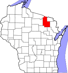 | |
| Towns | ||
| CDPs | ||
| Unincorporated communities | ||
| Indian reservations | ||
| Ghost towns/neighborhoods | ||
| Footnotes | ‡This populated place also has portions in an adjacent county or counties | |
This article is issued from
Wikipedia.
The text is licensed under Creative Commons - Attribution - Sharealike.
Additional terms may apply for the media files.