Argonne (CDP), Wisconsin
| Argonne, Wisconsin | |
|---|---|
| Census-designated place | |
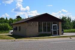 Argonne post office | |
 Argonne, Wisconsin | |
| Coordinates: 45°39′35″N 88°52′45″W / 45.65972°N 88.87917°WCoordinates: 45°39′35″N 88°52′45″W / 45.65972°N 88.87917°W | |
| Country | United States |
| State | Wisconsin |
| County | Forest |
| Area | |
| • Total | 0.556 sq mi (1.44 km2) |
| • Land | 0.556 sq mi (1.44 km2) |
| • Water | 0 sq mi (0 km2) |
| Elevation | 1,640 ft (500 m) |
| Population (2010) | |
| • Total | 160 |
| • Density | 290/sq mi (110/km2) |
| Time zone | UTC-6 (Central (CST)) |
| • Summer (DST) | UTC-5 (CDT) |
| ZIP code | 54511 |
| Area code(s) | 715 & 534 |
| FIPS Code | 55-02600 |
| GNIS feature ID | 1578668[1] |
Argonne is an unincorporated census-designated place in the town of Argonne, Forest County, Wisconsin, United States. Argonne is located at the junction of Wisconsin Highway 32 and Wisconsin Highway 55 6 miles (9.7 km) north of Crandon. Argonne has a post office with ZIP code 54511.[2] The community was established in 1888.[1] As of the 2010 census, its population was 160.[3]
References
- 1 2 U.S. Geological Survey Geographic Names Information System: Argonne (CDP), Wisconsin
- ↑ ZIP Code Lookup Archived June 15, 2011, at the Wayback Machine.
- ↑ "American FactFinder". U.S. Census Bureau. Archived from the original on 23 April 2011. Retrieved 29 March 2011.
Municipalities and communities of Forest County, Wisconsin, United States | ||
|---|---|---|
| City | 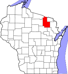 | |
| Towns | ||
| CDPs | ||
| Unincorporated communities | ||
| Indian reservations | ||
| Ghost towns/neighborhoods | ||
| Footnotes | ‡This populated place also has portions in an adjacent county or counties | |
This article is issued from
Wikipedia.
The text is licensed under Creative Commons - Attribution - Sharealike.
Additional terms may apply for the media files.