Assandh
| Assandh असंध | |
|---|---|
| city | |
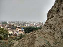 View of Assandh town from the Stupa | |
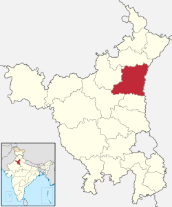
 Assandh Location in Haryana, India  Assandh Assandh (India) | |
| Coordinates: 29°31′N 76°43′E / 29.51°N 76.72°ECoordinates: 29°31′N 76°43′E / 29.51°N 76.72°E | |
| Country |
|
| State | Haryana |
| District | Karnal |
| Population (2001) | |
| • Total | 22,707 |
| Languages | |
| • Official | Hindi |
| Time zone | UTC+5:30 (IST) |
| PIN | 132039 |
| ISO 3166 code | IN-HR |
| Vehicle registration | HR |
| Website |
haryana |
| STD Code 01749, DL Code HR-40 | |
Assandh is a city and a municipal committee in Karnal district in the state of Haryana, India. Assandh is 45 km south-west of Karnal.
History
Early history
Archaeological excavations have revealed Painted Grey Ware,[1] associated with the Vedic people of Iron Age India. Assandh is identified with ancient Āsandīvat,[1][2] a capital of the Kuru Kingdom, which was the first recorded state in ancient India, c. 1200 BCE.[3] Historian Charles Allen has related this town and the Stupa to Asandhimitra, the Chief Queen (Agramahisi) of the Mauryan emperor Ashoka.[4]
Assandh Stupa
The ruins of more-than-2000-year-old nation’s biggest Buddhist Stupa is situated at Assandh.The stupa is 25-metre high and at least 75 metres in diameter raised on an earthen platform. It is built with the help of bricks. This stupa is bigger than the much-famous stupa at Sanchi. According to historians, bricks used to construct this stupa, having a width of more than two-feet, indicate that the history of this monument dates back to more than 2000 years.Therefore, the importance of Assandh in the ancient period can not be ruled out with the presence of the nation’s biggest stupa.
The ruins of this structure is also known as Jarasandh ka Qila/Teela or Jarasandh ka Teela (Fort/Mound of Jarasandh) named after a character of epic Mahabharat, and forms part of the 48 kos parikrama of Kurukshetra.[5]
According to Archaeological Survey of India, this is a Kushan stupa (belongs to Kushan period).[6]
Colonial era
Assandh had a large Muslims population before 1947. After the 1947, muslims were replace with the Sikhs and Punjabi Khatri refugee migrants from Pakistani Punjab.
Modern history
Panipat was the part of District Karnal till 31 October 1989, which was upgraded as a separate District, including Assandh Tehsil of district Karnal. When the District was reformed on 1 January 1992 Assandh Tehsil was excluded from this District.
There is a Gurudwara and Sanatan Dharm Mandir.
Demographics
As of 2001 India census,[7] Assandh had a population of 41,415. Males constitute 54% of the population and females 46%. Assandh has an average literacy rate of 62%, higher than the national average of 59.5%; with 58% of the males and 42% of females literate. 15% of the population is under 6 years of age.
Schools
- Vivekanand Vidya Niketan, Assandh
- MAX International School Assandh
- D.A.V. Public School Assandh
- National Public School Assandh
- JPS Academy Assandh
- Aadarsh Public School Assandh
- Minerva Public School Assandh
- Himalaya Public School Assandh
- Shivalik Public School Assandh
- Sant Joseph Public School Assandh
- MM Public School Assandh
Colleges
- Jeevan Chanan Mahila Mahavidayalaya Assandh
- Jeevan Chanan College of Education Assandh
- Baba fateh singh ji Government College Assandh, Karnal
- Ramrishi private iti Assandh road Salwan (Assandh)pin ,132046.
Politics
Assandh is part of Assandh constituency of the Haryana Vidhan Sabha. The following is the list of MLAs have been elected from this constituency:
- 1952 - Kasturi Lal - INC
- 1977 - Jogi Ram - JNP
- 1982 - Manphool Singh - LKD
- 1987 - Manphool Singh - LKD
- 1991 - Krishan Lal Panwar - JP
- 1996 - Krishan Lal Panwar - SAP
- 2000 - Krishan Lal Panwar - INLD
- 2005 - Raj Rani Poonam - INC
- 2009 - Pt. Zile Ram Sharma - INC
- 2014 - Sardar Bakhshish Singh Virk - BJP
Villages in Assandh Tehsil
- Alawla
- Ardana
- Assandh
- Bahri
- Balla
- Barota
- Balona
- Bassi
- Bhambar Heri
- Bindrala
- Bir Bassi
- Chaugawan
- Chirao
- Chochra
- Danauli
- Dupedi
- Gangatheri
- Golli
- Ichhanpur
- Janni
- Jai Singhpura
- Jalmana
- Jabhala
- Jhimri Khera
- Jundla
- Kaboolpur
- Karsa Chaur
- Kaul
- Khaktor
- Khanda Kheri
- Kheri Naru
- Kheri Sharafali
- Khizarabad
- Kurlan
- Lalain Panghala
- Mardan Heri
- Mor Majra
- Mundh
- Pacca Khera
- Padha
- Phaphrana
- Popran
- Rahara
- Rattak Assandh
- Risalwa
- Ruksana
- Salwan
- Sheikhupura Manchuri
- Thal
- Thari
- Tharwa Majra
- Uplana
- Uplana</ref></ref>
- Rangrutti Khera
References
- 1 2 Prāci-jyotī: Digest of Indological Studies. Kurukshetra University. 1967.
- ↑ Roshen Dalal (2010). Hinduism: An Alphabetical Guide. Penguin Books India. pp. 177–. ISBN 978-0-14-341421-6.
- ↑ M Witzel, Early Sanskritization: Origin and Development of the Kuru state, EJVS vol. 1 no. 4 (1995)
- ↑ Allen, Charles (2012). "16". Ashoka: The Search for India's Lost Emperor. Hachette UK. ISBN 1408703882.
- ↑ "Kurukshetra map". kurukshetra.nic.in. Retrieved 24 July 2016.
- ↑ http://asi.nic.in/asi_monu_alphalist_haryana.asp
- ↑ "Census of India 2001: Data from the 2001 Census, including cities, villages and towns (Provisional)". Census Commission of India. Archived from the original on 2004-06-16. Retrieved 2008-11-01.