Askov, Minnesota
| Askov, Minnesota | |
|---|---|
| City | |
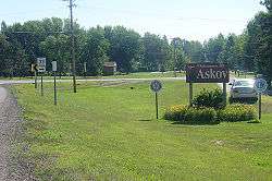 Askov, Minnesota; July 2007 | |
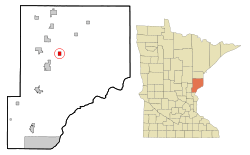 Location of the city of Askov within Pine County, Minnesota | |
| Coordinates: 46°11′16″N 92°46′51″W / 46.18778°N 92.78083°W | |
| Country | United States |
| State | Minnesota |
| County | Pine |
| Incorporated | April 25, 1918[1] |
| Government | |
| • Mayor | Paul Paulsen[2] |
| Area[3] | |
| • Total | 1.26 sq mi (3.26 km2) |
| • Land | 1.26 sq mi (3.26 km2) |
| • Water | 0 sq mi (0 km2) |
| Elevation | 1,168 ft (356 m) |
| Population (2010)[4] | |
| • Total | 364 |
| • Estimate (2016)[5] | 347 |
| • Density | 290/sq mi (110/km2) |
| • Demonym | Askovian |
| Time zone | UTC-6 (Central (CST)) |
| • Summer (DST) | UTC-5 (CDT) |
| ZIP code | 55704 |
| Area code(s) | 320 |
| FIPS code | 27-02548[6] |
| GNIS feature ID | 0639478[7] |
Askov is a city in Pine County, Minnesota, United States. The population was 364 at the 2010 census.[8]
Minnesota State Highway 23 serves as a main route in the community, and Interstate 35 is nearby. It is located in a region called East Central Minnesota.
History
Originally the Village of Partridge, it was a Great Northern Railway stop; its post office began as Partridge, 1889–1909, before changing to Askov. Most of the village was destroyed in the 1894 Hinckley fire. In the re-building, the new village was founded by the Danish Peoples Society in 1906. The name "Askov" means "ash forest". The new village was incorporated on April 25, 1918, and officially separated from the township as the City of Askov on April 8, 1921. Consequently, nearly all the streets in Askov have Danish names.
The fashion brand Askov Finlayson was named after this city and neighboring Finlayson, Minnesota, which share a freeway exit on I-35.[9]
Geography
According to the United States Census Bureau, the city has a total area of 1.26 square miles (3.26 km2), all land.[3]
The Kettle River and Partridge Creek both flow nearby. Banning State Park is also nearby.
Demographics
| Historical population | |||
|---|---|---|---|
| Census | Pop. | %± | |
| 1920 | 242 | — | |
| 1930 | 298 | 23.1% | |
| 1940 | 312 | 4.7% | |
| 1950 | 387 | 24.0% | |
| 1960 | 331 | −14.5% | |
| 1970 | 287 | −13.3% | |
| 1980 | 350 | 22.0% | |
| 1990 | 343 | −2.0% | |
| 2000 | 368 | 7.3% | |
| 2010 | 364 | −1.1% | |
| Est. 2016 | 347 | [5] | −4.7% |
| U.S. Decennial Census | |||
2010 census
As of the census[4] of 2010, there were 364 people, 171 households, and 88 families residing in the city. The population density was 288.9 inhabitants per square mile (111.5/km2). There were 188 housing units at an average density of 149.2 per square mile (57.6/km2). The racial makeup of the city was 97.3% White, 0.3% Native American, 0.3% Asian, and 2.2% from two or more races. Hispanic or Latino of any race were 1.4% of the population.
There were 171 households of which 24.0% had children under the age of 18 living with them, 36.8% were married couples living together, 8.8% had a female householder with no husband present, 5.8% had a male householder with no wife present, and 48.5% were non-families. 41.5% of all households were made up of individuals and 21.7% had someone living alone who was 65 years of age or older. The average household size was 2.13 and the average family size was 2.88.
The median age in the city was 41 years. 21.7% of residents were under the age of 18; 5% were between the ages of 18 and 24; 28% were from 25 to 44; 25.5% were from 45 to 64; and 19.8% were 65 years of age or older. The gender makeup of the city was 47.0% male and 53.0% female.
2000 census
As of the census[6] of 2000, there were 368 people, 165 households, and 92 families residing in the city. The population density was 288.3 people per square mile (111.0/km²). There were 181 housing units at an average density of 141.8 per square mile (54.6/km²). The racial makeup of the city was 95.92% White, 0.27% African American, 1.63% Native American, 0.54% Asian, 0.54% from other races, and 1.09% from two or more races.
There were 165 households out of which 29.1% had children under the age of 18 living with them, 40.6% were married couples living together, 9.7% had a female householder with no husband present, and 44.2% were non-families. 40.0% of all households were made up of individuals and 24.8% had someone living alone who was 65 years of age or older. The average household size was 2.23 and the average family size was 3.05.
In the city, the population was spread out with 25.8% under the age of 18, 11.1% from 18 to 24, 22.0% from 25 to 44, 20.9% from 45 to 64, and 20.1% who were 65 years of age or older. The median age was 38 years. For every 100 females, there were 101.1 males. For every 100 females age 18 and over, there were 89.6 males.
The median income for a household in the city was $28,472, and the median income for a family was $36,250. Males had a median income of $27,375 versus $24,375 for females. The per capita income for the city was $14,583. About 5.3% of families and 9.2% of the population were below the poverty line, including 6.3% of those under age 18 and 16.7% of those age 65 or over.
Tradition
Askov is the former "Rutabaga Capital of the World" and was a hub of rutabaga cultivation until A. Henriksen's rutabaga warehouse operation burned in the 1970s. The city of Askov is currently home of the annual Askov Fair and Rutabaga Festival, held during the fourth weekend of August.
Notable people
Askov is also the hometown of Minneapolis Lakers star and NBA Hall of Famer Vern Mikkelsen and was the residence of former Minnesota governor Hjalmar Petersen.[10] L. C. Pedersen, businessman and politician, also lived in Askov.[11]
References
- ↑ http://www.lakesnwoods.com/Askov.htm
- ↑ http://www.co.pine.mn.us/index.asp?Type=B_BASIC&SEC=%7B4BE2F27C-B77C-4F0A-9BE6-BFAFD400FEBF%7D
- 1 2 "US Gazetteer files 2010". United States Census Bureau. Archived from the original on 2012-01-24. Retrieved 2012-11-13.
- 1 2 "American FactFinder". United States Census Bureau. Retrieved 2012-11-13.
- 1 2 "Population and Housing Unit Estimates". Retrieved June 9, 2017.
- 1 2 "American FactFinder". United States Census Bureau. Archived from the original on 2013-09-11. Retrieved 2008-01-31.
- ↑ "US Board on Geographic Names". United States Geological Survey. 2007-10-25. Retrieved 2008-01-31.
- ↑ "2010 Census Redistricting Data (Public Law 94-171) Summary File". American FactFinder. U.S. Census Bureau, 2010 Census. Archived from the original on 26 July 2011. Retrieved 23 April 2011.
- ↑ http://www.mr-mag.com/askov-finlayson-the-trifecta/
- ↑ Minnesota Legislators Past and Present-Hjalmar Petersen
- ↑ Minnesota Legislators Past and Present-L.C. Pedersen
External links
- Askov American, local newspaper
- East Central Schools website
- Askov Rutabaga Festival
Municipalities and communities of Pine County, Minnesota, United States | ||
|---|---|---|
| Cities |  | |
| Townships | ||
| Unincorporated communities | ||
| Ghost towns | ||
| Indian reservation | ||
Coordinates: 46°11′12″N 92°46′57″W / 46.18667°N 92.78250°W