Cloverdale, Minnesota
| Cloverdale, Minnesota | |
|---|---|
| Unincorporated community | |
 Cloverdale, Minnesota Location of the community of Cloverdale within Arlone Township, Pine County  Cloverdale, Minnesota Cloverdale, Minnesota (the US) | |
| Coordinates: 46°00′44″N 92°44′24″W / 46.01222°N 92.74000°WCoordinates: 46°00′44″N 92°44′24″W / 46.01222°N 92.74000°W | |
| Country | United States |
| State | Minnesota |
| County | Pine |
| Township | Arlone Township |
| Elevation | 978 ft (298 m) |
| Population | |
| • Total | 40 |
| Time zone | UTC-6 (Central (CST)) |
| • Summer (DST) | UTC-5 (CDT) |
| ZIP code | 55037 |
| Area code(s) | 320 |
| GNIS feature ID | 641355[1] |
Cloverdale is an unincorporated community in Arlone Township, Pine County, Minnesota, United States.
State Highway 48 (MN 48) and Pine County Road 21 are two of the main routes in the community.
Cloverdale is located ten miles east of Hinckley; and 18 miles west of Danbury, Wisconsin.
Bear Creek flows through the community.
St. Croix State Park and St. Croix State Forest are immediately east of Cloverdale.
The community was originally known as Turpville.
References
- Rand McNally Road Atlas – 2007 edition – Minnesota entry
- Official State of Minnesota Highway Map – 2011/2012 edition
Municipalities and communities of Pine County, Minnesota, United States | ||
|---|---|---|
| Cities | 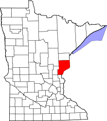 | |
| Townships | ||
| Unincorporated communities | ||
| Ghost towns | ||
| Indian reservation | ||
This article is issued from
Wikipedia.
The text is licensed under Creative Commons - Attribution - Sharealike.
Additional terms may apply for the media files.