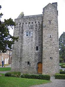
Ashtown, Dublin

Ashtown (Irish: Baile an Áisigh) is a townland in the civil parish of Castleknock and falls into the postal districts of Dublin 15, with some addresses falling into the Dublin 7 postal district. It is bounded roughly by the townlands of Castleknock to the west, Cabra to the east and by Finglas to the north-east and Dunsink to the north-west. It is situated by the Royal Canal, near the Navan Road. The Phoenix Park is also nearby, its Ashtown Gate entrance about 500 metres south of the railway station. The "Belleville" and "Paddock" housing estates lie within the territory of Dublin City Council; the remainder of the townland's 278 acres are within Fingal. The suburb has a population of 13,209 inhabitants as of 2016.[1]
Transport
The Dublin-Sligo railway passes through the area and it is served by Ashtown railway station, which opened on 1 August 1902.[3] Stopping at Ashtown is the Western Commuter service, which runs frequently between Maynooth and Pearse Station in the city centre. The area is also served by the 120 Dublin Bus route, which terminates at the railway station, and by the 37, 38, 39 and 70 routes, which pass nearby on the Navan Road.
LUAS (light rail / tram) will be available to and from nearby Broombridge from approximately December 2017.
Sport
The grounds of St Oliver Plunketts/Eoghan Ruadh GAA are located in Martin Savage Park, which is just to the south of the railway line and runs along it. Phoenix FC, formerly known as Kinvara Ards, also use this park for their youth teams, but have used a football complex in Scribblestown for their senior team since their merger with Ashtown Villa in 2006.
References
- ↑ https://www.citypopulation.de/php/ireland-dublin.php From Census 2016 - includes population of electoral divisions: Ashtown A & B
- ↑ Teagasc. "Ashtown Food Research Centre". Teagasc. Retrieved 11 May 2018.
- ↑ "Ashtown station" (PDF). Railscot - Irish Railways. Archived (PDF) from the original on 26 September 2007. Retrieved 2007-08-31.
Coordinates: 53°22′31″N 6°19′58″W / 53.375369°N 6.332644°W