Arua
| Arua | |
|---|---|
| Motto(s): Peace, Justice & Prudence | |
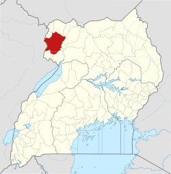
 Arua Location in Uganda | |
| Coordinates: 3°02′18″N 30°54′39″E / 3.03833°N 30.91083°E | |
| Country |
|
| Region | Northern Region |
| Sub-region | West Nile sub-region |
| District | Arua District |
| Government | |
| • Mayor | Charles Asiki |
| Population (2014 Census) | |
| • Total | 62,657[1] |
| Area code(s) | 0476 |
| Website | www.arua.go.ug |
| Sources: Google Maps[2] | |
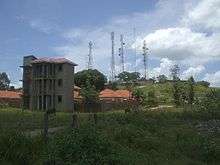
Arua is a town and commercial centre within the Arua District in the Northern Region of Uganda.
Location
Arua is approximately 440 kilometres (270 mi), by road, north-west of Kampala, the capital and largest city of Uganda,[3] and approximately 195 kilometres (121 mi), by road, west of Gulu, the largest town in the Northern Region.[4]
Overview
Arua is an important base for non-governmental organizations working in the West Nile sub-region or serving Western Equatoria in South Sudan and the northeastern Democratic Republic of the Congo. It became an important commercial supply centre and transport route[5] when the Yei–Juba road opened, enabling supplies to come into Juba from the south on the Kaya Highway instead of through Khartoum from the north.
Transport
A branch of the Uganda Railways was extended to Arua sometime after 1964,[6] but there has been no passenger rail service in Uganda for many years.[7]
The Vurra–Arua–Koboko–Oraba Road passes through town, in a south/north direction.[8]
The city is served by Arua Airport, which has scheduled air service.[9]
Population
The 2002 national census estimated the population of Arua Town at 43,930. In 2010, the Uganda Bureau of Statistics (UBOS) estimated the population to be 57,500. In 2011, UBOS estimated the population at 59,400.[10] In August 2014, the national population census put the population at 62,657.[1]
Climate
| Climate data for Arua (1961–1990) | |||||||||||||
|---|---|---|---|---|---|---|---|---|---|---|---|---|---|
| Month | Jan | Feb | Mar | Apr | May | Jun | Jul | Aug | Sep | Oct | Nov | Dec | Year |
| Record high °C (°F) | 34.4 (93.9) |
36.1 (97) |
37.8 (100) |
35.6 (96.1) |
33.3 (91.9) |
30.6 (87.1) |
30.0 (86) |
31.1 (88) |
30.6 (87.1) |
32.4 (90.3) |
33.3 (91.9) |
33.6 (92.5) |
37.8 (100) |
| Average high °C (°F) | 30.5 (86.9) |
31.1 (88) |
30.2 (86.4) |
28.8 (83.8) |
27.9 (82.2) |
27.1 (80.8) |
26.1 (79) |
26.3 (79.3) |
27.2 (81) |
27.9 (82.2) |
28.4 (83.1) |
29.1 (84.4) |
28.4 (83.1) |
| Average low °C (°F) | 17.4 (63.3) |
18.0 (64.4) |
18.3 (64.9) |
18.0 (64.4) |
17.5 (63.5) |
16.9 (62.4) |
16.4 (61.5) |
16.3 (61.3) |
16.5 (61.7) |
16.9 (62.4) |
17.2 (63) |
17.0 (62.6) |
17.2 (63) |
| Record low °C (°F) | 12.8 (55) |
11.1 (52) |
13.9 (57) |
13.9 (57) |
14.4 (57.9) |
13.2 (55.8) |
11.7 (53.1) |
11.1 (52) |
12.2 (54) |
14.1 (57.4) |
14.4 (57.9) |
12.8 (55) |
11.1 (52) |
| Average precipitation mm (inches) | 17.5 (0.689) |
36.6 (1.441) |
90.7 (3.571) |
120.4 (4.74) |
127.6 (5.024) |
146.4 (5.764) |
154.5 (6.083) |
216.9 (8.539) |
173.0 (6.811) |
209.5 (8.248) |
125.1 (4.925) |
29.8 (1.173) |
1,448 (57.008) |
| Average precipitation days (≥ 1.0 mm) | 1.4 | 3.0 | 7.0 | 9.0 | 8.7 | 8.5 | 11.3 | 12.6 | 11.5 | 13.8 | 9.7 | 3.1 | 99.6 |
| Average relative humidity (%) (at 14:00) | 38 | 36 | 44 | 56 | 60 | 63 | 67 | 66 | 62 | 60 | 53 | 46 | 54 |
| Source #1: World Meteorological Organization[11] | |||||||||||||
| Source #2: Deutscher Wetterdienst (extremes and humidity)[12] | |||||||||||||
Activities
Administrative activities
The following administrations are seated in Arua:
- headquarters of Arua District
- headquarters of the Roman Catholic Diocese of Arua and the Church of Uganda's Madi West Nile Diocese
- offices of the Arua Town Council
Other business and educational activities
- a branch of PostBank Uganda
- Arua Campus of Muni University in Muni, Oluko Sub-County
- a campus of the Islamic University in Uganda
- an office of the National Social Security Fund
- Arua Campus of the Makerere University Business School
- Arua Campus of Uganda Christian University in Ringili at St. Paul's Theological College
- Arua Campus of Bugema Universitywww.bugemauniv.ac.ug
- Arua central market
- Arua Currency Center, a currency storage and processing facility, owned and operated by the Bank of Uganda, Uganda's central bank.[13]
- Arua Hospital, a 128-bed public, regional referral hospital administered by the Uganda Ministry of Health
- main campus of Muni University, the sixth public university established by the government of Uganda
- Ragem Beach
Media
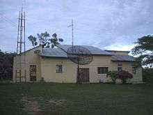
Analog broadcasts, which originate from Kampala, include WBS TV, UBC TV, and NTV. In early 2014, MBC 2 was aired in Arua as a test broadcast to pave way for Vision Group's Urban TV.[14]
Voice of Life, a Church of Uganda-founded radio station, has pioneered FM broadcasting in Arua since 1997.[15]
See also
References
- 1 2 UBOS (27 August 2014). "The Population of The Regions of the Republic of Uganda And All Cities And Towns of More Than 15,000 Inhabitants". Citypopulation.de Quoting Uganda Bureau of Statistics (UBOS). Retrieved 22 February 2015.
- ↑ Google (2 July 2015). "Location of Arua at Google Maps" (Map). Google Maps. Google. Retrieved 2 July 2015.
- ↑ "Road Distance Between Kampala And Arua With Map". Globefeed.com. Retrieved 2 June 2014.
- ↑ "Map Showing Arua And Gulu With Distance Marker". Globefed.com. Retrieved 2 June 2014.
- ↑ BBC (14 November 2006). "Uganda's Booming Border Town". BBC News. Retrieved 2 June 2014.
- ↑ "Nairobi Railway Museum". Archived from the original on 26 January 2010. Retrieved 25 January 2010.
- ↑ "Uganda Travel Advice and Advisories (Government of Canada)". Retrieved 25 January 2010.
- ↑ USHMU (11 May 2012). "Use The Road for Making Wealth – President Urges West Nile People". Uganda State House Media Unit (USHMU). Retrieved 1 July 2015.
- ↑ Eagle Air schedule Retrieved 4 April 2016
- ↑ UBOS. "Estimated Population of Arua In 2002, 2010 And 2011" (PDF). Uganda Bureau of Statistics (UBOS). Archived from the original (PDF) on 7 July 2014. Retrieved 2 June 2014.
- ↑ "World Weather Information Service – Arua". World Meteorological Organization. Retrieved 1 September 2016.
- ↑ "Klimatafel von Arua / Uganda" (PDF). Baseline climate means (1961-1990) from stations all over the world (in German). Deutscher Wetterdienst. Retrieved 1 September 2016.
- ↑ BOU. "Currency Centers: Arua Currency Center". Bank of Uganda. Retrieved 2 June 2014.
- ↑ Staff, Writer (28 March 2014). "Urban TV's Faith Ariho Promoted?". Bigeye.ug. Retrieved 2 June 2014.
- ↑ Voice of Life - Arua
External links
| Wikivoyage has a travel guide for Arua. |
Capital: Arua | ||
| Counties and sub-counties |
|  |
| Towns and villages | ||
| Economy |
| |
| Energy |
| |
| Notable landmarks |
| |
| Education | ||
| Transport |
| |
| Health | ||
| Notable people |
| |