Arrondissement of Segré
| Segré | |
|---|---|
| Arrondissement | |
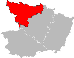 Location of the arrondissement in Maine-et-Loire | |
| Country | France |
| Region | Pays de la Loire |
| Department | Maine-et-Loire |
| Communes | 28 |
| Subprefecture | Segré-en-Anjou Bleu |
| Area¹ | |
| • Total | 1,378 km2 (532 sq mi) |
| Population (2013) | |
| • Total | 62,689 |
| • Density | 45/km2 (120/sq mi) |
| ¹ French Land Register data, which exclude lakes, ponds, and glaciers larger than 1 km² as well as the estuaries of rivers. | |
The arrondissement of Segré is an arrondissement of France in the Maine-et-Loire department in the Pays de la Loire region. Since the January 2017 reorganization of the arrondissements of Maine-et-Loire, it has 28 communes.[1]
Composition
Cantons
The cantons of the arrondissement of Segré are:
Communes
The communes of the arrondissement of Segré, and their INSEE codes, are:
- Angrie (49008)
- Armaillé (49010)
- Bécon-les-Granits (49026)
- Bouillé-Ménard (49036)
- Bourg-l'Évêque (49038)
- Candé (49054)
- Carbay (49056)
- Challain-la-Potherie (49061)
- Chambellay (49064)
- Chazé-sur-Argos (49089)
- Chenillé-Champteussé (49067)
- Châteauneuf-sur-Sarthe (49080)
- Erdre-en-Anjou (49367)
- Grez-Neuville (49155)
- Les Hauts d'Anjou (49065)
- La Jaille-Yvon (49161)
- Juvardeil (49170)
- Le Lion-d'Angers (49176)
- Loiré (49178)
- Miré (49205)
- Montreuil-sur-Maine (49217)
- Ombrée d'Anjou (49248)
- Saint-Augustin-des-Bois (49266)
- Saint-Sigismond (49321)
- Sceaux-d'Anjou (49330)
- Segré-en-Anjou Bleu (49331)
- Thorigné-d'Anjou (49344)
- Val d'Erdre-Auxence (49183)
References
- ↑ "Arrêté préfectoral, 27 December 2016" (PDF). Retrieved 2017-08-04.
External links
This article is issued from
Wikipedia.
The text is licensed under Creative Commons - Attribution - Sharealike.
Additional terms may apply for the media files.