Arkansas Highway 84
| ||||
|---|---|---|---|---|
 | ||||
| Route information | ||||
| Maintained by ArDOT | ||||
| Existed | 1926 – present | |||
| Section 1 | ||||
| Length | 85.8 mi[1][2][3][4] (138.1 km) | |||
| West end |
| |||
| East end |
| |||
| Section 2 | ||||
| Length | 3.7 mi[5] (6.0 km) | |||
| West end |
| |||
| East end |
| |||
| Highway system | ||||
| ||||

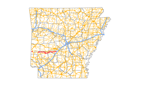
Arkansas Highway 84 (AR 84, Hwy. 84) is a designation for two state highways in west Arkansas. The western segment is 3.7 miles (6.0 km) long[5] and travels from County Road 14 (CR 14) in Bogg Springs and heads east to U.S. Route 59 and U.S. Route 71 (US 59/US 71) before terminating. The eastern segment is 85.8 miles long[1][2][3][4] and travels from US 278 in Umpire to U.S. 270B in Malvern.
Major intersections
Western segment
The entire route is in Polk County.
| Location | mi[5] | km | Destinations | Notes | |
|---|---|---|---|---|---|
| Bogg Springs | 0.0 | 0.0 | Western terminus | ||
| | 3.7 | 6.0 | Eastern terminus | ||
| 1.000 mi = 1.609 km; 1.000 km = 0.621 mi | |||||
Eastern segment
| County | Location | mi[1][2][3][4] | km | Destinations | Notes |
|---|---|---|---|---|---|
| Howard | Umpire | 0.0 | 0.0 | Western terminus | |
| Athens | 6.0 | 9.7 | Eastern terminus of AR 246 | ||
| Pike | Langley | 14.0 | 22.5 | ||
| Salem | 27.3 | 43.9 | West end of concurrency with US 70/AR 27 | ||
| Kirby | 31.9 | 51.3 | East end of concurrency with US 70/AR 27 | ||
| | 41.1 | 66.1 | West end of concurrency with AR 8 | ||
| Clark | Amity | 42.7 | 68.7 | East end of concurrency with AR 8 | |
| 42.9 | 69.0 | Eastern terminus of AR 182 | |||
| | 48.0 | 77.2 | Northern terminus of AR 346 | ||
| Hot Spring | Point Cedar | 55.5 | 89.3 | Southern terminus of AR 347 | |
| Bismarck | 64.5 | 103.8 | |||
| De Roche | 71.4 | 114.9 | West end of concurrency with AR 128 | ||
| | 72.4 | 116.5 | East end of concurrency with AR 128 | ||
| Social Hill | 79.6 | 128.1 | I-30 exit 91 | ||
| Malvern | 85.5 | 137.6 | Southern terminus of AR 171 | ||
| 85.6 | 137.8 | I-30 exit 97 | |||
| 85.8 | 138.1 | Eastern terminus | |||
1.000 mi = 1.609 km; 1.000 km = 0.621 mi
| |||||
See also
References
- 1 2 3 Arkansas State Highway and Transportation Department. AHTD Howard County map Retrieved on August 14, 2017.
- 1 2 3 Arkansas State Highway and Transportation Department. AHTD Pike County map Retrieved on August 14, 2017.
- 1 2 3 Arkansas State Highway and Transportation Department. AHTD Clark County map Retrieved on August 14, 2017.
- 1 2 3 Arkansas State Highway and Transportation Department. AHTD Hot Spring County map Retrieved on August 14, 2017.
- 1 2 3 Arkansas State Highway and Transportation Department. AHTD Polk County map Retrieved on August 13, 2017.
External links
![]()
This article is issued from
Wikipedia.
The text is licensed under Creative Commons - Attribution - Sharealike.
Additional terms may apply for the media files.