Arkansas Highway 321
| ||||
|---|---|---|---|---|
 | ||||
| Route information | ||||
| Maintained by ArDOT | ||||
| Section 1 | ||||
| Length | 11.20 mi[1] (18.02 km) | |||
| South end |
| |||
| North end |
| |||
| Section 2 | ||||
| Length | 3.79 mi[1] (6.10 km) | |||
| South end |
| |||
| North end |
| |||
| Location | ||||
| Counties | Lonoke, White | |||
| Highway system | ||||
| ||||

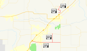
Highway 321 (AR 321, Ark. 321, Hwy. 321) is a designation for two north–south state highways in central Arkansas. One route of 11.20 miles (18.02 km) runs from Highway 5/Highway 367 in Cabot north to Highway 38 east of Austin.[2] A second route of 3.79 miles (6.10 km) begins at AR 31 north of Beebe and runs north to Highway 267.[3]
Route description
Cabot to Austin
Highway 321 begins near an exit from US 67/US 167 at Highway 5 and Highway 367 in Cabot. The route intersects Highway 89 in south Cabot before exiting the city and running due east. Near Oak Grove the route turns due north, with Highway 321 Spur (AR 321S) continuing east to Highway 31. A 2010 study of annual average daily traffic (AADT) by the Arkansas State Highway and Transportation Department (AHTD) reveals that about 19,000 vehicles per day (VPD) use the route between its southern terminus and Highway 89/Highway 367, with the traffic count dropping to 7,000 VPD between that junction and the Cabot city limits. Traffic counts continue around 2,500 VPD until the Highway 321S junction, then drop to 2,100 VPD for the remainder of the route.[1]
Beebe to Essex
Highway 321 begins north of Beebe at Highway 31. The route runs north, having a junction with Highway 321 Spur and passing through Essex. The highway continues north and terminates at Highway 267. An AHTD traffic count from 2010 reveals that the average annual daily traffic never exceeds 640 vehicles per day anywhere on the route.[1]
Major intersections
| County | Location | mi[1] | km | Destinations | Notes | ||
|---|---|---|---|---|---|---|---|
| Lonoke | Cabot | 0.00 | 0.00 | Southern terminus | |||
| 3.24 | 5.21 | ||||||
| | 7.75 | 12.47 | |||||
| | 11.20 | 18.02 | Northern terminus | ||||
| Gap in route | |||||||
| White | | 0.00 | 0.00 | ||||
| | 2.41 | 3.88 | |||||
| | 3.79 | 6.10 | Northern terminus | ||||
| 1.000 mi = 1.609 km; 1.000 km = 0.621 mi | |||||||
Special routes
Lonoke County spur
| |
|---|---|
| Location | Lonoke County |
| Length | 3.15 mi[1] (5.07 km) |
Highway 321 Spur (AR 321S, Ark. 321S, and Hwy. 321S) is an east–west state highway spur route in Lonoke County. The route of 3.15 miles (5.07 km) serves as a connector between Highway 321 and Highway 31.[2]
Major intersections
The entire route is in Lonoke County.
| Location | mi[1] | km | Destinations | Notes | |
|---|---|---|---|---|---|
| | 0.00 | 0.00 | Western terminus | ||
| | 3.15 | 5.07 | Eastern terminus | ||
| 1.000 mi = 1.609 km; 1.000 km = 0.621 mi | |||||
White County spur
| |
|---|---|
| Location | White County |
| Length | 0.35 mi[1] (0.56 km) |
Highway 321 Spur (AR 321S, Ark. 321S, and Hwy. 321S) is an east–west state highway spur route in White County. The route of 0.35 miles (0.56 km) serves as a short connector between Highway 321 and Highway 31.[3]
Major intersections
The entire route is in White County.
| Location | mi[1] | km | Destinations | Notes | |
|---|---|---|---|---|---|
| | 0.00 | 0.00 | Eastern terminus | ||
| | 0.35 | 0.56 | Western terminus | ||
| 1.000 mi = 1.609 km; 1.000 km = 0.621 mi | |||||
See also
References
- 1 2 3 4 5 6 7 8 9 Planning and Research Division (March 28, 2012). "Arkansas Road Log Database". Arkansas State Highway and Transportation Department. Archived from the original (MBD) on June 23, 2011. Retrieved April 13, 2012.
- 1 2 General Highway Map, Lonoke County, Arkansas (PDF) (Map). 1:62500. Cartography by Planning and Research Division. Arkansas State Highway and Transportation Department. 2011. Retrieved March 13, 2012.
- 1 2 General Highway Map, White County, Arkansas (PDF) (Map). 1:62500. Cartography by Planning and Research Division. Arkansas State Highway and Transportation Department. 2008. Retrieved March 13, 2012.
External links
Route map:
![]()