Arkansas Highway 190
| ||||
|---|---|---|---|---|
 | ||||
| Route information | ||||
| Maintained by ArDOT | ||||
| Existed | June 23, 1965[1] – present | |||
| Section 1 | ||||
| Length | 4.48 mi[2] (7.21 km) | |||
| West end |
| |||
| East end |
| |||
| Section 2 | ||||
| Length | 6.30 mi[2] (10.14 km) | |||
| West end |
| |||
| East end |
| |||
| Section 3 | ||||
| Length | 6.70 mi[2] (10.78 km) | |||
| West end |
| |||
| East end | Jefferson County line | |||
| Section 4 | ||||
| Length | 9.10 mi[2] (14.65 km) | |||
| West end | Southeast Arkansas Community Correction Center in Pine Bluff | |||
| East end |
| |||
| Location | ||||
| Counties | Saline, Grant, Jefferson | |||
| Highway system | ||||
| ||||

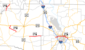
Highway 190 (AR 190, Ark. 190, and Hwy. 190) is a designation for four state highways in Arkansas. The northernmost segment of 4.48 miles (7.21 km) runs from AR 291 in Tull to AR 35.[2] A segment in western Grant County of 6.30 miles (10.14 km) runs east from U.S. Route 270 in Prattsville to Arkansas Highway 46.[3] In eastern Grant County, AR 190 begins at AR 35 and runs east to Jefferson County as the Princeton Pike. A fourth segment runs 9.10 miles (14.65 km), serving as a major east-west street across downtown Pine Bluff.[4]
History
Highway 190 was created by the Arkansas State Highway Commission on June 23, 1965 as a short connection between US 170 and Highway 291.[1] It was extended east to Highway 46 the following month.[5]
Major intersections
Mile markers reset at some concurrencies.
| County | Location | mi[2] | km | Destinations | Notes | ||
|---|---|---|---|---|---|---|---|
| Saline | | 0.00 | 0.00 | Eastern terminus | |||
| Grant | Tull | 4.48 | 7.21 | Highway continues as | Western terminus | ||
| Gap in route | |||||||
| Prattsville | 0.00 | 0.00 | Western terminus | ||||
| | 1.58 | 2.54 | |||||
| | 6.30 | 10.14 | Eastern terminus | ||||
| Gap in route | |||||||
| | 0.00 | 0.00 | Western terminus | ||||
| Grant–Jefferson county line | | 6.70 | 10.78 | End state maintenance | Eastern terminus | ||
| Gap in route | |||||||
| Jefferson | Pine Bluff | 0.00 | 0.00 | Southeast Arkansas Community Correction Center | Western terminus | ||
| 9.10 | 14.65 | Eastern terminus | |||||
1.000 mi = 1.609 km; 1.000 km = 0.621 mi
| |||||||
See also
References
- 1 2 "Minutes" & 1953–69, p. 670.
- 1 2 3 4 5 6 System Information and Research Division (2014). "Arkansas Road Log Database" (MDB). Arkansas State Highway and Transportation Department. Retrieved March 27, 2016.
- ↑ Route and Section Map - Grant County, Arkansas (PDF) (Map). Arkansas State Highway and Transportation Department. Retrieved April 3, 2011.
- ↑ Route and Section Map - Jefferson County, Arkansas (PDF) (Map). Arkansas State Highway and Transportation Department. Retrieved April 3, 2011.
- ↑ "Minutes" & 1953–69, p. 692.
- "Minutes of the Meeting" (PDF). Arkansas State Highway Commission. 1953–1969. Retrieved December 4, 2016.
External links
Route map:
![]()