Arkansas Highway 100
| ||||
|---|---|---|---|---|
 | ||||
| Route information | ||||
| Maintained by ArDOT | ||||
| Existed | December 1, 1987[1] – present | |||
| Section 1 | ||||
| Length | 8.72 mi[2] (14.03 km) | |||
| West end |
| |||
| East end |
| |||
| Section 2 | ||||
| Length | 1.61 mi[2] (2.59 km) | |||
| West end |
| |||
| East end |
| |||
| Location | ||||
| Counties | Pulaski | |||
| Highway system | ||||
| ||||

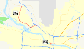
Highway 100 (AR 100, Ark. 100, and Hwy. 100) is a designation for two state highways in Central Arkansas.
Description
One route of 8.72 miles (14.03 km) begins at Highway 365 and runs southeast through Maumelle to Interstate 40 (I-40). A second route of 1.61 miles (2.59 km) in North Little Rock begins at Highway 365 and runs east along the Arkansas River as Riverside Drive to US Highway 70 (US 70). Both routes were designated in 1987 and are maintained by the Arkansas Department of Transportation (ArDOT).
History
The Highway 100 designation was created at the request of the mayor of North Little Rock, who planned to construct Riverside Drive between Rose City and Locust Street, and desired inclusion in the state highway system.[3] The Arkansas State Highway Commission agreed to an alignment in 1965, but the road was not completed for over 20 years. The designation was officially assigned on December 1, 1987, following completion of Riverside Drive between I-30 and Pike Avenue.[1] The highway was extended east to US 70 on May 13, 1998.[4]
A second segment was created on May 6, 1987 along Maumelle Boulevard in response to the population growth of Maumelle.[5] The route was extended along Crystal Hill Road to I-40 on August 11, 1993, at the request of concerned citizens, members of the Arkansas General Assembly, and the Pulaski County Judge. The extension was in exchange for removing a segment of Highway 176 near Camp Joseph T. Robinson.[6]
Major intersections
The entire route is in Pulaski County.
| Location | mi | km | Destinations | Notes | |||
|---|---|---|---|---|---|---|---|
| | 0.00 | 0.00 | Western terminus | ||||
| North Little Rock | 6.86 | 11.04 | I-430 exit 12 | ||||
| | 8.72 | 14.03 | Eastern terminus, I-40 exit 148 | ||||
| Gap in route | |||||||
| North Little Rock | 0.00 | 0.00 | Western terminus, roundabout | ||||
| 1.61 | 2.59 | Eastern terminus | |||||
| 1.000 mi = 1.609 km; 1.000 km = 0.621 mi | |||||||
See also
References
- 1 2 "Minutes" & 1980–89, pp. 900-901.
- 1 2 System Information and Research Division (2014). "Arkansas Road Log Database" (MDB). Arkansas State Highway and Transportation Department. Retrieved March 27, 2016.
- ↑ "Minutes" & 1953–69, p. 783.
- ↑ "Minutes" & 1990–99, p. 1094.
- ↑ "Minutes" & 1980–89, p. 822.
- ↑ "Minutes" & 1990–99, pp. 417-418.
- "Minutes of the Meeting" (PDF). Arkansas State Highway Commission. 1953–1969. Retrieved December 4, 2016.
- "Minutes of the Meeting" (PDF). Arkansas State Highway Commission. 1980–1989. Retrieved December 4, 2016.
- "Minutes of the Meeting" (PDF). Arkansas State Highway Commission. 1990–1999. Retrieved December 4, 2016.
External links
Route map:
![]()