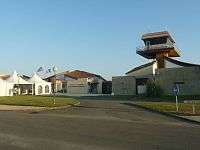
Angoulême – Cognac International Airport
| Angoulême – Cognac International Airport Aéroport international d'Angoulême-Cognac | |||||||||||
|---|---|---|---|---|---|---|---|---|---|---|---|
 | |||||||||||
| Summary | |||||||||||
| Airport type | Public | ||||||||||
| Operator | CCI d'Angoulême | ||||||||||
| Serves | Angoulême, Charente, Poitou-Charentes, France | ||||||||||
| Location | Champniers | ||||||||||
| Elevation AMSL | 133 m / 436 ft | ||||||||||
| Coordinates | 45°43′44″N 000°13′08″E / 45.72889°N 0.21889°ECoordinates: 45°43′44″N 000°13′08″E / 45.72889°N 0.21889°E | ||||||||||
| Website | Aéroport Angoulême-Cognac | ||||||||||
| Map | |||||||||||
 LFBU Airport in Nouvelle-Aquitaine region | |||||||||||
| Runways | |||||||||||
| |||||||||||
Angoulême – Cognac International Airport (French: Aéroport international d'Angoulême - Cognac), also known as Angoulême – Brie – Champniers Airport (French: Aéroport d'Angoulême - Brie - Champniers), (IATA: ANG, ICAO: LFBU) is an airport located 15 kilometres (9.3 mi) northeast of Angoulême,[1] between Brie and Champniers, all communes of the Charente département in the Nouvelle-Aquitaine région of France.
References
- 1 2 LFBU – Angoulême Brie Champniers. AIP from French Service d'information aéronautique, effective 11 October 2018.
- ↑ Airport information for LFBU at World Aero Data. Data current as of October 2006.
External links
- CCI d'Angoulême (in French)
- Aéroport d'Angoulême - Brie Champniers at Union des Aéroports Français (in French)
- Accident history for ANG at Aviation Safety Network
This article is issued from
Wikipedia.
The text is licensed under Creative Commons - Attribution - Sharealike.
Additional terms may apply for the media files.