Angitis
| Angitis | |
|---|---|
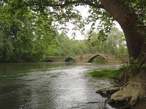 The old bridge of Aggitis River in Alistrati | |
| Native name | Αγγίτης |
| Country | Greece |
| Physical characteristics | |
| River mouth |
Strymonas 40°54′08″N 23°48′38″E / 40.9021°N 23.8105°ECoordinates: 40°54′08″N 23°48′38″E / 40.9021°N 23.8105°E |
| Basin features | |
| Progression | Struma→ Aegean Sea |
The Angitis (Greek: Αγγίτης), also known as Angista and Dramatitsa, is a tributary of the Strymonas in Northern Greece.[1] The river is 75 km (47 mi) long and an important tributary of the Strymonas.
Its source is in the Falakro mountains, in the regional unit of Drama, near the town of Prosotsani. It flows south until Fotolivos, where it turns west and enters the Serres regional unit. It flows into the Strymonas near Tragilos.
The river is the setting for a number of extreme sports, including rafting.[2] The Angitis cave is 21 km (13 mi) long. A short distance from the cave is the gorge of the Angitis, 15 km (9.3 mi) in length with a depth that reaches 100 m (330 ft) down to the river bed.
Notes
- ↑
- Natural Heritage from East to West, Niki Evelpidou, Tomás de Figueiredo, Francesco Mauro, Springer, 2009, ISBN 3-642-01576-X, pp. 51-57.
- D. C. Samsaris, Historical Geography of Eastern Macedonia during the Antiquity (in Greek), Thessaloniki 1976 (Society for Macedonian Studies), p. 19-20. ISBN 960-7265-16-5
- ↑ "Rafting in river Aggitis". Retrieved 18 September 2011.
This article is issued from
Wikipedia.
The text is licensed under Creative Commons - Attribution - Sharealike.
Additional terms may apply for the media files.