Angas Street, Adelaide
| Angas Street South Australia | |
|---|---|
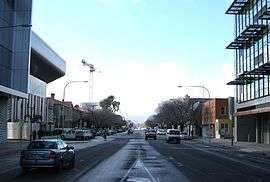 | |
| Angas Street, looking east from King William St | |
| General information | |
| Type | Street |
| Location | Adelaide |
| Length | 1.4 km (0.9 mi) |
| Opened | 1837 |
| Major junctions | |
| Western end | King William Street/Victoria Square |
| Pulteney Street, Frome Street,Hutt Street | |
| Eastern end | East Terrace |
| Location(s) | |
| Suburb(s) | Adelaide |
Angas Street is a main street in the CBD of the centre of Adelaide, South Australia.[1][2] The rear of St Aloysius College faces the street, and various law courts are on the street, including the Dame Roma Mitchell Building. The street is named after George Fife Angas, the first chairman of the South Australian Company.[3]
Angas Street runs from the southern end of Victoria Square to East Terrace, Adelaide. It is one of the intermediate-width streets of the Adelaide grid, and is 1 1⁄2 chains (99 ft; 30 m) wide.
Junction list
| Location | km[4] | mi | Destinations | Notes | |
|---|---|---|---|---|---|
| Adelaide city centre | 0 | 0.0 | Victoria Square, King William Street | Continues as Gouger Street | |
| 0.55 | 0.34 | Pulteney Street | |||
| 0.75 | 0.47 | Frome Street / Regent Street North | |||
| 1.1 | 0.68 | Hutt Street | |||
| 1.4 | 0.87 | East Terrace | |||
| 1.000 mi = 1.609 km; 1.000 km = 0.621 mi | |||||
See also
![]()
References
- ↑ 2003 Adelaide Street Directory, 41st Edition. UBD (A Division of Universal Press Pty Ltd). 2003. ISBN 0-7319-1441-4.
- ↑ Map of the Adelaide CBD, North Adelaide and the Adelaide Parklands.
- ↑ Pastoral Pioneers of South Australia Volume 1 (PDF). The Adelaide Stock and Station Journal. 1925. p. 9. Retrieved 26 September 2014.
- ↑ Google (11 December 2016). "Angas Street, Adelaide" (Map). Google Maps. Google. Retrieved 11 December 2016.
Streets and squares of Adelaide city centre | |||||||||||||
|---|---|---|---|---|---|---|---|---|---|---|---|---|---|
| |||||||||||||
This article is issued from
Wikipedia.
The text is licensed under Creative Commons - Attribution - Sharealike.
Additional terms may apply for the media files.