Anemurium
Anemurium (Ancient Greek Ανεμούριον, Anemourion) is an ancient city whose ruins, now called Eski Anamur or Anemuryum, are close to the modern Turkish city of Anamur. It was in the Roman province of Cilicia, laterIsauria, and was situated near a high promontory (Cape Anamur) that marks the southernmost point of Asia Minor, only 64 km from Cyprus. In medieval times, it was called Stallimur.[1][2]
History
Anemurium was already in existence in the Hellenistic period. In AD 52, it was besieged by native inhabitants of the area, and was under threat from a similar quarter in 382. Coins from its mint survive from the time of Antiochus IV of Commagene (38–72) to Valerian (253–259).[1] In 260, it was captured by the Sasanians, an event that sent Anemurium into decline for many decades,[3] but it continued to be prosperous until the mid-7th century when it was more or less completely abandoned, probably because the Arab occupation of Cyprus made the coast unsafe.[1]
Bishopric
Iacobus, bishop of Anemurium, took part in the Council of Chalcedon in 451. Euphronius was a signatory of the letter by which the bishops of the Roman province of Isauria, to which Anemurium belonged, protested to Byzantine Emperor Leo I the Thracian in 458 about the killing of Proterius of Alexandria. Ioannes was deposed by the Emperor Justin I in 518 for supporting the views of Severus of Antioch. Mamas was at the Trullan Council of 692.[4][5]
No longer a residential bishopric, Anemurium is today listed by the Catholic Church as a titular see.[6]
Remains

The ruins of Anemurium were mentioned by Francis Beaufort, an English naval captain who explored the south coast of Turkey in 1811-12 and who published his discoveries in Karamania. Excavations were directed by Elizabeth Alfoldi, University of Toronto (1965–1970), and subsequently James Russell, University of British Columbia, along with Hector Williams and his wife Caroline.[3]
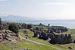
The upper city or acropolis occupies the actual cape, and is described in the Princeton Encyclopedia of Classical Sites as protected on three sides by steep cliffs and on the landward side by a wall with towers and zigzag reentrants. These fortifications and the building inside were constructed in medieval times, in part utilizing Hellenistic elements. The lower town to the north of the citadel extended for at least 1500 m to an area now covered with sand dunes and with a width of 400 m between the eastern seawall and an aqueduct on the west.[1]

The discovered remains include a large theatre, a small covered odeon or bouleuterion, three large public baths and one small one, decorated with mosaic floors (some converted to industrial use in late antiquity), four early Christian churches (some with mosaic floors, mostly geometric, and donors' inscriptions),[7] and an exedra possibly of a civil basilica (law court).[1][3]
Outside, there is an extensive necropolis of some 350 sepulchral monuments dating from the 1st to the early 4th century. Some included several rooms, a second storey, and even an inner courtyard. Some were decorated with mosaics and wall paintings, including one (BI16) representing the four seasons and a dining couple.[1][3]
Nearby Mamure Castle, built by the Armenian Kingdom of Cilicia (Little Armenia) on the foundations of a Roman castle, fell into Turkish hands in 1221.
References
| Wikimedia Commons has media related to Anemurium. |
- 1 2 3 4 5 6 "The Princeton Encyclopedia of Classical Sites, AACHEN, see AQUAE GRANNI, ANEMURIUM (Eski Anamur) later ISAURIA Rough Cilicia, Turkey". www.perseus.tufts.edu. Retrieved 2017-12-09.
- ↑ "CATHOLIC ENCYCLOPEDIA: Anemurium". www.newadvent.org. Retrieved 2017-12-09.
- 1 2 3 4 University of British Columbia Archaeology Magazine
- ↑ Michel Lequien, Oriens christianus in quatuor Patriarchatus digestus, Paris 1740, Vol. II, coll. 1015-1018
- ↑ Siméon Pétridès, v. Anemurium, in Dictionnaire d'Histoire et de Géographie ecclésiastiques, vol. II, Paris 1914, coll. 1828-1829
- ↑ Annuario Pontificio 2013 (Libreria Editrice Vaticana 2013 ISBN 978-88-209-9070-1), p. 833
- ↑ Edwards, Robert W., "Anamur" (2016). The Eerdmans Encyclopedia of Early Christian Art and Archaeology, ed., Paul Corby Finney. Grand Rapids, Michigan: William B. Eerdmans Publishing. pp. 55–56. ISBN 978-0-8028-9016-0.
Coordinates: 36°01′27.37″N 32°48′09.36″E / 36.0242694°N 32.8026000°E