Andalusia, Alabama
| Andalusia, Alabama | |
|---|---|
| City | |
| Motto(s): "A proud heritage. A progressive future." | |
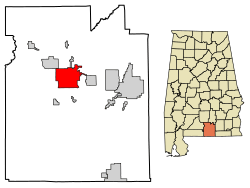 Location of Andalusia in Covington County, Alabama. | |
| Coordinates: 31°18′N 86°29′W / 31.300°N 86.483°W | |
| Country | United States |
| State | Alabama |
| County | Covington |
| Settled | 1841 |
| Incorporated | 1884 |
| Government | |
| • Type | Mayor/City Council |
| • Mayor | Earl Johnson |
| Area[1] | |
| • Total | 19.81 sq mi (51.32 km2) |
| • Land | 19.66 sq mi (50.91 km2) |
| • Water | 0.16 sq mi (0.41 km2) |
| Elevation | 348 ft (106 m) |
| Population (2010) | |
| • Total | 9,015 |
| • Estimate (2017)[2] | 8,787 |
| • Density | 447.02/sq mi (172.59/km2) |
| Time zone | UTC-6 (CST) |
| • Summer (DST) | UTC-5 (CDT) |
| ZIP code | 36420 |
| Area code(s) | 334 |
| FIPS code | 01-01708 |
| GNIS feature ID | 0133361 |
| Website |
www |
Andalusia is a city in and the county seat of Covington County, Alabama, United States. At the 2010 census the population was 9,015.[3]
History
Andalusia was first settled in 1841 after flooding of the Conecuh River and the surrounding lowlands forced citizens to move to higher ground. The county seat was moved from Montezuma to Andalusia in 1844. The new town was originally called "New Site" but was known as Andalusia by the time a post office was established in 1846.[4]
Andalusia, likely got its name from Spanish explorers or settlers since the land where the town is located was part of Spanish Florida until Pinckney's Treaty in 1795. Prior to this treaty, the Spanish Empire claimed all land up to 32.22 degrees north, which would include present day Andalusia which is at 31.31 degrees north. Andalusia shares the name of Andalusia, a large southern autonomous community of Spain.
Andalusia was incorporated as a town in 1884.[5]
In 1899, two railroad lines arrived in Andalusia, the Central of Georgia and the L & N Railroad, and the town began to grow.[6]
The Avant House is one of seven sites in Andalusia listed on the National Register of Historic Places.
Geography
Andalusia is located slightly northwest of the center of Covington County at 31°18′N 86°29′W / 31.300°N 86.483°W (31.309, -86.479).[7] According to the U.S. Census Bureau, the city has a total area of 19.8 square miles (51.3 km2), of which 19.7 square miles (50.9 km2) is land and 0.15 square miles (0.4 km2), or 0.79%, is water.[3]
Andalusia is served by the South Alabama Regional Airport, formerly known as the Andalusia-Opp Airport, located approximately 5 miles (8 km) east of the central business district.
Climate
The climate in this area is characterized by hot, humid summers and generally mild to cool winters. According to the Köppen Climate Classification system, Andalusia has a humid subtropical climate, abbreviated "Cfa" on climate maps.[8]
| Climate data for Andalusia, Alabama (1981–2010, extremes 1912–present) | |||||||||||||
|---|---|---|---|---|---|---|---|---|---|---|---|---|---|
| Month | Jan | Feb | Mar | Apr | May | Jun | Jul | Aug | Sep | Oct | Nov | Dec | Year |
| Record high °F (°C) | 84 (29) |
87 (31) |
89 (32) |
97 (36) |
100 (38) |
105 (41) |
105 (41) |
105 (41) |
101 (38) |
99 (37) |
88 (31) |
84 (29) |
105 (41) |
| Average high °F (°C) | 60.9 (16.1) |
65.2 (18.4) |
72.2 (22.3) |
78.3 (25.7) |
85.0 (29.4) |
90.0 (32.2) |
91.7 (33.2) |
91.1 (32.8) |
87.6 (30.9) |
79.9 (26.6) |
71.6 (22) |
62.9 (17.2) |
78.1 (25.6) |
| Daily mean °F (°C) | 46.6 (8.1) |
50.2 (10.1) |
56.5 (13.6) |
62.5 (16.9) |
70.5 (21.4) |
77.3 (25.2) |
79.6 (26.4) |
79.3 (26.3) |
74.7 (23.7) |
64.8 (18.2) |
56.0 (13.3) |
48.8 (9.3) |
64.0 (17.8) |
| Average low °F (°C) | 32.2 (0.1) |
35.2 (1.8) |
40.9 (4.9) |
46.7 (8.2) |
56.0 (13.3) |
64.5 (18.1) |
67.5 (19.7) |
67.6 (19.8) |
61.7 (16.5) |
49.7 (9.8) |
40.3 (4.6) |
34.7 (1.5) |
49.8 (9.9) |
| Record low °F (°C) | 5 (−15) |
10 (−12) |
16 (−9) |
27 (−3) |
34 (1) |
44 (7) |
50 (10) |
54 (12) |
34 (1) |
28 (−2) |
16 (−9) |
2 (−17) |
2 (−17) |
| Average precipitation inches (mm) | 5.18 (131.6) |
5.30 (134.6) |
6.35 (161.3) |
4.17 (105.9) |
3.89 (98.8) |
5.30 (134.6) |
6.16 (156.5) |
5.65 (143.5) |
4.62 (117.3) |
3.71 (94.2) |
4.73 (120.1) |
4.91 (124.7) |
59.97 (1,523.2) |
| Average precipitation days (≥ 0.01 in) | 8.7 | 7.9 | 7.8 | 6.5 | 6.7 | 10.0 | 11.2 | 9.9 | 7.3 | 5.3 | 6.9 | 7.7 | 95.9 |
| Source: NOAA[9][10] | |||||||||||||
Demographics
| Historical population | |||
|---|---|---|---|
| Census | Pop. | %± | |
| 1880 | 596 | — | |
| 1890 | 270 | −54.7% | |
| 1900 | 551 | 104.1% | |
| 1910 | 2,480 | 350.1% | |
| 1920 | 4,023 | 62.2% | |
| 1930 | 5,154 | 28.1% | |
| 1940 | 6,886 | 33.6% | |
| 1950 | 9,162 | 33.1% | |
| 1960 | 10,263 | 12.0% | |
| 1970 | 10,092 | −1.7% | |
| 1980 | 10,415 | 3.2% | |
| 1990 | 9,269 | −11.0% | |
| 2000 | 8,794 | −5.1% | |
| 2010 | 9,015 | 2.5% | |
| Est. 2017 | 8,787 | [2] | −2.5% |
| U.S. Decennial Census[11] 2013 Estimate[12] | |||
2010 census
As of the census[13] of 2010, there were 9,015 people, 3,694 households, and 2,359 families residing in the city. The racial makeup of the city was 70.5% White, 25.9% Black or African American, 0.4% Native American, 1.0% Asian, 0.0% Pacific Islander, 0.4% from other races, and 1.7% from two or more races. 1.9% of the population were Hispanic or Latino of any race.
There were 3,694 households out of which 26.7% had children under the age of 18 living with them, 40.9% were married couples living together, 18.3% had a female householder with no husband present, and 36.1% were non-families. 31.3% of all households were made up of individuals and 14.9% had someone living alone who was 65 years of age or older. The average household size was 2.35 and the average family size was 2.93.
In the city, the population was spread out with 23.4% under the age of 18, 9.2% from 18 to 24, 23.6% from 25 to 44, 25.1% from 45 to 64, and 18.7% who were 65 years of age or older. The median age was 39.7 years. For every 100 females, there were 86.6 males. For every 100 females age 18 and over, there were 91.2 males.
The median income for a household in the city was $28,049, and the median income for a family was $37,059. Males had a median income of $27,228 versus $25,855 for females. The per capita income for the city was $19,544. About 20.2% of families and 22.8% of the population were below the poverty line, including 35.4% of those under age 18 and 14.5% of those age 65 or over.
2000 Census data
As of the census[14] of 2000, there were 8,794 people, 3,707 households, and 2,376 families residing in the city.[15] The population density was 465.9 inhabitants per square mile (179.9/km2). There were 4,279 housing units at an average density of 226.7 per square mile (87.5/km2).[16] The racial makeup of the city was 73.93% White, 24.47% Black or African American, 0.36% Native American, 0.27% Asian, 0.02% Pacific Islander, 0.18% from other races, and 0.76% from two or more races. 0.78% of the population were Hispanic or Latino of any race.[15]
There were 3,707 households out of which 27.9% had children under the age of 18 living with them, 46.5% were married couples living together, 14.4% had a female householder with no husband present, and 35.9% were non-families. 33.3% of all households were made up of individuals and 17.1% had someone living alone who was 65 years of age or older. The average household size was 2.29 and the average family size was 2.91.[15]
In the city, the population was spread out with 23.2% under the age of 18, 8.4% from 18 to 24, 25.0% from 25 to 44, 22.6% from 45 to 64, and 20.8% who were 65 years of age or older. The median age was 40 years. For every 100 females, there were 84.4 males. For every 100 females age 18 and over, there were 79.5 males.[15]
The median income for a household in the city was $26,856, and the median income for a family was $37,091. Males had a median income of $29,406 versus $20,410 for females. The per capita income for the city was $17,292. About 15.7% of families and 20.6% of the population were below the poverty line, including 28.6% of those under age 18 and 18.9% of those age 65 or over.[15]
Media
Education
Primary and secondary public education is provided by Andalusia City Schools, which consists of Andalusia Elementary School, Andalusia Middle School, and Andalusia High School. Students can continue their studies at Lurleen B. Wallace Community College.
Transportation
Intercity bus service is provided by Greyhound Lines.[17]
Sites on the National Register of Historic Places
Notable people
- William Harold Albritton III, U.S. district court judge
- Dempsey J. Barron, President of the Florida Senate from 1975–1976
- Erica Boyer, pornographic actress; daughter of Alabama Assistant Attorney General Joseph 'Joe Breck' Breckenridge Gantt[18][19]
- Charles Brooks, editorial cartoonist
- James U. Cross, retired U.S. Air Force brigadier general and chief Air Force One pilot under president Lyndon B. Johnson
- Cecil O. De Loach, Jr., California grape-grower and winemaker
- Quinton Dial, defensive tackle for the Alabama Crimson Tide
- Irwin Gunsalus, biochemist; assistant secretary general at the United Nations
- Seth Hammett, Speaker of the Alabama House of Representatives
- Robert Horry, basketball player, one of only two players to have won the National Basketball Association championship with three different teams
- Nico Johnson, one of two members of the University of Alabama's football team to start in their National Championship victories in 2009, 2011 and 2012
- Alexa Jones, Miss Alabama 2005 and Miss America 2006 (second runner-up)[20]
- T. D. Little, member of Alabama Senate and House of Representatives
- Lamar Morris, country music singer
- Frank J. Tipler, mathematical physicist and cosmologist; author of books and papers about a mechanism for the resurrection of the dead
References
- ↑ "2017 U.S. Gazetteer Files". United States Census Bureau. Retrieved Jul 7, 2018.
- 1 2 "Population and Housing Unit Estimates". Retrieved March 24, 2018.
- 1 2 "Geographic Identifiers: 2010 Demographic Profile Data (G001): Andalusia city, Alabama". U.S. Census Bureau, American Factfinder. Retrieved June 9, 2014.
- ↑ Hoskins Morton, Patricia (December 10, 2009). "Covington County". Encyclopedia of Alabama. Retrieved 27 January 2010.
- ↑ Owen, Thomas McAdory; Marie Bankhead Owen (1921). History of Alabama and dictionary of Alabama biography, Volume 1. The S. J. Clarke Publishing Company. p. 716.
- ↑ "Community - History of Andalusia". City of Andalusia official site. Retrieved 2014-12-10.
- ↑ "US Gazetteer files: 2010, 2000, and 1990". United States Census Bureau. 2011-02-12. Retrieved 2011-04-23.
- ↑ Climate Summary for Andalusia, Alabama
- ↑ "NowData - NOAA Online Weather Data". National Oceanic and Atmospheric Administration. Retrieved March 18, 2016.
- ↑ "Station Name: AL Andalusia 3 W". National Oceanic and Atmospheric Administration. Retrieved March 18, 2016.
- ↑ "U.S. Decennial Census". Census.gov. Archived from the original on May 12, 2015. Retrieved June 6, 2013.
- ↑ "Annual Estimates of the Resident Population: April 1, 2010 to July 1, 2013". Archived from the original on May 22, 2014. Retrieved June 3, 2014.
- ↑ "American FactFinder". United States Census Bureau. Archived from the original on 2013-09-11. Retrieved 2015-07-20.
- ↑ "American FactFinder". United States Census Bureau. Archived from the original on 2013-09-11. Retrieved 2008-01-31.
- 1 2 3 4 5 "Fact Sheet- Andalusia city, Alabama". American Fast Facts. United States Census Bureau. Retrieved 27 January 2010.
- ↑ "Geographic Comparison Table- Alabama". American Fast Facts. United States Census Bureau.
- ↑ Andalusia, AL Greyhound Station
- ↑ "Amanda Margaret "Mandy" Jensen (1956–2009)". The News Harald.
- ↑ Stanton, Mary (1998). From Selma to Sorrow: The Life and Death of Viola Liuzzo. University of Georgia Press.
- ↑ "Alexa Jones: Miss Alabama". Country Music Television.
External links
- City of Andalusia official website
- Andalusia City Schools
- Covington County Schools
- Andalusia Area Chamber of Commerce
- Andalusia Star-News
Coordinates: 31°18′32″N 86°28′44″W / 31.309°N 86.479°W
Municipalities and communities of Covington County, Alabama, United States | ||
|---|---|---|
| Cities | 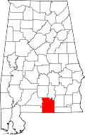 | |
| Towns | ||
| Unincorporated community | ||