Sangkhom District
| Sangkhom สังคม | |
|---|---|
| Amphoe | |
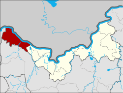 Amphoe location in Nong Khai Province | |
| Coordinates: 18°3′51″N 102°16′24″E / 18.06417°N 102.27333°ECoordinates: 18°3′51″N 102°16′24″E / 18.06417°N 102.27333°E | |
| Country | Thailand |
| Province | Nong Khai |
| Seat | Kaeng Kai |
| Area | |
| • Total | 449.7 km2 (173.6 sq mi) |
| Population (2005) | |
| • Total | 22,998 |
| • Density | 51.1/km2 (132/sq mi) |
| Time zone | UTC+7 (ICT) |
| Postal code | 43160 |
| Geocode | 4308 |
Sangkhom (Thai: สังคม, pronounced [sǎŋ.kʰōm]) is the westernmost district (amphoe) of Nong Khai Province, northeastern Thailand.
Geography
Neighboring districts are (from the east clockwise) Si Chiang Mai and Pho Tak of Nong Khai Province, Na Yung of Udon Thani Province and Pak Chom of Loei Province. To the north across the Mekong River is the Laotian province Vientiane Prefecture.
History
Originally the area was a tambon of Tha Bo District, which became part of the newly established Si Chiang Mai District on 4 August 1958. It was established as a minor district (king amphoe) on 1 March 1966,[1] and upgraded to a full district on 16 November 1971.[2] From 14 November 1975 to 14 November 1978 the district was under military administration as part of a military operation.
Symbols
The district slogan is "Naga Fireball Festival; famous dried bananas; golden beaches".
Administration
The district is divided into five sub-districts (tambon), which are further subdivided into 36 villages (muban). Sangkhom is a township (thesaban tambon) which covers parts of tambon Sangkhom and Kaeng Kai. There are a further five tambon administrative organizations (TAO).
| No. | Name | Thai name | Villages | Pop. | |
|---|---|---|---|---|---|
| 1. | Kaeng Kai | แก้งไก่ | 6 | 4,304 | |
| 2. | Pha Tang | ผาตั้ง | 7 | 5,724 | |
| 3. | Ban Muang | บ้านม่วง | 7 | 3,030 | |
| 4. | Na Ngio | นางิ้ว | 9 | 6,094 | |
| 5. | Sangkhom | สังคม | 7 | 3,846 |
References
- ↑ ประกาศกระทรวงมหาดไทย เรื่อง แบ่งท้องที่ตั้งเป็นกิ่งอำเภอ (กิ่งอำเภอสังคม อำเภอศรีเชียงใหม่ จังหวัดหนองคาย) (PDF). Royal Gazette (in Thai). 83 (19 ง): 997. March 1, 1966.
- ↑ พระราชกฤษฎีกาตั้งอำเภอปลาปาก อำเภอเชียงกลาง อำเภอปากชม อำเภอบ้านม่วง อำเภอพังโคน อำเภอดอนสัก อำเภอพนม อำเภอเวียงสระ อำเภอสังคม และอำเภอหัวตะพาน พ.ศ. ๒๕๑๔ (PDF). Royal Gazette (in Thai). 88 (123 ก): 745–748. November 16, 1971.