Sadao District
| Sadao สะเดา | |
|---|---|
| District | |
.jpg) Temple of the Thousand Buddhas, Wat Tham Khao Rup Chang | |
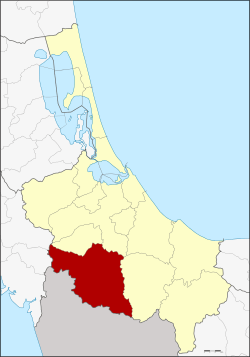 District location in Songkhla Province | |
| Coordinates: 6°38′19″N 100°25′26″E / 6.63861°N 100.42389°ECoordinates: 6°38′19″N 100°25′26″E / 6.63861°N 100.42389°E | |
| Country | Thailand |
| Province | Songkhla |
| Seat | Sadao |
| District established | 1909 |
| Area | |
| • Total | 1,029.273 km2 (397.405 sq mi) |
| Population (2009) | |
| • Total | 120,306 |
| • Density | 116.5/km2 (302/sq mi) |
| Time zone | UTC+7 (ICT) |
| Postal code | 90120[1] |
| Geocode | 9010 |
Sadao (Thai: สะเดา, pronounced [sā.dāw]) is district (amphoe) on the border of Malaysia in Songkhla Province, southern Thailand.
Sadao is a small town better known as Danok (Thai: ด่านนอก, RTGS: dan nok) on the crossing border with Malaysia on Phetkasem Road at tambon Samnak Kham.
History
Historically Sadao is part of Kedah in the district of Changlun, which means 'an elephant falls' in Thai. The district was formerly part of Changlun, and was then under the overlordship of Malay Sultanate of Kedah (known as Syburi in Thai). Sadao is called "Sendawa" in Malay.
When the Britain and Siam (Thailand) signed the Anglo-Siamese Treaty of 1909, deciding what belonged to whom, Changlun was divided into two parts. The main border town of Changlun became the district of Kubang Pasu, now in Kedah of Malaysia. The rest remained Thai. Tambon Sadao, together with the former minor district (king amphoe) Prik, forms modern Sadao.[2]
Etymology
The name "sadao" is the Thai word for Neem Tree.
Geography
Neighboring districts are (from the west clockwise) Khuan Don and Khuan Kalong of Satun Province, Khlong Hoi Khong, Hat Yai, Chana, and Na Thawi of Songkhla Province. To the southwest is the state of Kedah and Perlis in Malaysia.
Transportation
The district marks the end of Phetkasem Road, the longest road in Thailand, which runs from Bangkok to the border at Danok (Thailand)–Bukit Kayu Hitam (Malaysia).
Two main border crossings with Malaysia are located in the district. The main crossing is at Ban Dan Nok (บ้านด่านนอก), with Bukit Kayu Hitam on the Malaysian side. The other quieter crossing is at Padangbesa, with the Malaysian town of Padang Besar in Perlis on the Malaysian side. The main railway crossing between Malaysia and Thailand is also at Padang Besar.
Administration
The district is divided into nine sub-districts (tambon), which are further subdivided into 67 villages (muban). The town (thesaban mueang) of Sadao covers tambon Sadao. Padangbesa is another town which covers parts of the tambon Padangbesa. There are three sub-district municipalities (thesaban tambon): Prik and Phang La each covering parts of the same-named tambon, and Samnak Kham the full tambon Samnak Kham. There are a further seven tambon administrative organizations (TAO) responsible for the non-municipal areas.
| No. | Name | Thai | Villages | Pop.[3] |
|---|---|---|---|---|
| 1. | Sadao | สะเดา | - | 19,284 |
| 2. | Prik | ปริก | 11 | 20,808 |
| 3. | Phang La | พังลา | 7 | 12,570 |
| 4. | Samnak Taeo | สำนักแต้ว | 10 | 13,180 |
| 5. | Thung Mo | ทุ่งหมอ | 7 | 7,070 |
| 6. | Tha Pho | ท่าโพธิ์ | 8 | 6,416 |
| 7. | Padangbesa (Padang Besar) | ปาดังเบซาร์ | 12 | 24,066 |
| 8. | Samnak Kham | สำนักขาม | 7 | 11,864 |
| 9. | Khao Mi Kiat | เขามีเกียรติ | 5 | 5,048 |
Gallery
 The Sadao checkpoint at Danok.
.jpg) Pa-dang Besa, Sadao District
Pa-dang Besa, Sadao District.jpg) Railway line in Pa-dang Besa, Sadao District
Railway line in Pa-dang Besa, Sadao District Pa-dang Besa, Sadao District
.jpg) Wat Tham Khao Rup Chang, tambon Pa-dang Besa
Wat Tham Khao Rup Chang, tambon Pa-dang Besa.jpg) Wat Phang La, tambon Phang La
Wat Phang La, tambon Phang La.jpg) Danok
Danok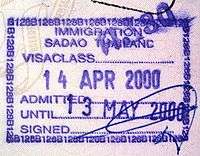 Entry stamp from the Sadao border crossing at Danok.
References
- ↑ Sub-districts Phang La, Tha Pho and Khao Mi Kiat have postal code 90170, sub-districts Thung Mo and Padang Besa have 90240, village 1, 2, 5, 6, 7 of sub-district Samnak Kham have 90320
- ↑ ประกาศกระทรวงมหาดไทย ประกาศตั้งอำเภอสะเดาและอำเภอตากใบ (PDF). Royal Gazette (in Thai). 26 (0 ง): 1107–1108. 1909-08-22.
- ↑ "Population statistics 2009". Department of Provincial Administration.
External links
- amphoe.com (Thai)