Mae Chaem District
| Mae Chaem แม่แจ่ม | |
|---|---|
| District | |
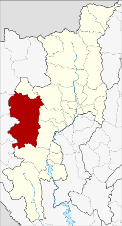 District location in Chiang Mai Province | |
| Coordinates: 18°29′56″N 98°21′43″E / 18.49889°N 98.36194°ECoordinates: 18°29′56″N 98°21′43″E / 18.49889°N 98.36194°E | |
| Country | Thailand |
| Province | Chiang Mai |
| Seat | Chang Khoeng |
| District established | 1908 |
| Area | |
| • Total | 2,713.57 km2 (1,047.72 sq mi) |
| Population (2008) | |
| • Total | 57,214 |
| • Density | 21.1/km2 (55/sq mi) |
| Time zone | UTC+7 (ICT) |
| Postal code | 50270 |
| Geocode | 5003 |
Mae Chaem (Thai: แม่แจ่ม, pronounced [mɛ̂ː t͡ɕɛ̀m]) is a district (amphoe) of Chiang Mai Province in northern Thailand.
History
Mueang Chaem was created in 1908,[1] consisting of the tambons Mae Thap, Tha Pha, Chang Khoeng, and Mae Suek split off from Chom Thong. In 1917 it was renamed Chang Khoeng, as the district office was in that tambon.[2] In 1938 it was reduced to a minor district (king amphoe) and was subordinate to Chom Thong District.[3] In 1939 it was renamed Mae Chaem.[4] In 1956 it was upgraded to a full district.[5]
In 2009 the northern part of the district was split off to form the new district, Galyani Vadhana.[6]
Geography
Neighboring districts are (from the north clockwise) Galyani Vadhana, Samoeng, Mae Wang, Chom Thong and Hot of Chiang Mai Province, and Mae Sariang, Mae La Noi, Khun Yuam, Mueang Mae Hong Son and Pai of Mae Hong Son Province.
Thailand's highest mountain, 2,565 meters (8,415 feet) high Doi Inthanon, in the Thanon Thong Chai Range, is in Mae Chaem District.
Administration
The district is divided into seven sub-districts (tambon), which are further subdivided into 85 villages (muban). Mae Chaem also has sub-district municipality (thesaban tambon) status and covers parts of tambon Chang Khoeng. There are a further seven tambon administrative organizations (TAO).
| No. | Name | Thai | Villages | Pop.[7] |
|---|---|---|---|---|
| 1. | Chang Khoeng | ช่างเคิ่ง | 19 | 11,206 |
| 2. | Tha Pha | ท่าผา | 14 | 4,952 |
| 3. | Ban Thap | บ้านทับ | 13 | 6,234 |
| 4. | Mae Suek | แม่ศึก | 17 | 11,577 |
| 5. | Mae Na Chon | แม่นาจร | 19 | 10,184 |
| 7. | Pang Hin Fon | ปางหินฝน | 14 | 6,856 |
| 8. | Kong Khaek | กองแขก | 12 | 6,205 |
Missing numbers belong to the sub-districts which became Galyani Vadhana District in 2009.
Gallery
References
- ↑ แจ้งความกระทรวงมหาดไทย (PDF). Royal Gazette (in Thai). 25 (15): 447–448. July 4, 1908.
- ↑ ประกาศกระทรวงมหาดไทย เรื่อง เปลี่ยนชื่ออำเภอ (PDF). Royal Gazette (in Thai). 34 (0 ก): 40–68. April 29, 1917.
- ↑ ประกาศสำนักนายกรัฐมนตรี เรื่อง ยุบอำเภอลงเป็นกิ่งอำเภอ (PDF). Royal Gazette (in Thai). 55 (0 ง): 2067. September 12, 1938.
- ↑ พระราชกฤษฎีกาเปลี่ยนนามอำเภอ กิ่งอำเภอ และตำบลบางแห่ง พุทธศักราช ๒๔๘๒ (PDF). Royal Gazette (in Thai). 56 (0 ก): 354–364. April 17, 1939.
- ↑ พระราชกฤษฎีกาจัดตั้งอำเภอนาทวี อำเภอสะบ้าย้อย อำเภอคำชะอี อำเภอย่านตาขาว อำเภอวัดโบสถ์ อำเภอหนองบัว อำเภอวัฒนานคร อำเภอแสวงหา อำเภอท่าชนะ อำเภอพระพุทธบาท อำเภอโนนสัง อำเภอบำเหน็จณรงค์ อำเภอคอนสวรรค์ อำเภอบ้านโฮ่ง อำเภอคีรีมาศ อำเภอชนแดน อำเภอแม่แจ่ม อำเภอไทรน้อย และอำเภอบ้านแพง พ.ศ. ๒๔๙๙ (PDF). Royal Gazette (in Thai). 73 (46 ก): 657–661. June 5, 1956.
- ↑ พระราชกฤษฎีกาตั้งอำเภอกัลยาณิวัฒนา จังหวัดเชียงใหม่ พ.ศ. ๒๕๕๒ (PDF). Royal Gazette (in Thai). 126 (97 ก): 7–9. 2009-12-25.
- ↑ "Population statistics 2008". Department of Provincial Administration. Archived from the original on 2012-08-19.
External links
| Wikimedia Commons has media related to Mae Chaem District. |