Hat Samran District
| Hat Samran หาดสำราญ | |
|---|---|
| District | |
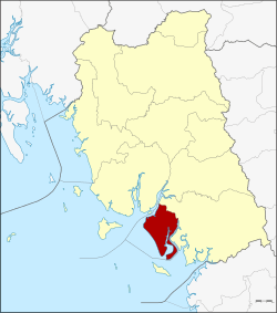 District location in Trang Province | |
| Coordinates: 7°14′24″N 99°34′36″E / 7.24000°N 99.57667°ECoordinates: 7°14′24″N 99°34′36″E / 7.24000°N 99.57667°E | |
| Country | Thailand |
| Province | Trang |
| Seat | Hat Samran |
| Area | |
| • Total | 224.0 km2 (86.5 sq mi) |
| Population (2005) | |
| • Total | 15,550 |
| • Density | 69.4/km2 (180/sq mi) |
| Time zone | UTC+7 (ICT) |
| Postal code | 92120 |
| Geocode | 9210 |
Hat Samran (Thai: หาดสำราญ, pronounced [hàːt sǎm.rāːn]) is a district (amphoe) in the southern part of Trang Province, Thailand.
History
The minor district (king amphoe) Hat Samran was established on 30 April 1994 by splitting it from Palian District.[1]
In 2007 all 81 minor districts were upgraded to full districts.[2] With publication in the Royal Gazette on 24 August 2007 the upgrade became official.[3]
Administration
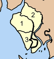
The district is divided into three sub-districts (tambons), which are further subdivided into 21 villages (mubans). There are no municipal (thesaban) areas, and three tambon administrative organizations (TAO).
|
 |
References
- ↑ ประกาศกระทรวงมหาดไทย เรื่อง แบ่งเขตท้องที่อำเภอปะเหลียน จังหวัดตรัง ตั้งเป็นกิ่งอำเภอหาดสำราญ (PDF). Royal Gazette (in Thai). 111 (42 ง): 29. May 26, 1994.
- ↑ แถลงผลการประชุม ครม. ประจำวันที่ 15 พ.ค. 2550 (in Thai). Manager Online.
- ↑ พระราชกฤษฎีกาตั้งอำเภอฆ้องชัย...และอำเภอเหล่าเสือโก้ก พ.ศ. ๒๕๕๐ (PDF). Royal Gazette (in Thai). 124 (46 ก): 14–21. August 24, 2007.
External links
This article is issued from
Wikipedia.
The text is licensed under Creative Commons - Attribution - Sharealike.
Additional terms may apply for the media files.