Amlan, Negros Oriental
| Amlan | |
|---|---|
| Municipality | |
| Municipality of Amlan | |
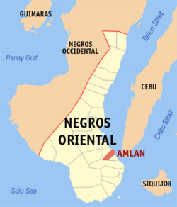 Map of Negros Oriental with Amlan highlighted | |
.svg.png) Amlan Location within the Philippines | |
| Coordinates: 9°27′N 123°14′E / 9.45°N 123.23°ECoordinates: 9°27′N 123°14′E / 9.45°N 123.23°E | |
| Country |
|
| Region | Central Visayas (Region VII) |
| Province | Negros Oriental |
| District | 2nd district of Negros Oriental |
| Barangays | 8 (see Barangays) |
| Government [1] | |
| • Type | Sangguniang Bayan |
| • Mayor | Gino De La Cruz |
| • Vice Mayor | Bentham P. De La Cruz |
| • Electorate | 15,167 voters (2016) |
| Area [2] | |
| • Total | 111.85 km2 (43.19 sq mi) |
| Population (2015 census)[3] | |
| • Total | 23,624 |
| • Density | 210/km2 (550/sq mi) |
| Time zone | UTC+8 (PST) |
| ZIP code | 6203 |
| PSGC | 074601000 |
| IDD : area code | +63 (0)35 |
| Climate type | Tropical climate |
| Income class | 4th municipal income class |
| Revenue (₱) | 80,834,703.92 (2016) |
| Native languages |
Cebuano Tagalog |
| Website |
www |
Amlan, officially the Municipality of Amlan, is a 4th class municipality in the province of Negros Oriental, Philippines. According to the 2015 census, it has a population of 23,624 people.[3]
Amlan was formerly known as New Ayuquitan.[4]
History
Nineteenth-century chronicler Licinio Ruiz mentions Alman, a settlement said to have been named after a superior kind of guava. The town was made a parish independent of Tanjay in 1848, was renamed New Ayuquitan in 1912, became Amlan after WW II.
Its Church of St. Andrew the Apostle, completed in 1853 (and said to have taken 50 years to build), is the centerpiece of the town’s tourism while providing photo opportunists with a colonial period backdrop. The ruins of watch towers against the Moro depredations of old can still be seen in Buswang and near the mouth of the Amlan River; and two others near the school building of Ayuquitan and barrio Calo.
Tourism
Amlan is home to many natural and man-made attractions, listed below:
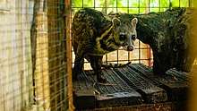
Dreamland Nature and Adventure Park (DNAP) - a ten-minute ride away from the highway, DNAP is divided into two parks: the Animal Kingdom that showcases a collection of wildlife and other endangered species and the Adventure Park for those wanting some adrenaline rush. Activities in the Adventure Park include aerial walk, river tubing, and soon to be added; avatar zip line, zip line and giant swing.
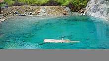
Tandayag Marine Sanctuary - touted as one of Tanon Strait's top sanctuaries, the sanctuary has not seen yet an overcrowding of scuba divers. The fisherfolk managing the area is keen in sustaining the carrying capacity of the marine reserve.
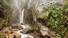
Amlan Pasalan - the most majestic of the many falls found in Amlan, Pasalan is located in Silab Highlands. It can be accessed via all forms of vehicle but for the moment, anyone wnating to see the falls, must first secure approval from the local government for safety reasons.
Asupri sa Maiti - a sulfur lagoon up in Jantianon Highlands, Asupri has seen an increase of tourists after photos and videos the attraction were posted in social media.
Naparil and Cantalina Falls - The most accessible falls in Amlan, Naparil is a short 20-minute walk from the main road in Silab.
Lantawan Amlan - the town's highest peak at 1,101 meters above sea level.
Kang Atid - A good place to start river trekking and explore the environs along the banks of the Amlan River.
Barangays
Amlan is politically subdivided into 8 barangays:
- Bio-os
- Jantianon
- Jugno
- Mag-abo
- Poblacion
- Silab
- Tambojangin
- Tandayag
Demographics
| Population census of Amlan | ||
|---|---|---|
| Year | Pop. | ±% p.a. |
| 1903 | 10,373 | — |
| 1918 | 12,525 | +1.26% |
| 1939 | 14,904 | +0.83% |
| 1948 | 13,342 | −1.22% |
| 1960 | 9,399 | −2.88% |
| 1970 | 11,547 | +2.08% |
| 1975 | 12,457 | +1.53% |
| 1980 | 13,638 | +1.83% |
| 1990 | 16,145 | +1.70% |
| 1995 | 16,573 | +0.49% |
| 2000 | 19,227 | +3.24% |
| 2007 | 22,173 | +1.99% |
| 2010 | 22,206 | +0.05% |
| 2015 | 23,624 | +1.19% |
| Source: Philippine Statistics Authority[3] [6] [7] [8] | ||
Education
Public High Schools[9]
| School Name | Location |
|---|---|
| Amlan National High School | Rizal Street, Poblacion |
| Amlan National High School -Jugno Campus | Jugno |
| Jantianon National High School | Jantianon |
| Silab Comm. High School | Annex, Silab |
Public Elementary Schools[9]
- Amlan CES
- Aurelio Ibero Memorial Elementary School (Jugno Elementary School)
- Bio-os Elementary School
- Cañete Elementary School
- Cantalina Elementary School
- Jantianon Elementary School
- Martin Benjamin Memorial Elementary School (Tambojangin Elementary School )
- Panusuan Elementary School
- Silab Elementary School
- Tandayag Elementary School
References
- ↑ "Municipality". Quezon City, Philippines: Department of the Interior and Local Government. Retrieved 31 May 2013.
- ↑ "Province:". PSGC Interactive. Quezon City, Philippines: Philippine Statistics Authority. Retrieved 12 November 2016.
- 1 2 3 Census of Population (2015). "Region VII (Central Visayas)". Total Population by Province, City, Municipality and Barangay. PSA. Retrieved 20 June 2016.
- ↑ "An act to change the name of the municipality of New Ayuquitan, province of Negros Oriental, to "Amlan" and the name of barrio Old Ayuquitan to "Ayuquitan"". LawPH.com. Retrieved 2011-04-09.
- ↑ www.tourismamlan.com
- ↑ Census of Population and Housing (2010). "Region VII (Central Visayas)". Total Population by Province, City, Municipality and Barangay. NSO. Retrieved 29 June 2016.
- ↑ Censuses of Population (1903–2007). "Region VII (Central Visayas)". Table 1. Population Enumerated in Various Censuses by Province/Highly Urbanized City: 1903 to 2007. NSO.
- ↑ "Province of". Municipality Population Data. Local Water Utilities Administration Research Division. Retrieved 17 December 2016.
- 1 2 "dumaguete.com". Retrieved 2014-10-30.
External links
- Philippine Standard Geographic Code
- Philippine Census Information
- Local Governance Performance Management System
Places adjacent to Amlan, Negros Oriental | |
|---|---|