Alpuech
| Alpuech | |
|---|---|
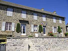 The town hall in Alpuech | |
 Alpuech Location within Occitanie region  Alpuech | |
| Coordinates: 44°45′47″N 2°50′57″E / 44.7631°N 2.8492°ECoordinates: 44°45′47″N 2°50′57″E / 44.7631°N 2.8492°E | |
| Country | France |
| Region | Occitanie |
| Department | Aveyron |
| Arrondissement | Rodez |
| Canton | Aubrac et Carladez |
| Intercommunality | Argence |
| Government | |
| • Mayor (-) | - |
| Area1 | 14.88 km2 (5.75 sq mi) |
| Population (2013)2 | 64 |
| • Density | 4.3/km2 (11/sq mi) |
| Time zone | UTC+1 (CET) |
| • Summer (DST) | UTC+2 (CEST) |
| INSEE/Postal code | 12005 /12210 |
| Elevation |
950–1,303 m (3,117–4,275 ft) (avg. 1,082 m or 3,550 ft) |
|
1 French Land Register data, which excludes lakes, ponds, glaciers > 1 km2 (0.386 sq mi or 247 acres) and river estuaries. 2 Population without double counting: residents of multiple communes (e.g., students and military personnel) only counted once. | |
Alpuech is a former commune in the Aveyron department in the Occitanie region of southern France. On 1 January 2016, it was merged into the new commune of Argences-en-Aubrac.[1]
The inhabitants of the commune are known as Alpuechois or Alpuechoises[2]
Geography
This commune lies below the south-central portion of the Massif Central on the plateau of the Viadène to the northwest of the plateau of Aubrac.
The commune is long and narrow oriented from north-west to south-east about 50 km south-west of Saint-Flour and 50 km north-west of Marvejols. Access to the commune is by road D921 which crosses the central waist of the commune from Laguiole in the south-west to Lacalm in the north east. The D34 road starts from this road on the eastern border of the commune and passes through to the north-west, through the village and continues west to La Terrisse. There are a number of country roads in the commune but no other villages or hamlets.[3]
L'Argence Vive stream forms the western border of the commune and flows westward to join L'Agence Mort which finally joins the Truyere river. L'Agence Mort also rises in the commune and flows north where it forms part of the northern border before continuing westwards to the Truyere. Apart from the Ruisseau de Fluols in the south-western border these are the only significant waterways in the commune.[3]
Neighbouring communes and villages
Places adjacent to Alpuech | ||||||||||
|---|---|---|---|---|---|---|---|---|---|---|
| ||||||||||
History
Alpuech existed in 976 and from the fourteenth century fairs that took place there were famous in the country.
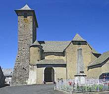
The Castle of Alpuech as well as that of Cantoin, the Barony of Benaven, and Lacalm castle all belonged to the County of Rodez. This gave the benefit to Alpuech of the monastery of Pebrac (Haute Loire) in 1215. The castle was destroyed in 1550. The oldest houses surround the church which is from the 11th century in the Roman style with a Latin cross. In good weather the bell tower has views over the Cantal Mountains. There are traces of Roman roads and also paths from the 16th century on the road to Vitrac and a remarkable "tau cross" from the 12th century north of the village.[4]
Administration
List of Successive Mayors of Alpuech[5]
| From | To | Name |
|---|---|---|
| 1793 | 1803 | Gailhac Bouldoires |
| 1804 | 1806 | Bertrand Vigouroux |
| 1806 | 1811 | Pierre Valadier |
| 1812 | 1841 | Gabriel Capoulade |
| 1841 | 1858 | Charles Noël |
| 1858 | 1876 | Edouard Noël |
| 1877 | 1884 | J. François Allie |
| 1884 | 1888 | Edouard Daude |
| 1888 | 1896 | Casimir Brevier |
| 1896 | 1902 | Ferdenand Noël |
| 1902 | 1908 | Edouard Daude |
| 1908 | 1912 | Guillaume Cambournac |
| 1912 | 1924 | Léon Allie |
| 1924 | 1928 | Cayla |
| 1928 | 1935 | Eugène Blancher |
- Mayors from 1935
| From | To | Name | Party | Position |
|---|---|---|---|---|
| 1935 | 1944 | Marius Dangles | ||
| 1944 | 1960 | Fernand Bouldoires | ||
| 1960 | 2008 | Jean Balitrand | ||
| 2008 | 2020 | André Raymond |
(Not all data is known)
Demography
In 2009 the commune had 82 inhabitants. The evolution of the number of inhabitants is known through the population censuses conducted in the town since 1793. From the 21st century, a census of municipalities with fewer than 10,000 inhabitants is held every five years, unlike larger towns that have a sample survey every year.[Note 1]
| 1793 | 1800 | 1806 | 1821 | 1831 | 1836 | 1841 | 1846 | 1851 |
|---|---|---|---|---|---|---|---|---|
| 750 | 371 | 896 | 820 | 819 | 1,006 | 518 | 542 | 475 |
| 1856 | 1861 | 1866 | 1872 | 1876 | 1881 | 1886 | 1891 | 1896 |
|---|---|---|---|---|---|---|---|---|
| 438 | 477 | 471 | 475 | 391 | 347 | 420 | 333 | 323 |
| 1901 | 1906 | 1911 | 1921 | 1926 | 1931 | 1936 | 1946 | 1954 |
|---|---|---|---|---|---|---|---|---|
| 325 | 304 | 304 | 259 | 251 | 235 | 239 | 203 | 185 |
| 1962 | 1968 | 1975 | 1982 | 1990 | 1999 | 2009 | - | - |
|---|---|---|---|---|---|---|---|---|
| 155 | 111 | 79 | 84 | 78 | 81 | 82 | - | - |
Sources : Ldh/EHESS/Cassini until 1962, INSEE database from 1968 (population without double counting and municipal population from 2006)

Sites and monuments
- The Church of Saint Martin (11th century)

Notable people linked to the Commune
- J.P. Bouyssou, known as the 'Thief of Alpuech' was an outlaw and Royalist who was a "Robin Hood" of the revolutionary era: he took from the rich to give to the poor.[4]
See also
External links
- Canton of Sainte Geneviève-sur-Argence tourism website (in French)
- Alpuech on Lion1906
- Alpuech on Google Maps
- Alpuech on Géoportail, National Geographic Institute (IGN) website (in French)
- Alpuech on the 1750 Cassini Map
- Alpuech on the INSEE website (in French)
- INSEE (in French)
Notes and references
Notes
- ↑ At the beginning of the 21st century, the methods of identification have been modified by law No. 2002-276 of 27 February 2002 Archived 2016-03-06 at the Wayback Machine., the so-called "law of local democracy" and in particular Title V "census operations" which allow, after a transitional period running from 2004 to 2008, the annual publication of the legal population of the different French administrative districts. For municipalities with a population greater than 10,000 inhabitants, a sample survey is conducted annually, the entire territory of these municipalities is taken into account at the end of the period of five years. The first "legal population" after 1999 under this new law came into force on 1 January 2009 and was based on the census of 2006.
References
- ↑ Arrêté préfectoral 18 November 2015
- ↑ Inhabitants of Aveyron (in French)
- 1 2 Google Maps
- 1 2 Tourist Site for Alpuech (in French)
- ↑ List of Mayors of France (in French)
- ↑ Ministry of Culture, Mérimée PA00093956 Church of Saint Martin (in French)
| Wikimedia Commons has media related to Alpuech. |