Al Barsha
| Al Barsha البرشاء | |
|---|---|
| Community | |
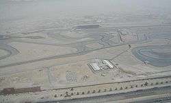 Dubai Autodrome and surrounding areas of Al Barsha | |
| Coordinates: 25°06′40″N 55°11′43″E / 25.11102°N 55.19514°ECoordinates: 25°06′40″N 55°11′43″E / 25.11102°N 55.19514°E | |
| Country | United Arab Emirates |
| Emirate | Dubai |
| City | Dubai |
| Established | 2000 |
| Area | |
| • Total | 38 km2 (15 sq mi) |
| Population [1] (2000) | |
| • Total | 1,248 |
| • Density | 33/km2 (85/sq mi) |
| Community number | 373-376, 671-673 |
- For the location in Egypt, see Deir el-Bersha.
Al Barsha (Arabic: البرشاء) is a collection of sub-communities in Dubai, United Arab Emirates (UAE). Al Barsha is one of the newer residential developments, and is located in west Dubai, south of Al Sufouh. Al Barsha is bounded by E 11 (Sheikh Zayed Road) and E 311 (Sheikh Mohammad Bin Zayed Road).
In 2018 Feb 20, Ci CORP FZE, a digital innovation company launched a portal for Al Barsha Community "Al Barsha Business Directory."
Its various subcommunities include:
- Al Barsha First
- Al Barsha Second
- Al Barsha Third
- Al Barsha South One
- Al Barsha South Two
- Al Barsha South Three
- Al Barsha Heights
A newly developed community, Al Barsha is still thinly populated when compared to other communities in the city. Al Barsha is close to Dubai Internet City, Dubai Marina and the Palm Jumeirah. Landmarks within Al Barsha include Mall of the Emirates and Dubai Autodrome.
Al Barsha is bounded to the north by Al Sufouh, to the west by Emirates Hills, the east by Al Quoz and to the south by Dubai Sports City and other property developments.
Schools
- Dubai National School
- Dubai American Academy
- American School of Dubai
- Gems World Academy
- Al Mawakeb School - Al Barsha[2]
References
- ↑ Existing Population and Future Holding Capacities in Dubai Urban Area Archived 2008-09-11 at the Wayback Machine.. Dubai Healthcare City. 2000
- ↑ "Al Mawakeb School - Al Barsha." Al Mawakeb Schools. Retrieved on November 15, 2015.
lies