Aknīste
| Aknīste | ||
|---|---|---|
| Town | ||
 Gates of the Sēļi Park | ||
| ||
 Aknīste Location in Latvia | ||
| Coordinates: 56°9′N 25°44′E / 56.150°N 25.733°ECoordinates: 56°9′N 25°44′E / 56.150°N 25.733°E | ||
| Country |
| |
| Municipality | Aknīste municipality | |
| Town rights | 1991 | |
| Area | ||
| • Total | 133 km2 (51 sq mi) | |
| Population | ||
| • Total | 1,133 | |
| • Density | 15/km2 (40/sq mi) | |
| Time zone | UTC+2 (EET) | |
| • Summer (DST) | UTC+3 (EEST) | |
| Postal code | LV-5208 | |
| Calling code | +371 652 | |

Aknīste (![]()
History
The town name, Aknīste, was first mentioned in 1298. From the 17th century the settlement was a panhandle of Lithuania and after the partitions of the Polish–Lithuanian Commonwealth part of the Kovno Governorate of the Russian Empire. Since 1918, part of Lithuania, but in the 1921, Lithuania exchanged Aknīste for Palanga.
The settlement was the site of a mass killing of Jewish residents, during the Nazi occupation of the Baltic states.[1] 98% of the approximately 140 Jews in Akniste before July 18, 1941 were killed, mostly by Latvian SS units before the Germans arrived in Akniste.[2]
In 1991, Aknīste was granted the town status.
 Aknīste catholic church. Built in the 1930s
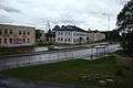 Aknīste town center
 Aknīste secondary school (Built in the 1930s)
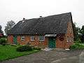 Aknīste local history museum
See also
References
| Wikimedia Commons has media related to Aknīste. |