Bilhorod-Dnistrovskyi
| Bilhorod-Dnistrovskyi Білгород-Дністровський | |||
|---|---|---|---|
| City of regional significance | |||
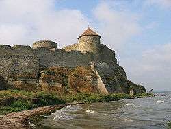 Akkerman fortress | |||
| |||
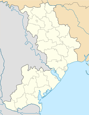 Bilhorod-Dnistrovskyi Location in Ukraine  Bilhorod-Dnistrovskyi Bilhorod-Dnistrovskyi (Ukraine) | |||
| Coordinates: 46°11′32″N 30°20′00″E / 46.19222°N 30.33333°E | |||
| Country |
| ||
| Oblast |
| ||
| Municipality | Bilhorod-Dnistrovskyi | ||
| Area | |||
| • Total | 31 km2 (12 sq mi) | ||
| Elevation | 28 m (92 ft) | ||
| Population (2015)[1] | |||
| • Total | 50,086 | ||
| Time zone | UTC+2 (EET) | ||
| • Summer (DST) | UTC+3 (EEST) | ||
| Postal code | 67700—67719 | ||
| Area code(s) | +380 4849 | ||
| Climate | Cfb | ||
| Website | www.bilgorod-d.org.ua | ||
.svg.png)
Bilhorod-Dnistrovskyi (Ukrainian: Білгород-Дністровський, Romanian: Cetatea Albă, Russian: Бе́лгород-Днестро́вский ), formerly known as Akkerman (see naming section below), is a city and port situated on the right bank of the Dniester Liman (on the Dniester estuary leading to the Black Sea[2]) in Odessa Oblast of southwestern Ukraine, in the historical region of Bessarabia. Administratively, Bilhorod-Dnistrovskyi is incorporated as a town of oblast significance. It also serves as the administrative center of Bilhorod-Dnistrovskyi Raion, one of twenty-six districts of Odessa Oblast, though it is not a part of the district. It is a location of a big freight seaport. Population: 50,086 (2015 est.)[3]
Nomenclature
The city of Bilhorod-Dnistrovskyi is also referred to by alternative transliterations from Ukrainian as Bilhorod-Dnistrovsky or Bilhorod-Dnistrovskyy. Dnistrovsky was added to differentiate it from Bilhorod that was part of the Sloboda Ukraine and carried a similar name.
- Previous names
- Ophiusa (Οφιούσα), Phoenician colony
- Tyras (Τύρας), Ancient Greek (Classical Greece) colony (also the Greek name for the River Dniester)
- Asprokastron (Ἀσπρόκαστρον, "White Castle"), Greek name in Antiquity and the Middle Ages[4] Name attested from 944-1484 AD.
- Maurokastron (Μαυρόκαστρον, "Black Castle"), Greek name of a Roman/Byzantine fort in Late Antiquity on a site directly opposite Asprokastron, but usually taken together.[4]
- Album Castrum ("White Castle"), Latin name
- Cetatea Albă ("White Citadel"), Romanian name
- Moncastro, Italian corruption of Maurokastron used by Genoese traders and during Genoese rule (14th–15th centuries)[4]
- Turla, Turkic
- Akkerman, Ottoman Turkish ("White Rock")
- Belgorod-Dnestrovskiy, Russian (Бе́лгород-Днестро́вский, "White city on the Dniester")
The town became part of the Principality of Moldavia in 1359. The fortress was enlarged and rebuilt in 1407 under Alexander the Kind and in 1440 under Stephen II of Moldavia.[2] It fell to Ottoman conquest on August 5, 1487. From 1503 to 1941, the city was known by its Romanian name of Cetatea Albă, literally "white citadel".[2] Since 1944 the city has been known as "Bilhorod-Dnistrovskyi" (Білгород-Дністровський), while on the Soviet geography maps often translated into its Russian equivalent of "Belgorod-Dnestrovskiy" (Бе́лгород-Днестро́вский), literally "white city on the Dniester".
The city is known by translations of "white city" or "white rock" in a number of languages including Белгород Днестровски (Belgorod-Dnestrovski) in Bulgarian, Akerman (Акерман) in Gagauz, Białogród nad Dniestrem in Polish, Walachisch Weißenburg in German,[5] Dnyeszterfehérvár in Hungarian and עיר לבן (Ir Lavan) in Hebrew.
In Western European languages, including English, the city has typically been known by the official name of the time or a transliteration derived from it.
History
.svg.png)
In the 6th century BC, Milesian colonists founded a settlement named Tyras on the future location of Bilhorod-Dnistrovskyi, which later came under Roman and Byzantine rule. In Late Antiquity, the Byzantines built a fortress and named it Asprokastron ("White Castle" - a meaning kept in several languages), but it passed out of their control in the 7th-10th centuries, but appears to have been re-established by the mid-11th century.[4] The Voskresensk Chronicle lists Bilhorod "at the mouth of the Dniester, above the sea" among the towns controlled by Kievan Rus.
In the 13th century the site was controlled by the Cumans, and became a center of Genoese commercial activity from c. 1290 on. Briefly held by the Second Bulgarian Empire in the early 14th century, by the middle of the century it was a Genoese colony.[4] Sfântul Ioan cel Nou (Saint John the New), the patron saint of Moldavia, was martyred in the city in 1330 during a Tatar incursion. In 1391, Cetatea Albă was the last city on the right bank of the Dnister to be incorporated into the newly established Principality of Moldavia, and for the next century was its second major city, the major port and an important fortress.
In 1420, the citadel was attacked for the first time by the Ottomans, but defended successfully by Moldavian Prince Alexander the Kind.
In the 15th century, the port saw much commercial traffic as well as being frequently used for passenger traffic between central Europe and Constantinople. Among the travellers who passed through the town was John VIII Palaiologos.[4] Following the Fall of Constantinople to the Ottomans in 1453, Sultan Mehmed II brought in colonists from Asprokastron to repopulate the city.[4]
In 1484, along with Kilia, it was the last of the Black Sea ports to be conquered by the Ottomans.[4] The Moldavian prince Stephen the Great was unable to aid in its defence, being under threat of a Polish invasion. The citadel surrendered when the Ottomans claimed to have reached an agreement with Prince Stephen, and promised safe passage to the inhabitants and their belongings; however, most of the city-dwellers were slaughtered. Later, attempts by Stephen the Great to restore his rule over the area were unsuccessful. Cetatea Albă was subsequently a base from which the Ottomans were able to attack Moldavia proper. In 1485, Tatars setting out from this city founded Pazardzhik in Bulgaria.
It was established as the fortress of Akkerman, part of the Ottoman defensive system against Poland-Lithuania and, later, the Russian Empire. Major battles between the Ottomans and the Russians were fought near Akkerman in 1770 and 1789. Russia conquered the town in 1770, 1774, and 1806, but returned it after the conclusion of hostilities.[6] It was not incorporated into Russia until 1812, along with the rest of Bessarabia.
On 25 September 1826, Russia and the Ottomans signed here the Akkerman Convention which imposed that the hospodars of Moldavia and Wallachia be elected by their respective Divans for seven-year terms, with the approval of both Powers.
During the Russian Revolution, Akkerman was alternatively under the control of the Ukrainian People's Republic and troops loyal to the government of Soviet Russia. Furthermore, the city and the surrounding district were also claimed by the Moldovan Democratic Republic, which however had no means to enforce such claims on the ground. The city was occupied by the Romanian Army on 9 March 1918, after heavy fighting with local troops led by the Bolsheviks. Formal integration followed later that month, when an assembly of the Moldovan Democratic Republic proclaimed the whole of Bessarabia united with Romania. In the interwar period, projects aimed to expand the city and the port were reviewed. Romania ceded the city to the Soviet Union on 28 June 1940 following the 1940 Soviet Ultimatum, but regained it on 28 July 1941 during the invasion of the USSR by the Axis forces in the course of the Second World War and had it within its boundaries until 22 August 1944 when the Red Army occupied the city once again. The Soviets partitioned Bessarabia, and its southern flanks (including Bilhorod) became part of the Ukrainian SSR, and after 1991, modern Ukraine.
Jewish history
In Jewish sources, the city is referred as Weissenburg and Ir Lavan (both meaning "white city"). Karaite Jews lived there since the 16th century, some even claim the existence of khazars Jews in town as early as the 10th century. In 1897, 5,613 Jews lived in the city (19.9% of the total population). The town Jewish community was influenced mainly from the Jewish community of nearby Odessa. During a pogrom in 1905, eight Jews living in the city were killed. During World War II, most of the Jews living in the city fled to nearby Odessa, where they were later killed. The 800 Jews who were left in the city were shot to death in the nearby Leman river.[7] Around 500 of the prewar town Jews survived the war, and around half of them returned to the city.
Demographics
As of 1920, the population was estimated at 35,000. 8,000 were Romanian, 8,000 were Jewish, and 5,000 were German. Additional populations included Turks, Greeks, Bulgarians and Russians.[2]
According to the 2001 Ukrainian census,[8] the majority of the city's population are Ukrainians (63%). Other important communities include Russians (28%), Bulgarians (3.7%) and Moldovans (1.9%). The language situation is notably different, with Russian-speakers representing a majority (54%), followed by speakers of Ukrainian (42%), Bulgarian (1.6%) and Moldovan (1.3%). As is common in Ukraine, Russian is the most common language spoken in public in the city, although public signs are in Ukrainian.
Government
Serving as the administrative center of the Bilhorod-Dnistrovskyi Raion (district), Bilhorod-Dnistrovskyi itself is a city of oblast subordinance, thus being subject directly to the oblast authorities rather to the raion administration housed in the city itself. The city also administers two towns Serhiyivka and Zatoka.
Climate
Bilhorod-Dnistrovskyi has an humid continental climate (Köppen: Dfb bordering on Dfa.).
| Climate data for Bilhorod-Dnistrovskyi | |||||||||||||
|---|---|---|---|---|---|---|---|---|---|---|---|---|---|
| Month | Jan | Feb | Mar | Apr | May | Jun | Jul | Aug | Sep | Oct | Nov | Dec | Year |
| Average high °C (°F) | 1.5 (34.7) |
2.1 (35.8) |
5.9 (42.6) |
12.9 (55.2) |
19.1 (66.4) |
23.5 (74.3) |
25.9 (78.6) |
25.5 (77.9) |
21.2 (70.2) |
15.1 (59.2) |
8.9 (48) |
4.4 (39.9) |
13.8 (56.9) |
| Daily mean °C (°F) | −1.1 (30) |
−0.4 (31.3) |
3.1 (37.6) |
9.6 (49.3) |
15.6 (60.1) |
19.7 (67.5) |
21.9 (71.4) |
21.5 (70.7) |
17.3 (63.1) |
11.6 (52.9) |
6.1 (43) |
1.8 (35.2) |
10.6 (51.1) |
| Average low °C (°F) | −3.7 (25.3) |
−2.9 (26.8) |
0.4 (32.7) |
6.4 (43.5) |
12.1 (53.8) |
16.0 (60.8) |
17.9 (64.2) |
17.5 (63.5) |
13.5 (56.3) |
8.2 (46.8) |
3.4 (38.1) |
−0.7 (30.7) |
7.3 (45.2) |
| Average precipitation mm (inches) | 35 (1.38) |
36 (1.42) |
27 (1.06) |
31 (1.22) |
39 (1.54) |
48 (1.89) |
49 (1.93) |
36 (1.42) |
38 (1.5) |
25 (0.98) |
38 (1.5) |
42 (1.65) |
444 (17.49) |
| Source: Climate-Data.org[9] | |||||||||||||
People from Bilhorod-Dnistrovskyi
- Nicolas Astrinidis (1921-2010), composer who settled in Greece
- Elena Cernei (1924–2000), Romanian opera singer
- Tamara Tchinarova Finch (born 1919), a retired ballet dancer
- Vasyl Lomachenko (born 1988), Ukrainian professional boxer
- Jacques Roitfeld (1889–1999), French film producer
- Porfiriy Stamatov (1840–1925), Minister of Justice of Bulgaria (1881)
- Nicolae Văcăroiu (born 1943), former Prime Minister of Romania
- Osip Yermansky (1867-1941), Menshevik economist
Gallery
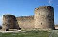 The inner part of fortress Akkerman.
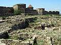 The excavations in front of Akkerman.
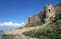 The fortress Akkerman from the sea.
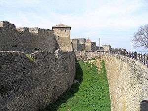 The walls of Fortress Akkerman.
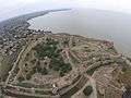 Aerial photo of the Akkerman fortress.
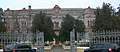 High school building in Bilhorod-Dnistrovs'kyj
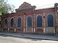 Synagogue
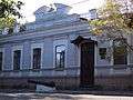 Local museum
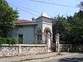 Jaroszewicz Manor
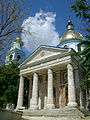 Ascension Cathedral
.JPG) St. John Church
St. John Church St. Nicholas Church
.JPG) Armenian Dormition Church (14th century)
Armenian Dormition Church (14th century) Temple of Salvation and a shopping center at Bilhorod-Dnistrovskyi
See also
References
- ↑ Державний комітет статистики України. Чисельність наявного населення України на 1 січня 2011 року, Київ-2011 (doc) Archived 10 October 2012 at the Wayback Machine.
- 1 2 3 4 Kaba, John (1919). Politico-economic Review of Basarabia. United States: American Relief Administration. p. 15.
- ↑ "Чисельність наявного населення України (Actual population of Ukraine)" (PDF) (in Ukrainian). State Statistics Service of Ukraine. Retrieved 1 July 2016.
- 1 2 3 4 5 6 7 8 Browning, Robert (1991). "Asprokastron". In Kazhdan, Alexander. The Oxford Dictionary of Byzantium. Oxford and New York: Oxford University Press. p. 212. ISBN 978-0-19-504652-6.
- ↑ Hans Miksch. Wien— das Stalingrad der Osmanen. Volume 3 of Der Kampf der Kaiser und Kalifen. Bernard & Graefe, 1992. ISBN 9783763754717 p. 106.
- ↑ Chisholm, Hugh, ed. (1911). "Akkerman". Encyclopædia Britannica. 1 (11th ed.). Cambridge University Press. p. 457.
- ↑ "Gale - Product Login". go.galegroup.com.
- ↑ "All-Ukrainian population census-". www.ukrcensus.gov.ua.
- ↑ "Climate: Bilhorod-Dnistrovskyi". Climate-Data.org. Retrieved 4 May 2014.
External links
![]()
| Cities | ||
|---|---|---|
| Urban-type settlements |
| |
| Raions | |||||
|---|---|---|---|---|---|
| Cities |
| ||||
| |||||