Aji River (Gujarat)
| Aji River (આજી નદી) | |
| River | |
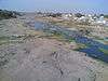 View of river basin from railway bridge at Rajkot | |
| Country | India |
|---|---|
| State | Gujarat |
| Region | Saurashtra |
| Districts | Rajkot district, Jamnagar district |
| Tributaries | |
| - left | Nyari River |
| City | Rajkot |
| Landmark | Aji Dam 1 (Aji Dam 2) ( Aji Dam 3) |
| Source | |
| - location | Jasdan mountain range, Rajkot district, Gujarat, India near tramba village
|
| Mouth | Gulf of Kutch, Arabian Sea |
| - location | Ranjitpara [1], Jamnagar, Gujarat, India |
| Length | 164 km (102 mi) |
- For other rivers of same name, see Aji River (disambiguation)
Aji River is one of the main rivers of saurashtra (region), Gujarat State. It is called the lifeline of Rajkot City and separates Rajkot in east-west parts.[2] There are four dams on Aji River, the water from which is used for agriculture and as drinking water.
Purification Project
Rajkot Municipal Corporation has started project for the purification of Aji River and to provide retaining walls and plantations at both ends.[3] Originating from the hilly areas of Sardhar and Hingolgadh, it has a length of 250 km and flows into the Gulf of Kutch. Some of the major tributaries of Aji are the Nyari, Khokaldadi, Bhankudi & Dondi rivers originating from the hills of Sardhar near Atkot. There are major irrigation projects on Aji, but none of them support any canal system for irrigation.
But recently in June 2017, the Prime minister inaugurated the filling of Aji dam near Rajkot under Sauni Yojana. Sauni stands for Saurashtra Narmada Avtaran Irrigation, is envisaged to fill dams across Shaurashtra by diverting floodwaters from Sardar Sarovar dam acroos Narmada river, through pipelines.
References
- ↑ "Mouth Location", Retrieved on 14 January 2008
- ↑ "Rajkot and Aji River Archived 24 December 2007 at the Wayback Machine.", Retrieved on 14 January 2008
- ↑ "Purification Project". Retrieved on 14 January 2008
Coordinates: 22°56′N 70°28′E / 22.933°N 70.467°E