Ayni District
| Ayni District Ноҳияи Айнӣ | |
|---|---|
| District | |
| Ноҳияи Айнӣ | |
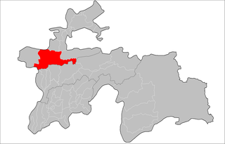 Location of Ayni District in Tajikistan | |
| Country |
|
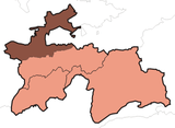
| Province | Sughd |
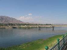
| Capital | Ayni |
| Time zone | UTC+5 (TJT) |
| Postal code | 735520 |
| Area code(s) | +992 3479 |
| Website | http://aini.tj |
Ayni District, also Aini District (Tajik: Ноҳияи Айнӣ, Nohiyayi Aynī), is a district in the southern part of Sughd province, Tajikistan, straddling the middle course of the Zeravshan River. Its capital is the town of Ayni (Tajik: Айнӣ), located on the Zeravshan.[1] Named after the Tajik national poet Sadriddin Ayni (Tajik: Садриддин Айнӣ). India established a base at Ayni in Tajikistan, which was used to assist the Northern Alliance during the Taliban regime.
Administrative divisions
The district is divided administratively into jamoats. They are as follows (and population).[2]
| Jamoats of Aini District | |||||||||||
| Jamoat | Population | ||||||||||
|---|---|---|---|---|---|---|---|---|---|---|---|
| Anzob | 7016 | ||||||||||
| Ayni | 12131 | ||||||||||
| Dardar | 6534 | ||||||||||
| Fondaryo | 7310 | ||||||||||
| Rarz | 8507 | ||||||||||
| Shamtuch | 6055 | ||||||||||
| Urmetan | 14849 | ||||||||||
| Zarafshan | 57493 | ||||||||||
References
- ↑ Republic of Tajikistan, map showing administrative division as of January 1, 2004, "Tojjikoinot" Cartographic Press, Dushanbe
- ↑ "List of Jamoats". UN Coordination, Tajikistan. Archived from the original on 26 February 2012.
External links
- "Map of Zarafshan Valley showing Ayni District and jamoats" (PDF). UN Development Programme. Archived from the original (PDF) on 2012-06-04.
This article is issued from
Wikipedia.
The text is licensed under Creative Commons - Attribution - Sharealike.
Additional terms may apply for the media files.