Cebollatí River
| Cebollatí River | |
|---|---|
 | |
| Country | Uruguay |
| Physical characteristics | |
| Length | 235 kilometres (146 mi) |
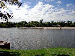
The Cebollatí River is a Uruguayan river that rises in Cuchilla Grande (Big Ridge), flows southwest to northeast and forms a border between Treinta y Tres and Rocha.
Features and location
At roughly 235 kilometres (146 mi), it is one of the longest rivers in Uruguay.
It joins the Rio Olimar Grande and flows into the Merin Lagoon in Treinta y Tres.
In October 2009 the National Hydrographic Institute of Uruguay started operating a free raft service across the Cebollatí River; this service allows commuters to cross from Treinta y Tres to Rocha in a wooden raft between the localities of Cebollatí and Charqueada.[1]
See also
References
External links
| Wikimedia Commons has media related to Río Cebollatí. |
- Rand McNally, The New International Atlas, 1993.
- GEOnet Names Server
Coordinates: 33°09′21″S 53°38′18″W / 33.15583°S 53.63833°W
This article is issued from
Wikipedia.
The text is licensed under Creative Commons - Attribution - Sharealike.
Additional terms may apply for the media files.