Aguereberry Point
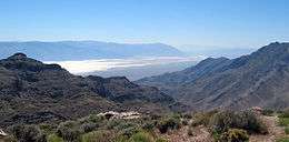
Badwater Basin from Aguereberry Point
Aguereberry Point is a promontory and tourist viewpoint in the Panamint Range, within Death Valley National Park in Inyo County, eastern California.
The point's elevation reaches 6,433 ft and is named for Jean Pierre "Pete" Aguereberry, a Basque miner who was born in 1874, emigrated from France in 1890, and lived at and worked the nearby Eureka Mine from 1905 to his death in 1945.[1][2]
From this viewpoint, one can see the surrounding Panamint Range extending to the north and south; Death Valley to the east, with Furnace Creek and the salt flats of Badwater Basin to the southeast; and Mount Charleston in Nevada far to the east.[3]
See also
- Panamint Range topics
References
- ↑ "Pete Aguereberry". National Park Service. Retrieved 20 January 2012.
- ↑ William Bright; Erwin Gustav Gudde (30 November 1998). 1500 California place names: their origin and meaning. University of California Press. p. 11. ISBN 978-0-520-21271-8. Retrieved 20 January 2012.
- ↑ Walter Feller. "Aguereberry Point". Panamint Springs Area. Digital Desert. Retrieved 20 January 2012.
External links
| Wikimedia Commons has media related to Aguereberry Point. |
Coordinates: 36°21′28″N 117°02′53″W / 36.35778°N 117.04806°W
This article is issued from
Wikipedia.
The text is licensed under Creative Commons - Attribution - Sharealike.
Additional terms may apply for the media files.