Aeroflex–Andover Airport
| Aeroflex–Andover Airport | |||||||||||
|---|---|---|---|---|---|---|---|---|---|---|---|
 | |||||||||||
| Summary | |||||||||||
| Airport type | Public use | ||||||||||
| Owner | New Jersey Forest Fire Service | ||||||||||
| Operator | John T. Flyntz | ||||||||||
| Serves | Andover, New Jersey | ||||||||||
| Location | Sussex County, New Jersey | ||||||||||
| Elevation AMSL | 583 ft / 178 m | ||||||||||
| Coordinates | 41°00′31.031″N 074°44′16.922″W / 41.00861972°N 74.73803389°WCoordinates: 41°00′31.031″N 074°44′16.922″W / 41.00861972°N 74.73803389°W | ||||||||||
| Website | New Jersey State Forest Fire Service | ||||||||||
| Runways | |||||||||||
| |||||||||||
| Statistics (2010) | |||||||||||
| |||||||||||
Aeroflex–Andover Airport (FAA LID: 12N) is a public-use airport located two nautical miles (3.704 km) north of Andover within Kittatinny Valley State Park in Sussex County, New Jersey, United States.[2][3][4] The airport is publicly owned by the New Jersey Forest Fire Service[1] and used as a base for aerial wildfire suppression.
Facilities and aircraft
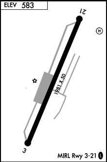
Aeroflex–Andover Airport covers an area of 12 acres (4.9 ha) at an elevation of 583 feet (178 m) above mean sea level. It has one runway designated 03/21 with an asphalt surface measuring 1,981 by 50 feet (604 x 15 m).[1]
For the 12-month period ending January 1, 2010, the airport had 24,826 aircraft operations, an average of 68 per day: 100% general aviation. At that time there were 48 aircraft based at this airport: 98% single-engine and 2% helicopter.[1]
See also
References
- 1 2 3 4 FAA Airport Master Record for 12N (Form 5010 PDF), effective 2012-02-09
- ↑ Federal Aviation Administration, National Flight Data Center for Aeroflex–Andover Airport (12N). Retrieved July 18, 2015.
- ↑ "Aeroflex–Andover Airport – 12N". Aircraft Owners and Pilots Association. Retrieved 27 July 2015.
External links
- FAA Terminal Procedures for 12N, effective September 13, 2018
- Resources for this airport:
- FAA airport information for 12N
- AirNav airport information for 12N
- FlightAware airport information and live flight tracker
- SkyVector aeronautical chart for 12N
- New Jersey Forest Fire Service