Aerial Bay Islands
 Aerial Bay Islands Location of Aerial Bay Islands | |
| Geography | |
|---|---|
| Location | Bay of Bengal |
| Coordinates | 13°18′N 93°02′E / 13.30°N 93.03°ECoordinates: 13°18′N 93°02′E / 13.30°N 93.03°E |
| Archipelago | Andaman Islands |
| Adjacent bodies of water | Indian Ocean |
| Total islands | 10 |
| Major islands |
|
| Area | 23.35 km2 (9.02 sq mi)[1] |
| Highest elevation | 131 m (430 ft)[2] |
| Administration | |
| District | North and Middle Andaman |
| Island group | Andaman Islands |
| Island sub-group | Aerial Bay Islands |
| Taluk | Diglipur Taluk |
| Largest settlement | Smith (pop. 260) |
| Demographics | |
| Population | 600 (2011) |
| Pop. density | 25.7 /km2 (66.6 /sq mi) |
| Ethnic groups | Hindu, Andamanese |
| Additional information | |
| Time zone | |
| PIN | 744202[3] |
| Telephone code | 031927 [4] |
| ISO code | IN-AN-00[5] |
| Official website |
www |
| Literacy | 71.8% |
| Avg. summer temperature | 30.2 °C (86.4 °F) |
| Avg. winter temperature | 23.0 °C (73.4 °F) |
| Sex ratio | 1.2♂/♀ |
| Census Code | 35.639.0004 |
| Official Languages | Hindi, English |
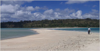
The Aerial Bay Islands are a group of islands in Aerial Bay in the Andaman Islands. This group belongs to the North and Middle Andaman administrative district, part of the Indian union territory of Andaman and Nicobar Islands.[6] Smith Island is the largest and only inhabited one.
Geography
Other major islands are Chatham island, Ross Island, Ox Island.[7]
Administration
Demographics
There are 3 villages on Smith island, with a population of 600.
References
- ↑ "Islandwise Area and Population - 2011 Census" (PDF). Government of Andaman.
- ↑ "Sailing Directions (enroute) | India and the Bay of Bengal" (PDF) (173). National Geospatial-intelligence Agency, United States Government. 2014. Retrieved 2016-09-23.
- ↑ "A&N Islands - Pincodes". 2016-09-22. Archived from the original on 2014-03-23. Retrieved 2016-09-22.
- ↑ "STD Codes of Andaman and Nicobar". allcodesindia.in. Retrieved 2016-09-23.
- ↑ Registration Plate Numbers added to ISO Code
- ↑ "Village Code Directory: Andaman & Nicobar Islands" (PDF). Census of India. Retrieved 2011-01-16.
- ↑ pic
- ↑ "DEMOGRAPHIC – A&N ISLANDS" (PDF). andssw1.and.nic.in. Retrieved 2016-09-23.
This article is issued from
Wikipedia.
The text is licensed under Creative Commons - Attribution - Sharealike.
Additional terms may apply for the media files.