Advance, North Carolina
| Advance, North Carolina | |
|---|---|
| Census-designated place | |
 Advance Location in North Carolina | |
| Coordinates: 35°56′28″N 80°24′35″W / 35.94111°N 80.40972°WCoordinates: 35°56′28″N 80°24′35″W / 35.94111°N 80.40972°W | |
| Country | United States |
| State | North Carolina |
| County | Davie |
| Area | |
| • Total | 7.2 sq mi (18.7 km2) |
| • Land | 7.1 sq mi (18.5 km2) |
| • Water | 0.08 sq mi (0.2 km2) |
| Elevation | 831 ft (253 m) |
| Population (2010) | |
| • Total | 1,138 |
| • Density | 159/sq mi (61.4/km2) |
| Time zone | UTC-5 (Eastern (EST)) |
| • Summer (DST) | UTC-4 (EDT) |
| ZIP code | 27006 |
| Area code(s) | 336 |
| FIPS code | 37-00440[1] |
| GNIS feature ID | 1018774[2] |
Advance (pronounced with the stress on the first syllable) is an unincorporated community and census-designated place (CDP) in Davie County, North Carolina, United States. It is seventy-five miles northeast of Charlotte. As of the 2010 census it had a population of 1,138.[1] It is located along North Carolina Highway 801 just south of Bermuda Run. Advance is part of the Piedmont Triad region of North Carolina.
Geography
Advance is located in eastern Davie County. The Yadkin River forms the eastern edge of the CDP and is the Davidson County line. According to the U.S. Census Bureau, the CDP has a total area of 7.2 square miles (18.7 km2), of which 7.1 square miles (18.5 km2) is land and 0.1 square miles (0.2 km2), or 0.95%, is water.[1] Neighboring communities and municipalities include Bermuda Run, 4 miles (6 km) to the north, and Mocksville, the Davie County seat, 11 miles (18 km) to the west. The largest neighboring city is Winston-Salem, NC.
Advance is home to Shady Grove Elementary School and William Ellis Middle School.
Name origin
Various accounts exist for the origin of the town's name. Some suggest the name was derived from the name of a popular resident and freed slave, Samuel Vance Allen. Other accounts suggest the community was named by residents who hoped that with the addition of a post office, the community would advance.
Encompassing communities
While Advance remains unincorporated, it is recognized by the US Postal Service under ZIP code 27006. The common area of Advance includes several smaller unincorporated communities that are not recognized by the Postal Service:
- Bixby
- Cornatzer
- Farmington (south of Spillman Road)
- Fork Church
- Fulton
- Hillsdale
- Redland
- Shady Grove
- Smith Grove
Housing developments include Oak Valley, Underpass Road Communities (Greenwood Lakes, Westridge, Countryside, Eastside), Hidden Creek, and others. [3]
Progress
The Advance population has grown at an accelerated pace within the past 10 years, with Advance evolving from a rural community into a more suburban bedroom community of Clemmons and Winston-Salem. Numerous housing developments have popped up on once-vibrant farmland, but Advance's small town character still shines through.
Local businesses
Advance has had several businesses that were prominent through its history. A few of these include:
- 801 Shell
- Advance Barber Shop
- Advance Car Wash (building still standing, but the business has long been closed down)
- Advance Country Store
- Advance Florist
- Advance Video - (no longer in business) known locally as Jitter's.
- Allen Geomatics - a Land Surveying firm
- Jeffco - a salon equipment and fixture company
- L&G Hair Design - (closed)
- Sparkle Clean Pools - Swimming pool services
- Tucker's Place restaurant - located in the building that once housed Advance Video
- Vogler's TV & VCR Service - a television repair shop
- Wright Farm Gates - a farm and ranch equipment distribution company
Schools and civic service
- Advance Masonic Lodge
- Advance Volunteer Fire Department
- Davie Civitan Club
- Cornatzer Elementary School
- Macedonia Moravian Preschool
- Shady Grove Elementary School
- William Ellis Middle School
- Davidson County Community College, Kinderton Campus
Churches
- Advance Baptist Church
- Advance United Methodist Church
- Bethlehem United Methodist Church [4]
- Calvary Baptist Church, West Campus (March 2009)
- Elbaville Methodist Church
- Hillsdale Baptist Church
- Hillsdale United Methodist Church
- Macedonia Moravian Church
- Mocks United Methodist Church
- Piney Grove United Methodist Church
- Redland Church Of Christ
- Redland Pentecostal Holiness Church
- Yadkin Valley Baptist Church
Landmarks
One significant landmark in the Advance area is the Vestal Potts Gymnasium. The basketball gymnasium is named after legendary coach Vestal Potts who coached Shady Grove's basketball teams to numerous championships.
Fulton United Methodist Church and John Edward Belle Shutt House and Outbuildings are listed on the National Register of Historic Places.[5]
References
- 1 2 3 "Geographic Identifiers: 2010 Demographic Profile Data (G001): Advance CDP, North Carolina". U.S. Census Bureau, American Factfinder. Retrieved November 30, 2015.
- ↑ U.S. Geological Survey Geographic Names Information System: Advance, North Carolina
- ↑ https://www.facebook.com/search/top/?q=underpass%20road%20communities
- ↑ 321 Redland Road, Advance, NC 27006
- ↑ National Park Service (2010-07-09). "National Register Information System". National Register of Historic Places. National Park Service.
External links
Municipalities and communities of Davie County, North Carolina, United States | ||
|---|---|---|
| Towns | 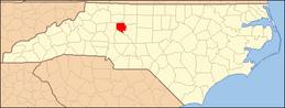 | |
| CDP | ||
| Unincorporated communities | ||