Acholibur
| Acholibur | |
|---|---|
 Acholibur Location in Uganda Placement on map is approximate | |
| Coordinates: 03°08′37″N 32°54′49″E / 3.14361°N 32.91361°ECoordinates: 03°08′37″N 32°54′49″E / 3.14361°N 32.91361°E | |
| Country |
|
| Region | Northern Region of Uganda |
| District | Pader District |
| Municipality | Acholibur |
| Elevation | 3,810 ft (1,160 m) |
Acholibur is a town in Pader District in the Northern Region of Uganda.
Location
Acholibur is approximately 19 kilometres (12 mi), by road, south of Kitgum, the nearest large urban centre.[1] The coordinates of Acholibur are 03°08'37.0"N, 32°54'49.0"E (Latitude:3.143611; Longitude:32.913611).[2]
Points of interest
These are some of the points of interest in or near Acholibur:
- offices of the Acholibur Town Council
- headquarters of the Acholibur sub-county
- northern end of the Acholibur–Gulu–Olwiyo Road
- Rwekunye–Apac–Aduku–Lira–Kitgum–Musingo Road, passing through town in a generally north/south direction
See also
References
- ↑ GFC (16 July 2015). "Road Distance Between Kitgum And Acholibur With Map". Globefeed.com (GFC). Retrieved 16 July 2015.
- ↑ Google (16 July 2015). "Location of Acholibur at Google Maps" (Map). Google Maps. Google. Retrieved 16 July 2015.
External links
- [ ]
Capital: Pader | ||
| Towns and villages | 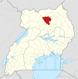 | |
| Economy | ||
| Energy | ||
| Education |
| |
| Transport | ||
| Notable people |
| |
This article is issued from
Wikipedia.
The text is licensed under Creative Commons - Attribution - Sharealike.
Additional terms may apply for the media files.