Achnasheen railway station
| Achnasheen | |
|---|---|
| Scottish Gaelic: Achadh na Sìne[1] | |
 | |
| Location | |
| Place | Achnasheen |
| Local authority | Highland |
| Coordinates | 57°34′45″N 5°04′20″W / 57.5793°N 5.0723°WCoordinates: 57°34′45″N 5°04′20″W / 57.5793°N 5.0723°W |
| Grid reference | NH164585 |
| Operations | |
| Station code | ACN |
| Managed by | Abellio ScotRail |
| Number of platforms | 2 |
| DfT category | F2 |
|
Live arrivals/departures, station information and onward connections from National Rail Enquiries | |
| Annual rail passenger usage* | |
| 2012/13 |
|
| 2013/14 |
|
| 2014/15 |
|
| 2015/16 |
|
| 2016/17 |
|
| History | |
| Original company | Dingwall and Skye Railway |
| Pre-grouping | Highland Railway |
| Post-grouping | LMSR |
| 19 August 1870 | Station opened[2] |
| National Rail – UK railway stations | |
| * Annual estimated passenger usage based on sales of tickets in stated financial year(s) which end or originate at Achnasheen from Office of Rail and Road statistics. Methodology may vary year on year. | |
|
| |
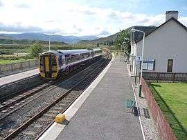
Achnasheen railway station is a remote railway station on the Kyle of Lochalsh Line, serving the village of Achnasheen in the north of Scotland.
The station is 27 miles 72 chains (44.9 km) from Dingwall, and has a passing loop 28 chains (560 m) long, flanked by two platforms. Platform 1 on the up (eastbound) line can accommodate trains having three coaches, whereas platform 2 on the down (westbound) line can hold five.[3]
History

The station was opened by the Dingwall and Skye Railway on 19 August 1870,[2] but operated from the outset by the Highland Railway. The station hotel was built by Alexander Ross and opened in 1871. It was extended by William Roberts in 1898[4] and again at the turn of the 21st century.
Taken into the London, Midland and Scottish Railway during the Grouping of 1923, the line then passed on to the Scottish Region of British Railways on nationalisation in 1948.
It was once an important railhead, handling passengers, mail and freight bound for parts of Wester Ross, including Gairloch and the Loch Torridon area. A proposal for a 35-mile-long (56 km) branch line to Aultbea, via Gairloch and Poolewe. Plans for the Loch Maree and Aultbea Railway was put to Parliament in 1893, but the proposal was rejected, as it deemed that the line would not be commercially viable in such a remote area. All freight in this area now travels by road. The station building still serves as a postal distribution point, but the mail travels from Inverness by road.
When sectorisation was introduced by British Rail, the station became part of ScotRail until the Privatisation of British Rail.
The station is the location of one of the three passing loops on the line west of Dingwall and trains are sometimes timetabled to cross here. The loop was once controlled from signal boxes at each end of the station (a common method of working on the HR), but both were closed when Radio Electronic Token Block signalling was introduced by British Rail on the line in 1984. The loop is now supervised remotely from the power box at Inverness.
Services
There are four trains a day in each direction (one or two on Sundays depending on the time of year) stopping here, connecting Achnasheen with all stations between Inverness and Kyle of Lochalsh.[5]
| Preceding station | Following station | |||
|---|---|---|---|---|
| Achanalt | Abellio ScotRail Kyle of Lochalsh Line |
Achnashellach | ||
| Historical railways | ||||
| Achanalt Line and Station open |
Highland Railway Dingwall and Skye Railway |
Glencarron Platform Line open; Station closed | ||
References
Notes
- ↑ Brailsford 2017, Gaelic/English Station Index.
- 1 2 Butt (1995)
- ↑ Brailsford 2017, map 22E.
- ↑ The Buildings of Scotland: Highlands: John Gifford. Yale University Press 2003. ISBN 0300096259 p.380
- ↑ GB eNRT May 2016, Table 239
Sources
- Brailsford, Martyn, ed. (December 2017) [1987]. Railway Track Diagrams 1: Scotland & Isle of Man (6th ed.). Frome: Trackmaps. ISBN 978-0-9549866-9-8.
- Butt, R. V. J. (1995). The Directory of Railway Stations: details every public and private passenger station, halt, platform and stopping place, past and present (1st ed.). Sparkford: Patrick Stephens Ltd. ISBN 978-1-85260-508-7. OCLC 60251199.
- Jowett, Alan (2000). Jowett's Nationalised Railway Atlas (1st ed.). Penryn, Cornwall: Atlantic Transport Publishers. ISBN 978-0-906899-99-1. OCLC 228266687.
- Jowett, Alan (March 1989). Jowett's Railway Atlas of Great Britain and Ireland: From Pre-Grouping to the Present Day (1st ed.). Sparkford: Patrick Stephens Ltd. ISBN 978-1-85260-086-0. OCLC 22311137.
External links
| Wikimedia Commons has media related to Achnasheen railway station. |