A roads in Zone 7 of the Great Britain numbering scheme
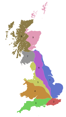
The numbering zones for A-roads in Great Britain
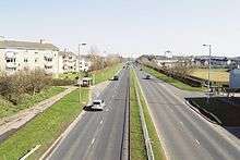
A726 in East Kilbride
List of A roads in the zone 7 in Great Britain starting north of the Solway Firth/Eden Estuary, west of the A7 and south of the A8 (roads beginning with 7).
Single and double digit roads
| Roads | South End | North End | Notes |
|---|---|---|---|
| Carlisle | Edinburgh | 92 miles (148 km) long. One of the longest trunk routes in Scotland. | |
| Ayr | Edinburgh | 74 miles (119 km) long.
The 2012 Collins Big Road Atlas shows the A70 as one of the five most dangerous roads in Scotland based on serious and fatal accidents between 2007 and 2009 in proportion to traffic.[1] | |
| Irvine | Edinburgh | Around 70 miles (112 km) long. | |
| Hamilton | Galashiels | 63 miles (101 km) long. | |
| Abington | Cumbernauld | 37 miles (60 km) long. | |
| Viewpark | Glasgow | ||
| Gretna | Stranraer | ||
| Dumfries | Kilmarnock | ||
| Portpatrick, Dumfries and Galloway | Glasgow | ||
| Greenock | Monkton | ||
| Ayr | Glasgow Prestwick Airport | 7.5 miles (12.1 km) long, making it the second shortest 2-digit A-road in the UK. |
Three and four digit numbers
| Roads | South End | North End | Notes |
|---|---|---|---|
| Sciennes, Edinburgh | New Town, Edinburgh | ||
| Dumfries | Edinburgh | ||
| St. John's Town of Dalry | Edinburgh | ||
| Peebles | Edinburgh City Bypass junction 6, Lothianburn | Runs as A701 between Bilston and Leadburn, Midlothian.
Route primarily within Scottish Borders Council district, southeastern Scotland. | |
| Miller's Moss | West Calder | ||
| Whitburn | Livingston | ||
| Lanark | Bo'ness | Replaced by A801 between Torphichen and Standhill. Formerly A8 between Standhill and Whitburn. | |
| Selkirk | Clovenfords | ||
| Moffat | Selkirk | The 2012 Collins Big Road Atlas shows the A708 as one of the five most dangerous roads in Scotland based on serious and fatal accidents between 2007 and 2009 in proportion to traffic.[1] | |
| Lockerbie | Dumfries | ||
| Dumfries | Dalbeattie | ||
| Dumfries | Argrennan | ||
| Crocketford | Newton Stewart | ||
| Castle Douglas | Ayr | ||
| Wigtown | Girvan | ||
| A715 | Unused | Ran from Whitecrook to Sandhead (now B7084). | |
| Whiteleys | Drummore | ||
| Stranraer | Stranraer | ||
| Stranraer | Kirkcolm | ||
| Turnberry | Fenwick | Passes over the Electric Brae. | |
| Musselburgh | South Gyle | Edinburgh City Bypass | |
| Kirkdean | Broomhouse | ||
| Wishaw | Newmains | ||
| Strathaven | Holytown | ||
| Rutherglen | Hamilton | ||
| Coatbridge | East Kilbride | ||
| Erskine | Strathaven | Re-routed via Glasgow Southern Orbital route from 2006 between East Kilbride and Newton Mearns. Former A726 between Peel Park and Deaconsbank now renumbered B766 and A727. | |
| Thorntonhall | Deaconsbank | Number formerly (pre-1980s) applied to what is now A8, A730, B766, B762, and B767 from Gorbals Cross to Clarkston. A727 number recreated in 2006 following opening of Glasgow Southern Orbital route, with new A727 taking over part of what was formerly numbered A726. | |
| Shawfield / Simshill | Parkhead / Gorbals | One part of the A728 forms the southern section of the Glasgow East End Regeneration Route, between Parkhead and Polmadie, roughly following the course of the abandoned Glasgow Outer Ring Road motorway proposals of the 1960s. The road was completed in 2012 as part of the Clyde Gateway project in preparation for the 2014 Commonwealth Games.
The other part is separate, running south from near Glasgow city centre, passing Hampden Park. | |
| Burnside | Gorbals Cross | ||
| Kilmarnock | Lugton | ||
| Barrhead | Irvine | Formerly (from its junction with Paisley Road West) the main road between Glasgow and Irvine. Runs from the A8 near Braehead, via Crookston, Barrhead and Shilford, into Irvine. | |
| Irvine | Glasgow | Formerly continued from Hollywood to Milliken Park (now B787), round the south east of Johnstone (now Beith Road; unclassified), to Elderslie (now B789) and onto Paisley to Glasgow (now A761 & A78). | |
| Ardeer Square | Kilwinning North Ayrshire | Formerly A78 through Ardeer Square. Plain A738 is because it is a huge town | |
| Cardonald | Bearsden | Incorporates the Clyde Tunnel in Glasgow | |
| A740 | Unused | Ran from Glasgow Airport to Johnstone (Now A737; old A737 became B787, Beith Road, B789, A761, and A78). Original route ran from Paisley to Old Kilpatrick (Now A726). | |
| Paisley | Renfrew | ||
| A742 | Unused | Ran from Greenock to Ardgowan (became A78; old A78 became A770). | |
| Lanark | Ravenstruther | ||
| A744 | Unused | Ran from Strathaven to Kirkfieldbank (now B7086). | |
| Dalbeattie | Castle Douglas | ||
| Bladnoch | Glasserton | ||
| Glasserton | Glenluce | ||
| A748 | Unused | Ran from A75 at Dunragit to A715 (which became B7084 after its cancellation). | |
| Glasgow | East Kilbride | ||
| A750 | Unused | Ran from Whithorn to Isle of Whithorn (now B7004). | |
| Aird | Innermessan | ||
| Thorniewood | Muirhead | ||
| Kirkcudbright | Girthon | ||
| Dumfries | Maxwelltown | ||
| A757 | Unused | Ran from Genoch Mains to Lochans (now B7077). | |
| Troon | Kilmarnock | ||
| Largs | Irvine | ||
| Greenock North Ayrshire | Ibrox | ||
| Tongland Bridge | St John's Town of Dalry | ||
| Cambuslang | Carmyle | ||
| A764 | Unused | Ran from Portpatrick to Portslogan (now B738). | |
| A765 | Unused | Ran from Ballantrae to Pinwherry (now B734). | |
| Nine Mile Burn | Penicuik | ||
| Bilston | Eskbank | ||
| A769 | Unused | Ran from Bogue to Balmaclellan (now B7075). | |
| Greenock | Glasgow | ||
| Greenock | Dunoon Ferry Terminal | ||
| Eskbank | Edinburgh | ||
| Mossend | Newhouse | ||
| Livingston | Bathgate | ||
| Dumfries | Douievale | ||
| Buccleuch St, Dumfries | Dockhead, Dumfries | ||
| A7066 | Boghall | Standhill | Formerly part of the A8 road (see also A89 and B7066). |
References
- 1 2 "Collins atlas rates five Scottish A roads 'high risk'". BBC News. 19 August 2011. Retrieved 11 November 2017.
This article is issued from
Wikipedia.
The text is licensed under Creative Commons - Attribution - Sharealike.
Additional terms may apply for the media files.