Westway (London)
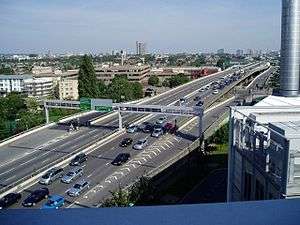
Westway is a 3.5-mile (5.6 km) long elevated dual carriageway section of the A40 trunk road in west London running from Paddington to North Kensington. The road was constructed between 1964 and 1970 to relieve congestion at Shepherd's Bush caused by traffic from Western Avenue struggling to enter central London on roads of insufficient capacity. Westway opened in July 1970 as the A40(M) motorway but lost motorway status in 2000 when responsibility for trunk roads in Greater London was transferred from the Highways Agency to the Greater London Authority.
Then Mayor of London, Boris Johnson, announced in March 2013 that over the coming years, parts of the Westway would be reconstructed to allow a separated cycleway to be built on it. The space required would be provided by reducing vehicle capacity.[1]
Route
At its eastern end, Westway starts to the west of the Marylebone Flyover (A501), which takes traffic over the junction of Edgware Road (A5) and Marylebone Road (A501). Between the elevated Westway and the flyover, a short (100 m) section of surface-level road allows westbound traffic from the flyover to turn-off on to the Harrow Road (A404) or eastbound traffic from the Harrow Road to access the flyover. Eastbound traffic from Westway cannot exit here to reach the Edgware Road and continues on to the flyover.
Heading west, Westway rises sharply as it passes Paddington Green (at this point having two lanes in each direction), then crosses the Grand Union Canal branch to Paddington Basin just south of Little Venice. As the road passes Westbourne Green on the north and Royal Oak Underground Station on the south, it gains a lane as a steeply climbing slip-road from Gloucester Terrace joins. In the eastbound direction, a lane is lost as a slip-road descends to cross the Network Rail tracks to Paddington station via the large plate-girder Westbourne Bridge, a road that previously carried traffic from Harrow Road to Bishops Bridge Road but was blocked at the north end and appropriated for the Westway scheme.
Continuing westward, Westway runs parallel with the Great Western Main Line railway for about 1⁄2 mile (0.80 km) before turning south-west at Westbourne Park and crossing the railway to run immediately adjacent to London Underground's Hammersmith & City line for 3⁄4 mile (1.2 km) as far as Ladbroke Grove station, after which it returns to a more east-west alignment for the 1⁄2 mile (0.80 km) to the elevated roundabout junction with the West Cross Route (A3220) and flyover that takes vehicles high above the roundabout and Wood Lane (A219) to return to ground level and connect to the end of Western Avenue.
With the extension westward of the London Congestion Charge Zone between 19 February 2007 and 4 January 2011, the part of the road between Westbourne Park and the Westway roundabout that passed through the zone was designated as a "free through route" that allowed vehicles to cross the zone without paying the charge.
Construction
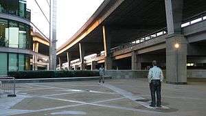
The route of the Westway was chosen to follow the easiest path from Western Avenue to Paddington by following the route of existing railway lines. Passing an eight lane elevated motorway through densely populated Victorian North Kensington, though, involved the clearance of a large number of buildings adjacent to the railway, particularly in the area west of Westbourne Park, where many roads were unceremoniously truncated or demolished to make way for the concrete structures. The main contractor was John Laing & Sons.[2]
At its opening the road was the largest continuous concrete structure in Britain, and was constructed with many advanced features, such as heating grids on slopes to control the formation of ice. It was planned and constructed in an era before environmental impacts were routinely considered, and it caused much controversy at the time for the effects it and the vehicles it carried had upon the local community and the environment. After completion a vast corridor of wasteland remained below the motorway. The North Kensington Amenity Trust (now Westway Development Trust), was founded in 1971 to reclaim and develop this land for local community use, and since 2000 local charity Urban Eye has initiated a programme of cleaning, painting, and lighting to brighten up and improve the safety of the areas under the flyover structure.[3]
Context
- See London Ringways for a detailed history
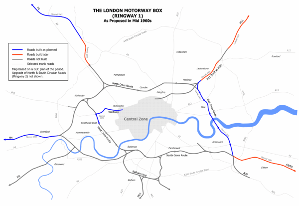
The Westway was built to form a link from Paddington to Ringway 1, the innermost circuit of the London Ringways network, part of a complex and comprehensive plan for a network of high speed roads circling and radiating out from central London designed to manage and control the flow of traffic within the capital. This plan had developed from early schemes prior to the Second World War through Patrick Abercrombie's County of London Plan, 1943 and Greater London Plan, 1944 to a 1960s Greater London Council (GLC) scheme that would have involved the construction of many miles of motorway standard roads across the city and demolition on a massive scale. Due to the huge construction costs and widespread public opposition, most of the scheme was cancelled in 1973 and the Westway, the West Cross Route and East Cross Route in east London were the only significant parts to be built.
The construction of the elevated roundabout junction with the West Cross Route was built with the capability to be extended once the planned northern continuation of the West Cross Route was constructed to Harlesden. Two stubs on the roundabout's north side were built for the connection of slip roads and the alignment of the slip roads between the West Cross Route and the roundabout avoided the planned line of the road to the north.
Popular culture
The 1997 murder mystery A Certain Justice by P. D. James was set in an area being demolished for the Westway. "But their world was crashing down with their houses, rising in great choking clouds of ochre dust".
The 1974 novel Concrete Island by J. G. Ballard was set in a junction between the Westway and M4 Motorway.
Westway was a BBC radio series that ran from 1997 until 2005.
The Westway has featured in songs by many British Rock bands:
- "Westway" is the title of a tune by the 1980s rock band Sky. On the album notes bass player Herbie Flowers, who co-wrote the tune with Francis Monkman, says of "Westway": "When we recorded this album, I was living out in West London, and the studio was in Central London. Every night, I would drive home along the Westway elevated road and listen on my car tape player to what we'd done that day. This track is such a great groove for driving and it got its name because if I put it on at the Marylebone Road end of the Westway and stuck right on the speed limit, it would finish just as I came off the other end."
- The Clash gave the Westway a sarcastic mention in "London's Burning": "I'm up and down the Westway, in and out the lights. What a great traffic system, it's so bright. I can't think of a better way to spend the night, than speeding around underneath the yellow lights."
- The cover for The Jam's This Is The Modern World was taken under the Westway.[4]
- Scritti Politti's song '28/8/78' features a sample from the Radio 4 programme The World Tonight of a British journalist reporting on a disturbance at the Notting Hill Carnival which was held on 28th August 1978. "The trouble flared in exactly the same place as last year; where the Portobello Road passes under the Westway motorway".
- In the Blur song "For Tomorrow" part of the lyrics state that a couple have lost their way on the road. The full line is: "London's so nice back in your seamless rhymes, But we're lost on the Westway". The Westway is also mentioned in Blur's songs "Fool's Day" and "Under the Westway".
- Dirty Pretty Things refer to the Westway in the song "Truth Begins", in the lines "The Westway walls so tall and bleak / Reflect the words we dare not speak".
- The Westway is referenced in Pete Doherty's "Broken Love Song", in the line "By the Westway, Inside The Scrubs", as he claimed to have once lived beside the Westway in a caravan.[5]
- In the Alex Rider series, a crash is staged on the Westway.
- In the film Nuns on the Run, the Westway can be seen in the background in one of the scenes.[6]
- The Westway is also featured on the front cover of A Weekend in the City by Bloc Party. The picture, part of A Modern Project was taken by German photographer Rut Blees Luxemburg.
- Justin Clack of Frost Meadowcroft writes about the Westway in Umbrella Magazine issue 4 in an article "Something In The Air" . It refers to the fact that no compensation was granted to any resident's properties who overlooked the motorway if their houses were not actually demolished by its construction; and how the famous squat and "independent state" Frestonia was set up in its shadow.[7]
- The Don Letts documentary about The Clash, Westway to the World, refers to the Westway.
References
- ↑ ""Crossrail for the bike" in Mayor's £913m cycling plan" (Press release). Greater London Authority. 7 March 2013. Retrieved 2013-03-17.
- ↑ Ritchie, p. 141
- ↑ "Urban Eye". Retrieved 13 September 2015.
- ↑ Thorogood, Tom; Rollings, Grant (28 March 2012). "How the view has changed on classic album covers". The Sun. London. Retrieved 18 June 2012.
- ↑ "Road to ruin: Doherty living under the Westway". drownedinsound.com. Retrieved 3 April 2018.
- ↑ http://www.reelstreets.com/index.php?option=com_films_online&task=view&id=703&film_ref=nuns_on_the_run&Itemid=3&limitstart=50
- ↑ "Something In The Air, The Story of The Westway and Frestonia". frostmeadowcroft.com. Retrieved 3 April 2018.
Sources
- Ritchie, Berry (1997). The Good Builder: The John Laing Story. James & James.
External links
- Westway.org – Notes on the history of Westway
- Motorway Archive – A40(M) Westway and M41 West Cross Route
- Pathetic Motorways – A40(M) Photographs
- Something In The Air, The Story of The Westway and Frestonia
Coordinates: 51°30′56″N 0°13′15″W / 51.51556°N 0.22083°W
| Great Britain | .svg.png) | |||||
|---|---|---|---|---|---|---|
| Northern Ireland | ||||||
| Former | ||||||
| Unbuilt | ||||||
| Proposed | ||||||
| Junctions | ||||||
| Related articles | ||||||
| ||||||