400 kV Thames Crossing

The 400 kV Thames Crossing is an overhead power line crossing of the River Thames, between Botany Marshes in Swanscombe, Kent, and West Thurrock, Essex, England. Its towers are the tallest electricity pylons in the UK.
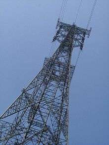

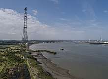

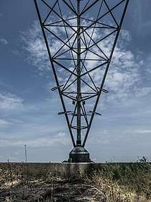
The present crossing was built in 1965, and comprises two 190-metre (623 feet) tall lattice towers each side of the Thames. Some suggest that the choice of this height was deliberate, being just taller than the BT Tower in London.[1] The span is 1372 metres (4501 feet), the minimum height of the conductors over the river is 76 metres (249 feet). Each tower has three crossarms and carries two circuits of 400 kV three-phase AC.
132 kV Thames Crossing
There was at one time an earlier 132 kV crossing nearby, with towers 148.4 metres tall. Linking Dagenham and Crossness, it was built between 1927 and 1932 and was part of the Belvedere-Crowlands 132/33/25 kV double circuit.[2] With the cessation of generation at Belvedere Power Station, this line was dismantled in 1987.
2006 death
In March 2006, Paul Smith-Crallan attempted to BASE jump from a platform on the Swanscombe Tower. The parachute he was using is believed to have failed to open, causing him to plunge to his death. This tower is a popular base jumping location because of two platforms that provide good launch points.[3]
See also
References
- ↑ News, Greater London Industrial Archaeology Society, February 2003, archived from the original on 2003-03-08
- ↑ Barry, Howard. "Power Over the Thames". Wonders of World Engineering. Amalgamated Press (46): 1321–1324. Retrieved 24 December 2014.
- ↑ Kirby, Terry (2006-03-15). "Base-jumper killed in leap from 600ft electricity pylon". The Independent.
External links
- News, Greater London Industrial Archaeology Society, December 2002, archived from the original on 2003-01-17
- News, Greater London Industrial Archaeology Society, February 2003, archived from the original on 2003-03-08
- Diagram of the towers, Skyscraperpage
Coordinates: 51°27′44.06″N 0°18′21.19″E / 51.4622389°N 0.3058861°E